Download
1 / 34
390 likes | 672 Views
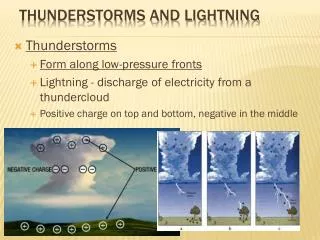
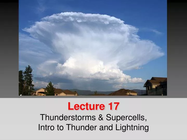
Lecture 17 Thunderstorms & Supercells , Intro to Thunder and Lightning. Thunderstorms - Intro. A storm that generates lightning and thunder . Are characterized by strong “up” and “ down” motions Frequently produces gusty winds, heavy rain and hail. Thunderstorms - Intro.

E N D
Lecture 17Thunderstorms & Supercells, Intro to Thunder and Lightning
Thunderstorms - Intro • A storm that generates lightning and thunder. • Are characterized by strong “up” and “down” motions • Frequently produces gusty winds, heavy rain and hail.
Thunderstorms - Intro • They can form on their own • They can form in conjunction with mid-latitude cyclone • Edge of a Cold-Front • The can form in conjunction with hurricanes
Thunderstorms - Intro • Florida has the most thunderstorms • 80-100 on average per year! • Commonly occur in the foothills of the Rockies • Associated with Tornado Alley in the middle of the country • Associated with drylines and air with different humidities
Thunderstorms - Intro • Form when warm, humid air rises in an unstable environment • There are two categories: • Air Mass Thunderstorms – formed by unequal heating of the Earth’s surface within a maritime tropical (mT) air mass. • Severe Thunderstorms – formed by unequal heating & lifting of warmair along a front or mountain.
Airmass Thunderstorms • Happens inside an air mass (usually mT) • Usually in spring and summer • Usually in mid-afternoon • Not associated with a front • Due to local differences in temperature
Airmass Thunderstorms • Like mid-latitude cyclones T-Storms have a “Life Cycle” • Stages of Development • Stage 1: Cumulus Stage • Stage 2: Mature Stage • Stage 3: Dissipating Stage
Airmass Thunderstorms Stage 1 Stage 2 Stage 3
Stage 1: Cumulus stage • Rising air only • Makes a cloud • Cloud gets bigger and bigger • Moisture is being added to higher and higher altitudes • Needs a continuous supply of moisture to survive
Airmass Thunderstorms Stage 1 Stage 2 Stage 3
Stage 2: Mature Stage • Precipitation forms • Mainly by the Bergeron Process • Rain begins to fall • Associated with the downdraft (air going down) • Most active stage • Gusty winds, lightning, heavy rain, hail • Updrafts and downdrafts exist side by side
Stage 2: Mature Stage • Downdraftsform for two reasons • Entrainment – mixing of dry air with cloud air at the edge of the cloud • Causes the cloud drops to evaporate • Energy from evaporation comes from the temperature of the air parcel • By evaporating drops, you use up the energy and end up cooling the air parcel • Temperature drops, parcel cools • Cooler air sinks to the surface • Drag – Air is dragged downwards as precipitation falls.
Airmass Thunderstorms Stage 1 Stage 2 Stage 3
Stage 3: Dissipating Stage • Cooling effect of falling precipitation and influx of colder air up top mark it’s END! • Downdraftcuts off updraft • Cloud stops growing • You’re left with weakly descending air parcels • The cloud basically KILLS itself
Airmass Thunderstorms - Summary Stage 1 Stage 2 Stage 3 The most intense phase, with heavy rain and possibly small hail, in which downdrafts are found side by side with updrafts Stage in which updrafts dominate throughout the cloud, and growth from a cumulus to a cumulonimbus occurs. Dominated by downdrafts and entrainment, causing evaporation of the structure.
Severe Thunderstorms • Heavy downpours, flooding, gusty straight-line winds, large hail, lightning and tornadoes! • To be classified as Severe: • Must have winds in excess of 93 km/h or 58 mph • or hail 0.75 inches • or a confirmed tornado
Multi-Cell Thunderstorms • Thunderstorms that contain a number of cells • Each cell is in a different stage of development • Form in regions of moderate-to-strong vertical wind shear.
Severe Thunderstorms Overshooting Top • Persist for many hours • Vertical wind sheer causes precipitation to fall in downdraft, allowing the updraft to retain strength. • Sometimes the updraft is so strong you get overshooting tops and anvils! Anvil
Severe Thunderstorms • Cold air of the downdrafts spread out making: • “mini cold front” • Called a GUST FRONT • Called an Outflow Boundary • Can form a Roll Cloud
Supercell Thunderstorms • Causes dangerous weather • 2000-3000 a year • Large, very powerful, up to 20 km in height • Last many hours • 20-50 km in diameter
Supercell Thunderstorms • Vertical wind profile may cause the updraft to ROTATE! • MESOCYCLONE– usually spawns Tornadoes! • Need a lot of Latent Heat • Requires moist troposphere • An inversion a couple of km above the surface (caps moisture) • Unstable air can break through the inversion by “eroding” it via mixing.
Supercell Diagram Hail
Squall Lines • Develop in the warm sector of a Mid-Latitude Cyclone • 100-300 km in ADVANCE of the cold front. • Linear in shape • Can last for 10 hours or more
Squall Lines • Sometimes preceded by mammatus clouds • Form when the divergence and resulting lift created by the jet stream is aligned with strong persistent low level flow of humid air from the south. • Also can form on drylines
Mesoscale Convective Complexes • Consist of many individual T-storms organized into a large oval or circular cluster. • MCCs are BIG • At least 100,000 sq km in area (39,000 sq miles) • MCCs are SLOW • Can persist for up to 12 hours
Mesoscale Convective Complexes • Associated with tornadoes • Typically form in the Great Plains from a group of afternoon air-mass T-Storms. • To transform from air-mass T-Storm to MCC you need lots of low level warm and moist air.
Microbursts • Localized downdraft • About 2.5 miles (4 km) across • Downdraft is accelerated by evaporative cooling • Typically last 2-5 minutes
Microbursts • Outflow at the surface can move in excess of 160 km/hr (100 mph). • Microbursts can cause quite a bit of destruction. • Tress, homes, aircraft…
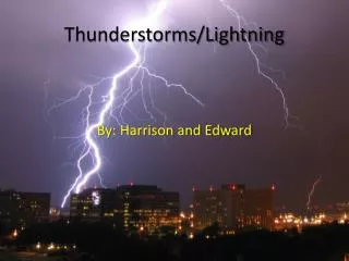
Lightning and Thunder • A storm is classified as a thunderstorm only after thunder is heard!! • Because thunder is produced by lightning, lightning must also be present! • We’ll talk about both Lightning and Thunder!
Lightning • Lightning is a discharge of electrical energy. • Essentially a giant “spark” between regions of positive (+) and negative (-) charge.
Lightning • May occur: • Between cells in the same storm • inter-cloud lightning • Within a cloud • intra-cloud lightning • Cloud to air • Cloud to ground (CG)
Lightning Formation • Lightning forms when a charge separation occurs in a cloud • The earth trying to equalize the electrical difference • Negative charges want to flow to the ground.
Charge Separation • We don’t exactly know why it happens • One theory: • Hail stones tend to have a warmer surface than ice crystals • When warm hail collides with colder ice, electrons transfer from ice to hail • Hail (-) is bigger and heavier and settles toward the bottom of the cloud • Smaller (+) ice crystals are lofted to the top.