Download
1 / 25
260 likes | 609 Views
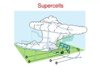
Miniature-Supercells. 2006 NWS Southern Region SOO Conference 11July 2006 . Jeffrey M. Medlin National Weather Service Mobile, Alabama. Definition. What is a ‘ miniature supercell ?’

E N D
Miniature-Supercells 2006 NWS Southern Region SOO Conference 11July 2006 • Jeffrey M. Medlin • National Weather Service • Mobile, Alabama
Definition • What is a ‘miniature supercell?’ • ‘Supercell’ – Is synonymous with the term ‘mesocyclone’ and represents a thunderstorm whose updraft rotation is: • Relatively deep compared to overall updraft depth • Temporally persistent • Possesses a minimum strength (or rate) of rotation • In the early 1990s, an attempt was made to classify storms according to their internal dynamic organization and –NOT- cellular composition First, let’s examine the term…
Definition • What is a ‘miniature supercell?’ • ‘Supercell’ - Two historical references: • Long before thunderstorm observations by Doppler radar, Brooks (1949) found that the tornado cyclone was often closely associated with the rotating updraft of a supercell thunderstorm. • The structure was labeled a ‘mesocyclone’ and was essentially found to be the parent circulation of the tornado (Fujita, 1985).
Definition Kansas • Now…what makes a mesocyclone ‘miniature?’ • Is it strictly visual? Photo courtesy: Jonathan Davies http://members.cox.net/jondavies1/tornado_fcsting/tor_minisprcll.jpg
Definition Coastal Alabama • … versus formation in Coastal Alabama! 13 Oct 2001-Mesocyclone prior to producing F3 intensity tornado near Foley, AL Photo courtesy: NWS Mobile, AL (SKYWARN Spotter name unknown)
Definition This image compares the KMOB 0.5 deg storm relative velocity image(SRM) valid 1819 UTC, with a spotter photograph of the F3 tornado taken around the same time. Photo courtesy:NWS Mobile, AL (SKYWARN Spotter name unknown)
Definition • What makes a mesocyclone ‘miniature?’ …or…is it defined by certain radar attributes like diameter of rotation? Photo courtesy: NWS Mobile, AL
Definition • What makes a mesocyclone ‘miniature?’ Storm Top and storm top? *Reduced CAPE = lower EL Photo courtesy: NSSL SWAT Homepage
Definition • What makes a mesocyclone ‘miniature?’ Is it the depth of rotation?
Definition Nebraska • What makes a mesocyclone ‘miniature?’ They even seem to form within a variety of Synoptic settings… ‘500 mb Cold-Core’ mini-supercell over Nebraska – 18 April 2003
Definition Hurricane Frances - Sep 2004 - • What makes a mesocyclone ‘miniature?’ …within different geographic locales and at different times of the year! Photo courtesy: NWS Raleigh, NC
Definition …and even occur throughout the world!... Adapted from Suzuki et al., 2000 (MWR, Vol. 128, No. 6, pp.1868-1882) Typhoon 9019 and mini-supercells on the Kanto Plain, Japan
Definition … Formal literature searches yield very little… Your search criteria: Journal(s): All Date Range: All Words from Title (ALL) : mini supercells Sort by: Relevance Search Results: Articles Found: 1 Your search criteria: Journal(s): All Date Range: All Words from Title (ALL) : miniature supercells Sort by: Relevance Search Results: Articles Found: 0 Your search criteria: Journal(s): All Date Range: All Words from Title (ALL) : shallow mesocyclones Sort by: Relevance Search Results:Articles Found: 0 Your search criteria: Journal(s): All Date Range: All Words from Title (ALL) : shallow supercell Sort by: Relevance Search Results: Articles Found: 1
Then, I ask, “What is ultimately important?” • After numerous examples of mini-supercells, and at the expense of not further ‘compartmentalizing’ storms based on their sampled appearance, we need to ask ourselves, “What is ultimately most important to those tasked with radar warning responsibility?” • Let’s more closely examine: • Associated pre-storm environmental Conditions • Associated radar reflectivity and velocity characteristics • Radar Sampling Limitations
Pre-storm Environmental Conditions1 • Modest Thermodynamic Instability resulting in: • CAPE range -> 300-1500 J kg-1 • CAPE average -> 600-1000 J kg-1 • Foster et. al., (1995) and Wicker andCantrell, (1996) • Moderate to strong vertical wind shear resulting in: • Sr Helicity range -> 200-700 m2 s-2 • Sr Helicity average -> 200-400 m2 s-2 • Foster et al., (1995), Guerrero and Read (1993) and Korotky (1988) • Thus, forecasters have the ability to anticipate days when ‘mini-supercells’ may occur (i.e., modest CAPE and moderate-high Sr Helicity values).
Pre-storm Environmental Conditions2 • It has been shown, however, that one cannot assess the total value of CAPE alone, but rather, what is considered most important is the vertical distribution of thermodynamic instability with height: • Eugene W. McCaul Jr. and Morris L. Weisman. 2001: The Sensitivity of Simulated Supercell Structure and Intensity to Variations in the Shapes of Environmental Buoyancy and Shear Profiles.Monthly Weather Review: Vol. 129, No. 4, pp. 664–687. • David O. Blanchard. 1998:Assessing the Vertical Distribution of Convective Available Potential Energy.Weather and Forecasting: Vol. 13, No. 3, pp. 870–877. • Eugene W. McCaul Jr. and Morris L. Weisman. 1996:Simulations of Shallow Supercell Storms in Landfalling Hurricane Environments.Monthly Weather Review: Vol. 124, No. 3, pp. 408–429. • Eugene W. McCaul Jr.. 1991: Buoyancy and Shear Characteristics of Hurricane-Tornado Environments.Monthly Weather Review: Vol. 119, No. 8, pp. 1954–1978.Blanchard (1998), WAF Note
Pre-storm Environmental Conditions3 • Normalizing the CAPE by varying integration depths allows for a more direct assessment of updraft vertical acceleration as related to updraft stretching of horizontal vorticity after having been tilted into the vertical (and the eventual development of dynamic pressure perturbations which promotes storm longevity). • McCaul and Weisman (1996) found in their zero wind simulations using vertical profiles with the same CAPE (800 J kg-1), that by varying the height at which the maximum buoyancy occurs, updraft magnitude nearly doubled (~35 m/s, at 2.75 km versus ~19 m/s at 5.82 km). • Wicker and Cantrell (1996) also showed that the coupling of low-level vertical shear and low-level CAPE (i.e, lowest 1-2 km) appeared to be more important to the development of updraft rotation than did large values of CAPE throughout a deeper convective layer (sfc->LFC).
Radar Reflectivity and Velocity Characteristics • Radar observation has shown mini-supercells are low-topped (6-8 km) convective storms with small rotational diameters 2.7 kft 3.7 kft 1.2 kft 5.5 kft 9.6 kft 7 kft
Radar Reflectivity and Velocity Characteristics …and tend to possess lower maximum radar reflectivity with both reduced horizontal and vertical extent 2.7 kft 3.7 kft 1.2 kft 5.5 kft 9.6 kft 7 kft
Radar Reflectivity and Velocity Characteristics 2.7 kft 4.1 kft 1.2 kft Divergent component 5.5 kft 9.6 kft 7 kft Photos courtesy: NSSL SWAT Homepage
Radar Reflectivity and Velocity Characteristics …and we have already seen that WERs, BWERs and Hooks can occur, (although reduced in horizontal and vertical extent)
Radar Reflectivity and Velocity Characteristics • Compared to traditional supercells, Burgess1 et al. (1995) found that ‘mini-supercells’ possessed weaker (44 vs. 28 kt) rotational velocities throughout their mature stages, but both had the same relative increase in rotation rate between their organizing and mature stages. • Wicker and Cantrell (1996),Grant and Prentice (1996) and Darbe and Medlin (2005) more closely examined horizontal shear (to include observed smaller diameters). When smaller diameters were considered, less of a difference existed between mini-supercells rotation rates and their classic counterparts (practical experience). 1- Burgess et al. (1995) studied these within 55 n mi of a single-Doppler radar. He examined the organizing, mature and dissipating stages for each group.
Radar Reflectivity and Velocity Characteristics Note the near sudden doubling in Max Vr Shear from T0-2 to T0 Grant and Prentice (1996) – 16 tornado-producing mesocyclones assoc/w mini-supercells Darbe and Medlin (2005) – six tornado- producing mesocyclones assoc/w mini-supercells – 13 Oct 2001
Radar Sampling Limitations New VCPs do not entirely solve the problem! Radar Horizon VCP-12 Aspect Ratio Un-balanced Mesocyclone Signatures
Concluding Remarks • Provided a brief ‘documentary’ on mini-supercells (as much as 15 minutes would allow) to address: • Naming convention - Avoid ‘further compartmentalization’ • How did we arrive to where we are now? • Citing of significant research and formal references • Very briefly discussed most significant operational impacts: • Definition of the mesocyclone. • Pre-storm environmental characteristics. • Reduced vertical and horizontal dimensions and impact of radar sampling. • Questions and/or Comments? • Thank You!