Download

1 / 23
240 likes | 392 Views
Ocean Currents. Nelson Science 10 Section 13.9 (525) Weather Dynamics Unit Science 10 Mrs. S. Pipke-Painchaud. Weather and Oceans. Oceans are very important in creating global weather patterns. Occupy a large portion of the earth’s surface Most land masses are found at 45* north

E N D
Ocean Currents Nelson Science 10 Section 13.9 (525) Weather Dynamics Unit Science 10 Mrs. S. Pipke-Painchaud
Weather and Oceans • Oceans are very important in creating global weather patterns. • Occupy a large portion of the earth’s surface • Most land masses are found at 45* north • What does this mean? • There is a lot of water at the equator to absorb the sun’s rays. • What is the purpose of ocean currents? • Distribute the energy around the world • (Nelson Science 10 525)
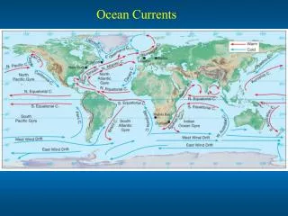
Red = warm currents / Black = cold currents / Orange = water of 20°C or more http://www.starfish.ch/reef/ocean.html
Ocean Currents (top) Wind Patterns (Bottom) ~ Do you notice any similarities or differences?
Iceland and Norway are located at what latitude? What climate would you expect them to have based on their similarity to the same Canadian latitude?
Norway and Iceland have harbors that remain ice free all winter. Why?? http://www.bigelow.org/shipmates/hc_currents_lg.gif
Because of the Gulf Stream, which transports warm water from the Gulf of Mexico • Ocean currents transport energy stored in the water from one part of the world to other parts (warm to cold) • Cold currents flow toward the equator and warm as they travel through the region. • (Nelson Science 10 525)
Causes of Ocean Currents • Convection currents • Wind • Earth’s rotation • Shapes of the continents • Heat capacity of water • Amount of salt in water
Warm water travels North or South from the equator. • Cold water is opposite • Warm water is less dense; Cold water is denser • The sun’s energy is most intense at the equator starts convection currents • Water warmed by the sun’s rays at the surface moves north or south, the cold water from the bottom moves up to the surface. • (Nelson Science 10 526)
Edges of the continents: • Currents follow this like a river would • Earth rotates eastward • Currents on the West side of the oceans narrow and faster (6.5 km/h) • Currents on the East side wider and slower (1.1 km/h) • What is the only current that travels around the world without running into any continents? • Antarctic Circumpolar • (Nelson Science 10 526)
Water ~ Heat Sink • Remember that water takes a long time to heat up and a long time to cool off. • Salt • As warm water evaporates it leaves behind saltier currents. • Saltier water is more dense sinks deep water currents • (Nelson Science 10 526)
Effects of Ocean Currents • Remember the warmer the air the more moisture it can hold. • If a cold ocean current runs by a coastal areas, then the air is cooler and drier (may cause a desert). • Peru current is cold = cold, dry air = Atacama Desert
Atacama Desert http://digilander.libero.it/luigipizzi/Atacama.jpg
“Bounded on the west by the Pacific and on the east by the Andes, the Atacama Desert only knows rainfall between two and four times a century. . . There are some parts of the desert where rainfall has never been recorded. The only moisture available comes from a dense fog known as camanchaca, formed when cold air associated with ocean currents originating in the Antarctic hits warmer air. This fog is literally harvested by plants and animals alike, including Atacama's human inhabitants who use 'fog nets' to capture it for drinking water” (Universe Today). http://www.universetoday.com/am/publish/printer_atacama_desert_space.html
Warm currents cause water to evaporate clouds large amounts of precipitation • Ex. Brazil Rainforests http://www.bugbog.com/gallery/brazil_pictures/brazil_pictures_1.html
Red shows logging http://www.aaas.org/news/releases/2005/1021scipak.shtml http://en.wikinews.org/wiki/Category:South_America
Ocean Currents and Climate • Coastal regions are warmer in the winter and cooler in the summer. • i.e. Ottawa vs Newfoundland • Ottawa has a 30 degree difference between winter and summer • Newfoundland (further north) has only an 18 degree difference.
High Heat Capacity of Water • Our warmest months are June, July and August even though we have more solar energy in May, June and July. Why? • Water takes a while to warm up • Same effect in the winter • Less daylight in November, December and January, but we are colder in December, January and February.
Global Weather Model • Please refer to page 536 • Read through the info presented • Discuss the following text questions together. • Questions on page 527 • 1 (b,c,d), 4, 5, 6
Resource Sites: • University of Miami • http://oceancurrents.rsmas.miami.edu/ • Ocean Planet – Smithsonian • http://seawifs.gsfc.nasa.gov/OCEAN_PLANET/HTML/oceanography_currents_1.html
Sources • Nelson Science 10 Textbook • Section 13.9 • Universe Today – Atacama Desert • http://www.universetoday.com/am/publish/printer_atacama_desert_space.html