Download

1 / 26
280 likes | 397 Views
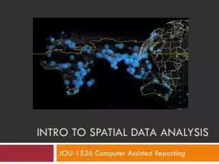
Intro to Spatial Analysis (mostly 2D) . Some GIS Queries. How big is the lake? What is the longest trail? How many fire hydrants on campus? Which dorms are within 100 m of an academic building? Where is the best place for a new dorm?. Types of queries.

E N D
Intro to Spatial Analysis (mostly 2D) CS 128/ES 228 - Lecture 12a
Some GIS Queries • How big is the lake? • What is the longest trail? • How many fire hydrants on campus? • Which dorms are within 100 m of an academic building? • Where is the best place for a new dorm? CS 128/ES 228 - Lecture 12a
Types of queries • Aspatial – make no reference to spatial data • Which dorm has the highest occupancy rate? (we can already do) • Spatial – make reference to spatial (and possibly attribute) data • Which fire hydrant is closest to the chemistry labs? (we can sort of do) CS 128/ES 228 - Lecture 12a
Time for some geometry! CS 128/ES 228 - Lecture 12a
“Simple” spatial queries • How long is this line? • “Tricky” if line is a bunch of line segments • “Tricky” if distance isn’t Pythagorean • How much area does this polygon cover? (Can we do this?) • Is this point in this polygon? (Can’t do this!) CS 128/ES 228 - Lecture 12a
Conventional Distance • The Pythagorean Theorem helps us compute “conventional” distances in the plane • Of course ArcMap does it automatically CS 128/ES 228 - Lecture 12a
“Alternative” distance B • “Manhattan” distance • How many blocks (via a taxi cab) from A to B? • ArcMap can do this in a query/report A What about one-way streets? CS 128/ES 228 - Lecture 12a
Not your mother’s “Distance” More complex distances require more complex analysis CS 128/ES 228 - Lecture 12a
A B C Area (by vector) • Area of a rectilinearly aligned trapezoid is easy. C*(A+B)/2 CS 128/ES 228 - Lecture 12a
Area (by vector) • For a polygon, add up the (signed) trapezoidal areas CS 128/ES 228 - Lecture 12a
or Area (by Raster) • Simply count the rasters inside the polygon How big is this? CS 128/ES 228 - Lecture 12a
Area (by ArcMap) CS 128/ES 228 - Lecture 12a
2 Crossings => OUTSIDE 3 Crossings => INSIDE Points in Polygon • Send out a “ray” and count the crossings. • ODD implies inside • EVEN implies outside CS 128/ES 228 - Lecture 12a
Overlaying vector layers Spatial information (from layers) can be used to create new spatial information (i.e. new layers) CS 128/ES 228 - Lecture 12a
Overlaying Layers (Intersection) • Keep only those things that belong to both layers • Example: Overlay my property with a hydrology layer • Learn how much of my “land” is under water. • What to do about the property boundary and the lake? CS 128/ES 228 - Lecture 12a
Overlaying Layers (Intersection) • Keep any things that belong to either layer • Example: Overlay state highways layer and local roads layer to create pavement layer Note: New Layer not actually created in this figure CS 128/ES 228 - Lecture 12a
Overlaying Layers (Clipping) • Keep only those things from a given layer that lie within a specified boundary (often rectangular) • Example: Consider only those roads that lie within Cattaraugus County • Problem: What if a road crosses the boundary? CS 128/ES 228 - Lecture 12a
DIGRESSION: What are rasters? • Vector layers with a single attribute datum? CS 128/ES 228 - Lecture 12a
Overlaying Rasters • Simple Mathematics will often suffice • But there is less information CS 128/ES 228 - Lecture 12a
Effective Overlaying via Reclassification • Data is not always in a good format • If raster pixels have different coverages, overlaying may be effectively impossible • Codings are generally categorical, not mathematical • Adding codings usually does not make sense • Solution: RECLASSIFY CS 128/ES 228 - Lecture 12a
A Sample Reclassification CS 128/ES 228 - Lecture 12a
Buffering – another tool • Buffering (building a neighborhood around a feature) is a common aid in GIS analysis CS 128/ES 228 - Lecture 12a
Using Buffers to Select • Select the features • Save the features as a layer • (Export) CS 128/ES 228 - Lecture 12a
Putting it all together • Siting a nuclear waste dump • Build Layer A by selecting good geology • Build Layer B by reclassifying population for high density • Build Layer C by clipping B from A • Build Layer D by buffering roads • Build Layer E by intersecting C and D • … See also: Box 6.5, pp. 187-88 CS 128/ES 228 - Lecture 12a
Where does it fit in? • GIS holds data • Spatial analysis causes us to view the data as information • Combining queries turns that information into knowledge (It’s all a spectrum) CS 128/ES 228 - Lecture 12a
Conclusions • A GIS without spatial analysis is like a car without a gas pedal. There are some things you can still do with it, but it’s hardly worth maintaining the vehicle. CS 128/ES 228 - Lecture 12a