Download
1 / 16
160 likes | 165 Views
Global Space-based Inter-Calibration System (GSICS) Progress Report. Mitch Goldberg, NOAA/NESDIS GSICS Executive Panel chair. What is GSICS?. Global Space-based Inter-Calibration System (GSICS)

E N D
Global Space-based Inter-Calibration System (GSICS)Progress Report Mitch Goldberg, NOAA/NESDIS GSICS Executive Panel chair
What is GSICS? • Global Space-based Inter-Calibration System (GSICS) • Goal - Enhance calibration and validation of satellite observations and to intercalibrate critical components global observing system • Part of WMO Space Programme • GSICS Implementation Plan and Program formally endorsed at CGMS 34 (11/06)
GSICS Mission To provide sustained calibration and validation of satellite observations To intercalibrate critical components of the global observing system to climate quality benchmark observations and/or reference sites To provide correction coefficients and algorithms to the user community for current and historical data 3
Inter-Calibration is Critical for Climate Change Detection Before intercalibraion After intercalibration Trend of global oceanic total precipitable water decreases from 0.54 mm/decade to 0.34 mm/decade after intercalibrations! Calibration uncertainties translate to uncertainties in climate change detection 4 4
Current focus of GSICS Interagency collaboration on algorithms (GRWG) and data exchange and formats (GDWG) Product acceptance and documentation requirements, metadata standards, data formats, website standards Routine intercalibration (monitor and correct) of all operational GEO Infrared imagers using IASI and AIRS MODIS and Deep Convective Clouds for visible channels 5 5
Current focus of GSICS Intercalibration of LEO instruments HIRS, SSMI, AMSU, MHS, AVHRR, AIRS, IASI, FY3, GOME-2, OMI, SBUV Traceability Campaigns Key collocation datasets Requirements for pre-launch calibration Root causes and corrections 6 6
First GSICS Guideline document Best Practice Guidelines for Pre-Launch Characterization and Calibration of Instruments for Passive Optical Remote Sensing Report to GSICS Executive Panel R.U. Datla, J.P. Rice, K. Lykke and B.C. Johnson (NIST) J.J. Butler and X. Xiong (NASA) September 2009
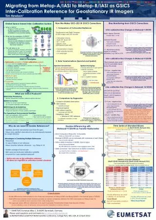
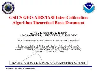
First international coordinated GSICS project is the intercalibration of geostationary infrared channels with IASI and AIRS IASI AIRS Ch2 Ch4 Ch3 Ch6 Web Accessible 8 8
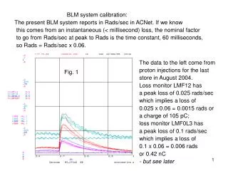
GSICS Correction Algorithm for Geostationary Infrared Imagers GSICS will provide correction coefficients for all GEOs from 2003 (beginning of AIRS record) to present The first major deliverable to the user community is the GSICS correction algorithm for geostationary satellites. The user applies the correction to the original data using GSICS provided software and coefficients. The correction adjusts the GOES data to be consistent with IASI and AIRS. The figures to the left show the difference between observed and calculated brightness temperatures (from NCEP analysis) before and after correction The bias is reduced from 3 K to nearly zero. Before 3K Bias After: ~ 0K Bias 9
Status of GEO-LEO Inter-Calibration AIRS IASI current Jan/07 Jan/08 Jan/09 Jan/10 GOES-11 GOES-12 GOES-13 Jun/07 Aug/08 Meteosat-9 Meteosat-7 MTSAT-1R FY-2C FY-2D Near-real time monitoring and correction for six operational GEO with baseline algorithm GSICS Executive Panel Meeting
Impacts of GSICS Correction for SEVIRI on GFS Forecast MSG SEVIRI CSR withand without GSICS bias correction Anomaly Correlation for 500 mb height over tropics (left) and NH (right)
IMPACT on Cloud Coverage ClassificationMSG March 2009 Before GSICS correction After GSICS correction
Recent ApplicationsCharacterization of Midnight Blackbody Calibration Anomaly GSICS Executive Panel Meeting