Download
1 / 46
460 likes | 657 Views
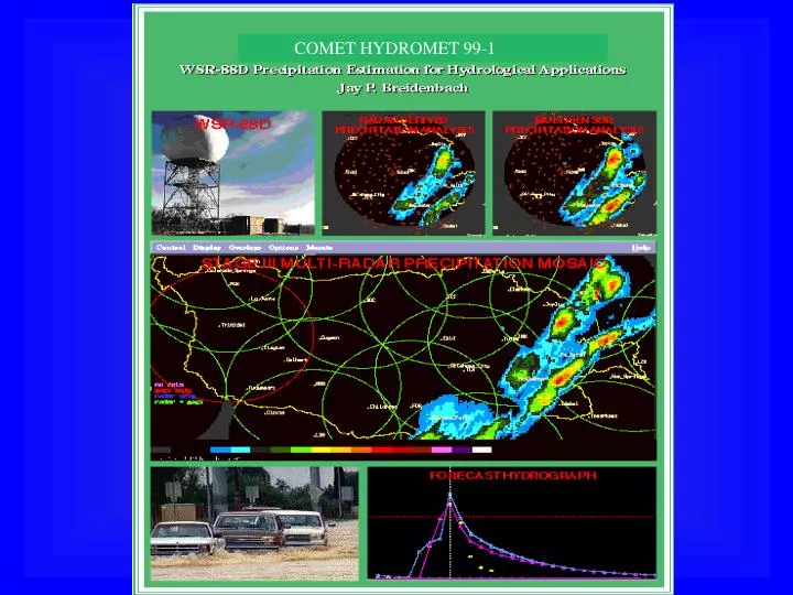
COMET HYDROMET 99-1. Enhancements to PPS. Build 10 (Nov. 1998) Terrain Following Hybrid Scan Graphical Hybrid Scan Adaptable parameters appended to DPA Open Systems RPG Range Correction Mean Field Bias Correction. Radar Precipitation Estimation Stage II and III Processing.

E N D
Enhancements to PPS • Build 10 (Nov. 1998) • Terrain Following Hybrid Scan • Graphical Hybrid Scan • Adaptable parameters appended to DPA • Open Systems RPG • Range Correction • Mean Field Bias Correction
Radar Precipitation Estimation Stage II and III Processing HDP 4 km res. RFC WFO Stage II Stage II Rain gages WHFS/AREA WIDE Stage III
Stage II • Processing for individual radars • 4 km resolution on HRAP grid • 131 x 131 array
Stage II • Mean field bias adjustment • multisensor gage/radar merging • gage only analysis
Stage II processing • Generally run once per hour at H+15 mins for each radar using hourly rainfall ending at H+00 min • Updated every hour to incorporate late arriving gage data by (H+1:15,H+2:15 etc)
Automated QC of HDP Data • Removal of HRAP bin data that are consistently bad (e.g. Mountain blockage or ground clutter contamination) • Removal of bin data contaminated by anomolous propagation (AP) though use of GOES IR satellite and surface temperature data • Removal of outlier bin data (R > threshold)
Mean Field Bias Adjustment • Attempts to account for uniform errors over the entire field such as radar calibration, improper Z-R relationship • Bias is a function of current and previous hours bias • Memory span parameter indicates how many hours to look into the past when determining the current bias
Stage III • Mosaics Stage II multisensor rainfall estimates on to larger HRAP grid • Interactive Quality Control • Can be used as main input into hydrologic models through (MAPX)
Stage III Mosaic • In areas that where more than one radar overlaps forecaster has choice: • mean value of overlapping bins • maximum value of overlapping bins • If multisensor field is not available for a given area, the gage only field is used
Stage III interactive features • Display geographic overlays • Time Lapse • Zoom • Display and Edit Gages • Add pseudo gages • Delete AP • Re-run Stage II and re-mosaic
Important Adaptable Parameters • Memory Span (1-1000) • controls responsiveness of bias adjustment • Indicator Cross Correlation Coefficient (0-1) • controls how good radar verses gage is at indicating where it is raining • Conditional Cross Correlation Coefficient (0-1) • controls how good radar verses gage is at indicating amount of rainfall
Case Study • Site: ABRFC • Study impact of varying adaptable parameters • Vary ICC (0-1) • Vary CCC(0-1) • Compare with 24 hour co-op gages • Compare forecast with observed hydrograph
RFC-WIDE PPS • Mosaic of data from lowest available height • Radar Climatology used to define blocked areas • Satellite and Model Data to delineate clear air AP • No radar data taken from above freezing level used • SOE to fill in missing areas using available gages and surrounding good radar data • PRISM data used to scale estimates in missing areas