Download
1 / 34
340 likes | 428 Views
Resource Stewardship Monitoring Program Riparian Assessment Pilot. Peter J. Tschaplinski Research Branch Ministry of Forests. Forest Districts Participating. Campbell River - DCR Chilcotin - DCH Chilliwack - DCK Kalum - DKM Rocky Mountain - DRM.

E N D
Resource Stewardship Monitoring ProgramRiparian Assessment Pilot PeterJ. TschaplinskiResearch BranchMinistry of Forests
Forest Districts Participating • Campbell River - DCR • Chilcotin - DCH • Chilliwack - DCK • Kalum - DKM • Rocky Mountain - DRM
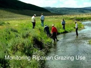
Effectiveness Evaluation Objective for the Fish Value • Determine whether FRPA standards and practices governed by regulation are achieving the desired result of protecting fish values. • includes aquatic ecosystems and adjacent riparian areas • current focus is on streams
Evaluation Approach • Assess physical and biological conditions in streams and their riparian areas • Describe conditions with Routine-Level Checklist covering 14 indicators • Score each Indicator as “Yes = OK” vs. “No = problem” • Roll-up score = overall site condition
Roll-up Scoring System Frequency of “No” Indicators out of 14: 1. Functioning 0 - 2 No’s 2. Functioning, at Risk 3 - 4 No’s 3. Functioning, at High Risk 5 - 6 No’s 4. Non-functioning > 6 No’s
1. Channel bed disturbance 2. Channel bank disturbance 3. LWD processes (jams) 4. Channel morphology 5. Aquatic connectivity 6. Fish cover diversity 7. Moss abundance & condition 8. Fine sediments 9. Aquatic invertebrate diversity 10. Windthrow frequency 11. Riparian soil disturbance 12. LWD supply 13. Shade & microclimate 14. Disturbance-increaser plants Aquatic-Riparian Indicators
RelatingScorestoForestry • This is the hard part. • Explain stream and riparian conditions in terms of required/permitted practices. • Considerations include: 1. Tree retention standards by stream class: RRZs for S1 – S3; RMZs for S4, S5, & S6 2. Riparian ground disturbance, windthrow 3. Roads and road crossings 4. Effects from upstream areas/activities 5. Compare with “undisturbed” conditions (e.g., upstream reference sites)
RSMP Pilot Objectives • Operational test of Routine-Indicator Checklist: • Are the indicators and methods clear, practical, complete? • Do we need additional support: e.g., a field handbook, refresher training, air photos? • What have we missed: Do we need to add indicators/ questions? • Can surveys be done in a time-efficient way? • How easy is it to identify effective forestry practices or to flag problems?
SummaryObservations • Surveys done thoroughly and accurately • Be sure to fill out mandatory information fields:e.g., riparian class, year of harvest • Resources need to be found for data QA to support analyses • The following observations were important for data interpretation: • RMA retention levels (Can be obtained from photos?) • road location, crossing type, road & crossing age (pre-Code, FPC, FRPA) • Results show a mixture of riparian management and road-related effects • Some results complicated by pre-Code and pre-FRPA practices • Surveyors may benefit from a Field Handbook • Recurrent training should be made available when needed