Download
1 / 14
140 likes | 356 Views
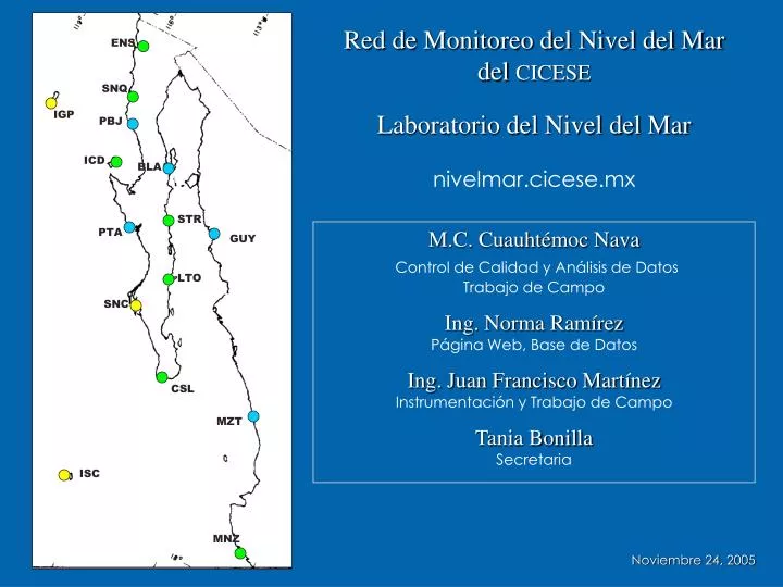
Red de Monitoreo del Nivel del Mar del CICESE. ENS. SNQ. IGP. Laboratorio del Nivel del Mar nivelmar.cicese.mx. PBJ. ICD. BLA. STR. PTA. M.C. Cuauhtémoc Nava Control de Calidad y Análisis de Datos Trabajo de Campo Ing. Norma Ramírez Página Web, Base de Datos

E N D
Red de Monitoreo del Nivel del Mardel CICESE ENS SNQ IGP Laboratorio del Nivel del Marnivelmar.cicese.mx PBJ ICD BLA STR PTA M.C. Cuauhtémoc NavaControl de Calidad y Análisis de DatosTrabajo de Campo Ing. Norma RamírezPágina Web, Base de Datos Ing. Juan Francisco Martínez Instrumentación y Trabajo de Campo Tania BonillaSecretaria GUY LTO SNC CSL MZT ISC MNZ Noviembre 24, 2005
Para qué medir el nivel del mar? • Perspectiva Local • Batimetrías (correciones por marea) • Tablas y Calendarios de marea • Aplicaciones a ingeniería portuaria (APIs), gobierno local, contratistas, etc. • Guía y seguridad de tráfico marítimo (datos tiempo real) • Perspectiva Nacional • Determinación del datum para cartas hidrográficas • Planos de marea Perspectiva Regional • Modelos Numéricos (e.g. Pronóstico de mareas de tormenta) • Perspectiva Internacional • Cambio Global (calentamiento global, aumento del nivel del mar) • Calibración de altimetría por satélite • Circulación Oceánica
GLOSS Tide Gauge • Level accuracy < 1 cm • Timing accuracy < 1 min • Sampling 6 – 15 min averages • Waves filtering • Data recording and automatic transmission • Measurements relative to a “fixed” point • Recommended • CGRS (Continuos GPS Recording System) • Ancillary data (Atm. Press, Tw, Ta, Wind, S%, etc.)
Red de Monitoreo del Nivel del Mar CICESE Estación Mareográfica • Mareógrafo • Sensor • SistemaAdquisiciónDatos • Telemetría • Fuente de Energía • Regla de Mareas • Observador • Bancos de Nivel • ObservadorElectrónico
Red de Monitoreo del Nivel del Mar ENS Colaboración Interinstitucional SNQ IGP PBJ ICD BLA STR PTA GUY LTO SNC CSL MZT ISC CNA, IAI API = Administración Portuaria Integral UH = Universidad de HawaiiSEMAR = SEMAR, México MNZ
ENS Laboratorio del Nivel del Mar SNQ Red de Monitoreo del Nivel del Mardel CICESE IGP PBJ ICD BLA • 7-1 Estaciones Mareográficas Activas • 3 Listas para instalar • 10 En proceso de compra para 2012 • 8 Canales Transmisión Satelital GOES (CNA) 3 Hrs • 5 Canales Transmisión Satelital GOES (CICESE) 1 Hr • 3 Canales Transmisión Satelital GOES (CNA) 5 min • 1 Nivel Leica DNA03 / nivelaciones de 1er orden • 1 Laptop Toshiba (trabajo de campo) • 1 Dell (adquisición automática de datos) • 1 Dell (banco de datos) • 1 Dell (control de calidad, procesado y análisis) • 1 PC (Mareogramas y rollos papel perforado) STR PTA GUY LTO SNC CSL MZT ISC MNZ Noviembre 24, 2005