Download
1 / 31
310 likes | 521 Views
Ideal Gas Law and Winter Weather. Lecture 3 February 8, 2010. Review. Review. *. *. *. *. *. Review from last week. Contouring helps gain a better sense of location and strength of certain past or present weather features Isopleths separate lower values from higher values

E N D
Ideal Gas Lawand Winter Weather Lecture 3 February 8, 2010
Review * * * * *
Review from last week • Contouring helps gain a better sense of location and strength of certain past or present weather features • Isopleths separate lower values from higher values • Contours will never cross each other and never branch or fork. They are always one continuous line. • Do not create contours where there is no data • Contour at evenly-spaced intervals
1012 1008 1024 1020 1020 1016 1024 1028 1016 1016 1024 1020 1016 To convert from Z time to CST, subtract 6 hours. 05Z = 11 PM CST 1012 1012 1020 1020 1016 1012 1012
1024 1016 1020 1016 1024 1020 1016
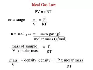
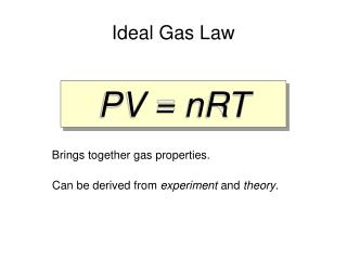
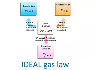
Common Meteorological Variables • Density • Pressure • Temperature • These variables are related by an equation known as the Ideal Gas Law
IDEAL GAS LAW p=ρRT Temperature Pressure Density Gas Constant
DENSITY (ρ) • Density = mass/volume (kg/m3) • Computed by determining the mass of air in a given volume Every side = 1 meter = 1 kg
Which has the greater density? • Box 1: 9 kg / (1 m * 1 m * 1 m) = 9 kg/m3 • Box 2: 3 kg / (1 m * 1 m * 1 m) = 3 kg/m3 Box 1 is more dense
Air molecules decrease with height away from the surface Density decreases with height
PRESSURE (p) • Air molecules are in constant motion and will collide with other air molecules and objects around it. • With each collision, an air molecule exerts a force. • A force is a push or pull exerted from one object to another • Pressure = force / area
If density and temperature decrease with height, pressure must also decrease with height 90% of the earth’s atmosphere is below 10 km
TEMPERATURE (T) • Temperature is a measure of the average kinetic energy of the molecules in a substance (or amount of air) • Kinetic Energy (KE) is a measure of an object’s ability to do work via its motion • KE=½*Mass*Velocity2 • Therefore, faster moving molecules have a higher temperature • Scales, starting with no molecule movement: • Kelvin (K): begins at 0 K, • Celsius (C): begins at -273.15 ºC • Fahrenheit (F): begins at -459.67 ºF
Conversions: K = ºC + 273.15 ºF = (9/5 * ºC) + 32 ºC = 5/9 * (ºF - 32) Records: Low Temp: -128.2 ºF High Temp: 136.4 ºF
Temperature decreases w/ height in the troposphere. • Temperature increases w/ height in the stratosphere. • This is known as an inversion. • Stratosphere warms due to the presence of ozone.
Ice-Crystal Process • The Ice Crystal Process → The Bergeron Process • Cold Clouds • The cloud temperatures allow ice and liquid drops to coexist • Cloud temperature • Warmer than 0°C • → all liquid drops • Colder than 40°C • → all ice crystals • Between 0°C and 40°C • → both ice and water • Water droplets are supercooled
Precipitation Types In a cold cloud, all precipitation begins in the form of snow (ice crystals) • 5 Main Precipitation Types 1. Rain drops of liquid water 2. Snow ice crystals 3. Sleet frozen rain drops 4. Freezing Rain rain the freezes on contact with a cold surface 5. Hail large pieces of ice How do we get this variety if the origin of the precipitation is the same?
Temperature is Key • The vertical distribution of temperature will often determine the typeof precipitation that occurs at the surface • As we have learned before, temperature typically decreases with height in the atmosphere • But, in winter, temperature inversions can be critical in determining the type or types of precipitation
Snow • The surface temperature is 25°F (-4°C) and increases with height before decreasing. • However, since the temperature remains below freezing at every height, any precipitation that falls will remain as snow. http://www.srh.noaa.gov/jetstream//synoptic/precip.htm
http://okfirst.mesonet.org/train/materials/Winter/snow-sounding.jpghttp://okfirst.mesonet.org/train/materials/Winter/snow-sounding.jpg
Sleet • Surface is below freezing • As elevation increases, the temperature increases to a point where some of the atmosphere is above freezing • As snow falls into the layer of air where the temperature is above freezing, the snow flakes partially melt. • As the precipitation reenters the air that is below freezing, the precipitation will re-freeze into ice pellets that bounce off the ground, commonly called sleet. http://www.srh.noaa.gov/jetstream//synoptic/precip.htm
Freezing Rain • Will occur if the warm layer in the atmosphere is deep with only a shallow layer of below freezing air at the surface. • The precipitation can begin as either rain and/or snow but becomes all rain in the warm layer. • The rain falls back into the air that is below freezing but since the depth is shallow, the rain does not have time to freeze into sleet. • Upon hitting the ground or objects such as bridges and vehicles, the rain freezes on contact. • Some of the most disastrous winter weather storms are due primarily to freezing rain. http://www.srh.noaa.gov/jetstream//synoptic/precip.htm
Flurries - Light snow falling for short durations. No accumulation or light dusting • Showers - Snow falling at varying intensities for brief periods of time. Some accumulation is possible. • Squalls - Brief, intense snow showers accompanied by strong, gusty winds. Accumulation may be significant. Snow squalls are best known in the Great Lakes region. • Blowing Snow - Wind-driven snow that reduces visibility and causes significant drifting. • Blizzard - Winds over 35 mph with snow and blowing snow reducing visibility to less than ¼ mi.
Lake-effect Snow • Lake-effect snow is produced when cold winds move across warmer lake water and pick up the lake’s moisture • As the water vapor freezes and condenses into snow, it is deposited on the windward shores. • Produces narrow, but very intense bands of precipitation • Can snow at a rate of many inches per hour • Occurs most frequently near the Great Lakes
Lake-effect Snow on RadarBuffalo, NY (KBUF) - October 12, 2006
Blizzards • Severe winter storm characterized by low temperatures, strong winds greater than 35 mph, heavy blowing snow, and visibilities less than ¼ mile, lasting for 3 hours or more • Storm systems powerful enough to cause blizzards usually form when the jet stream dips far to the south. • This allows cold air form the north to clash with warm air from the south. • Blizzard conditions usually develop on the NW side of these storm systems
Nor’easters • Among winter’s nastiest storms • Derives its name from its continuously strong northeasterly winds blowing in from the ocean ahead of the storm • Strong areas of low pressure that form in the Gulf of Mexico or off the East Coast in the Atlantic and move up the coast • Produce heavy snow, rain, oversized waves, and winds that sometimes exceed hurricane force in intensity