Download
1 / 2

E N D
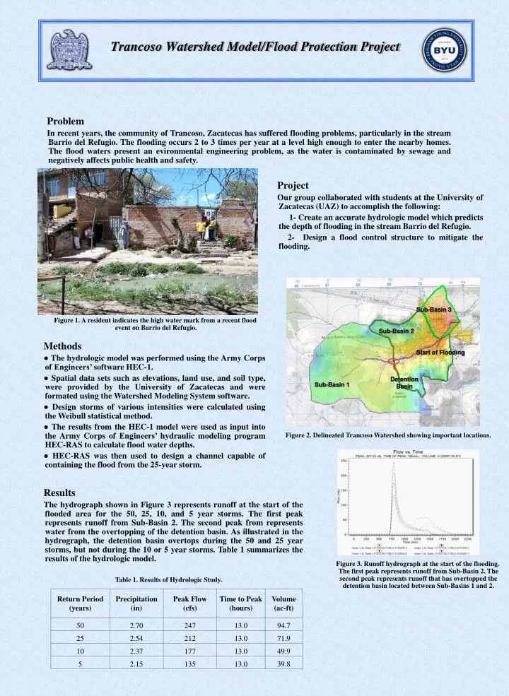
Problem In recent years, the community of Trancoso, Zacatecas has suffered flooding problems, particularly in the stream Barrio del Refugio. The flooding occurs 2 to 3 times per year at a level high enough to enter the nearby homes. The flood waters present an evironmental engineering problem, as the water is contaminated by sewage and negatively affects public health and safety. Project Our group collaborated with students at the University of Zacatecas (UAZ) to accomplish the following: 1- Create an accurate hydrologic model which predicts the depth of flooding in the stream Barrio del Refugio. 2- Design a flood control structure to mitigate the flooding. Trancoso Watershed Model/Flood Protection Project Sub-Basin 3 Figure 1. A resident indicates the high water mark from a recent flood event on Barrio del Refugio. Sub-Basin 2 Methods ● The hydrologic model was performed using the Army Corps of Engineers’ software HEC-1. ●Spatial data sets such as elevations, land use, and soil type, were provided by the University of Zacatecas and were formated using the Watershed Modeling System software. ●Design storms of various intensities were calculated using the Weibull statistical method. ●The results from the HEC-1 model were used as input into the Army Corps of Engineers’ hydraulic modeling program HEC-RAS to calculate flood water depths. ●HEC-RAS was then used to design a channel capable of containing the flood from the 25-year storm. Start of Flooding Detention Basin Sub-Basin 1 Figure 2. Delineated Trancoso Watershed showing important locations. Results The hydrograph shown in Figure 3 represents runoff at the start of the flooded area for the 50, 25, 10, and 5 year storms. The first peak represents runoff from Sub-Basin 2. The second peak from represents water from the overtopping of the detention basin. As illustrated in the hydrograph, the detention basin overtops during the 50 and 25 year storms, but not during the 10 or 5 year storms. Table 1 summarizes the results of the hydrologic model. Figure 3. Runoff hydrograph at the start of the flooding. The first peak represents runoff from Sub-Basin 2. The second peak represents runoff that has overtopped the detention basin located between Sub-Basins 1 and 2. Table 1. Results of Hydrologic Study.
Trancoso Watershed Model/Flood Protection Project 2185 2180 2164.4 2164.2 2164.0 2175 Elevation (m) 2163.8 Elevation (m) 2163.6 2170 2163.4 2163.2 2165 2163.0 0 1 2 3 4 5 Station (m) 2160 200 400 600 800 1000 1200 Channel Distance (m) Channel Design A channel was designed to contain the peak flow from the 25-year storm. Multiple channel sizes, shapes, and slopes were run through HEC-RAS to find a preferred channel design. Engineering Disciplines This project included the following engineering discplines: 1- Water Resorces. Calculating the quantity of water of the flood water depths. 2- Geotechnical. Reading soils maps that indicate soil composition and assigning a corresponding hydrologic soil type. 3- Transportation. The current wash is used as a pedestrian walkway. The proposed channel leaves enough room on both sides of the channel to allow pedestrian passage. Realistic Constraints This project included the following constraints: 1- Economic. The Mexican city of Trancoso does not have much funding for civil engineering projects. A more complete solution, including a second detention basin at the start of the flooding zone, is not feasible, because of the high cost of re-routing roads or removing buildings. 2- Social/Cultural. The homes on either side of the channel are in the 5-year floodplain. The most effective way to mitigate such a flooding problem would be to exercise eminent domain to buy the homes then relocate the residents. The homes are of low quality and are already badly damaged by reoccuring floods. This option, though logical, did not fit within the social/cultural constraints of Mexico. One Mexican government disaster responder expalined that if the government relocates the people to new houses, the people would sell them and move back to the old abandoned houses near the dry stream. For this reason, our design solution could not relocate a single home. Hydraulic Model Results The following figure shows the level of the flood waters given a 5, 10, 25, and 50 year storm at peak flow. As seen, the 50 years storm experiences flood water depths as high as 2.5 meters. The surface was generated using survey data. In most places, the channel is 20 to 30 meters wide, though in a few places it is smaller.

![Flood Risk Review Meeting: [Watershed Name]](https://cdn1.slideserve.com/2624189/flood-risk-review-meeting-watershed-name-dt.jpg)

![Flood Risk Review Meeting: [Watershed Name]](https://cdn2.slideserve.com/3807999/flood-risk-review-meeting-watershed-name-dt.jpg)