Download
1 / 27
270 likes | 392 Views
How to Put GIS To Work for Voting Redistricting. Spring NEARC - May 22, 2012 - Smith College. Michele Giorgianni, GISP Project Manager. Empowering People with Spatial Solutions. www.AppGeo.com. Agenda. Background Methods Data Prep Create Proposals Street List Lessons Learned.

E N D
How to Put GIS To Work for Voting Redistricting Spring NEARC - May 22, 2012 - Smith College Michele Giorgianni, GISP Project Manager Empowering People with Spatial Solutions www.AppGeo.com
Agenda • Background • Methods • Data Prep • Create Proposals • Street List • Lessons Learned
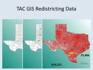
Background • New 2010 Census data • New State and US districts • State Representative (House) • State Senate • US Congressional • Drives new local districts • Voting districts/precincts • Town Council districts/wards • Potentially others (School, Water, Special…) • Case Studies • Lincoln/Cumberland RI • West Hartford CT
Methods – Data Prep • New State/US districts • CT published online for download • RI didn’t distribute publically – only to towns
Methods – Data Prep • Existing Local Districts • Obtain existing local district layers And/Or • Convert existing maps • Start by coding census blocks with district numbers
Methods – Data Prep • Geocoding • Obtain list of Registered Voters, Polling Locations, Commissioners/officials • Prep into tabular format for geocoding
Methods – Data Prep • Geocoding • Composite Address Locators • RI: e911 Sites & e911 Roads • CT: address points & roads
Methods – Data Prep • Voters • Voter points by precinct • Spatial Join
Methods - Data Prep • Voters • Summary Statistics on district • Create pivot table if labeling multiple parameters • Join to display voter counts on map
Methods – Data Prep • Create map(s) of existing conditions • Town can work with it
Methods – Create Proposal(s) • Workshop with Town Staff • Mark up maps interactively • Pay attention to… • New State boundaries • Potential to merge districts • Keep a polling location in each district • Don’t move official out of district • Registered voter count (ex: RI < 3000) • Council district population balanced
Methods – Create Proposal(s) • Create proposed layer(s) from Census Blocks • Code each block w/ district number(s) • Try not to split across blocks if can be avoided Adjust council boundary to follow block boundaries along the north side Have to split block to keep Wake Robin Condo Complex voters in council district 4 (north)
Methods – Create Proposal(s) • Handling split blocks (only when absolutely necessary ) • Proportion population • Code all whole blocks fully • Make feature layer • Enable Ratio Policy on population field
Methods – Create Proposal(s) • Split blocks by Union • Ex: with council layer from dissolved blocks with cuts already made
Methods – Create Proposal(s) • Calculate new counts for proposed districts • Voters again (same steps as before) • Population (council) • Summarize District field for Pop Sum in Unioned block layer
Methods – Create Proposal(s) • Display all on proposal map
Methods – Street List • States require table for import into their database • Include all potential addresses, not just voters • Address ranges on streets by district
Methods – Street List • Need Census Geography – Faces and Edges
Methods – Street List • Census Faces and Edges • A census block may consist of one or more faces • Faces: • Unique identifier: TFID • Edges: • Unique identifier: TLID • Order of the nodes defines the From-To orientation and left/right sides of the edge • Each Edge specifies which face (identified by TFID) is on its… • right with the TFIDRfield • left with the TFIDLfield • With this knowledge we can now… • Code the Faces with the districts (union) • Code the Edges with left/right districts Face Edge Face
Methods – Street List • Use model builder and/or python scripting • West Hartford – just model builder • Didn’t aggregate down to the “All” • Left each segment as a record in final output table – each Even and Odd • Didn’t aggregate consecutive segments ranges to single high-low range
Methods – Street List • Python scripting handled aggregations • RI: started w/ model, moved to python after many crashes • Final output table has roads aggregated as much as possible, but still not perfect
Lessons Learned • Geocoding • Need good reference data • Need clean source address table • Can spend a lot of time reviewing/placing unmatched • Census Data • Street Names • Some are just missing • Some are just wrong • Check: join voter list & local road layer street names to census streets names (both directions) – identify/fix mismatches • Missing address ranges • Edges missing zip codes if no range • Populate from associated faces
Lessons Learned • Example: Missing Address Ranges
Lessons Learned • Example: What side is District on if no range?
Lessons Learned • Example: Dealing with edges at split blocks = headache
Thank You Michele Giorgianni, GISP Project Manager mgiorgianni@appgeo.com 860-643-4401 x304 Special thanks to: Maria Giarrusso, City of Cranston, RI For pointing me to the Faces and Edges!