Download
1 / 1
10 likes | 91 Views
Drainage Network and Watershed Reconstruction on Simplified Terrain. Jonathan Muckell a , W. Randolph Franklin a , Marcus Andrade b , Barbara Cutler c , Metin Inanc c , Zhongyi Xie c , Daniel M Tracy c.

E N D
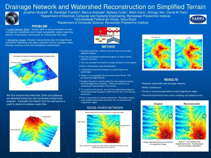
Drainage Network and Watershed Reconstruction on Simplified Terrain Jonathan Muckella, W. Randolph Franklina, Marcus Andradeb, Barbara Cutlerc, Metin Inancc, Zhongyi Xiec, Daniel M Tracyc aDepartment of Electrical, Computer and Systems Engineering, Rensselaer Polytechnic Institute bUniversidade Federal de Vicosa, Visco Brazil cDepartment of Computer Science, Rensselaer Polytechnic Institute • PROBLEM • Large Dataset Sizes: Terrain data is being sampled at ever increasing resolutions over larger geographic areas requiring special compression techniques to manipulate the data • Sampling Issues: Dataset inaccuracies due to insignificant resolution sampling and data collection errors impedes water flowing causing small and unrealistic watersheds. • METHOD • Compute Initial Flow. Where every cell flows to the lowest adjacent neighbor. • Very fast connected components program is used to detect plateaus and sinks • We use a breadth first search to assign directions to flat regions • Flow is recomputed using new directions • Connected components program is used to determine watersheds • Steps 1-5 are repeated for the inverse of the Terrain. This provides the Ridge Network • Douglas-Peucker is used to select the most significant points from the Ridge-River networks. These are stored as our compressed representation of the terrain. • To reconstruct the terrain we use Over-determined Laplacian Partial Deferential Equations (ODETLAP) to “fill in” the missing data points • Flow is computed on reconstructed terrain. Resulting in fewer, more realistic watersheds since flow can run passed small insignificant ridges. RESULTS • Realistic watersheds and drainage networks • Better compression • Terrain is reconstructed without small insignificant ridges • Reconstructed terrain fixes some sampling and dataset errors. We first compute the initial flow. Sinks and plateaus are detected using very fast connected components program. A breadth-first search from the spill points is used to determine plateau water flow. RIDGE-RIVER NETWORK