Download
1 / 8
80 likes | 261 Views
Free and Open Source GIS Applications in Environmental Modeling. Daniel P. Ames, PhD, PE Assistant Professor, Dept of Geosciences GIS Graduate Program Director Team Leader, MapWindow GIS Project Idaho State University – Idaho Falls. What is “Open Source”?. “The last bastion of Stalinism…”

E N D
Free and Open Source GIS Applications in Environmental Modeling Daniel P. Ames, PhD, PE Assistant Professor, Dept of Geosciences GIS Graduate Program Director Team Leader, MapWindow GIS Project Idaho State University – Idaho Falls
What is “Open Source”? • “The last bastion of Stalinism…” • Multi-billion dollar industry including servers (20% of all servers are Linux), databases (MySQL will double its revenue to $80 M this year), development platforms (Eclipse has eclipsed nearly all other programming environments) and thousands of open source projects on www.SourceForge.net and elsewhere. • “It’s OK for playing around, but when you really have to do work, you use commercial product X” • “When programmers can read, redistribute, and modify the source code for a piece of software, the software evolves. People improve it, people adapt it, people fix bugs. And this can happen at a speed that, if one is used to the slow pace of conventional software development, seems astonishing.”- www.OpenSource.org
Some Open GIS Organizations • OGC = Open Geospatial Consortium • Evolved from GRASS Foundation • Sponsored by open and closed source companies • Focused on development of open standards – especially for web services (WFS, WCS, WMS, etc.) • OSGeo = Open Source Geospatial Foundation • New organization focused on supporting and promoting open source geospatial software • Sponsors FOSS4g Conferences (first was last year in Lausanne, Switzerland!)
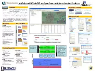
B A C Meteorological Data D Landuse Distribution E HSPF HSPF Stream Data F Complex Models in BASINS Landuse and pollutant specific Data Landscape data Point Sources Windows interface GIS Core Model Post Processing Courtesy of Tetra Tech Inc.
Acknowledgements • Dan Ames, Chris Michaelis, Allen Anselmo, Lailin Chen, Ted Dunsford, Jeyakanthan Veluppillai, Chris Forsgren, Nathan Arave, Angela Hillier, Nancy Glenn, Richard Inouye – Idaho State University • David Stevens, David Tarboton, Jeff Horsburgh, Bethany Neilson, Connely Baldwin, Mac McKee, Thom Hardy – Utah State University • Paul B. Duda, John L. Kittle, Jr., Mark H. Gray, Paul R. Hummel – Aqua Terra Consultants • Shane Cherry, Randy Lee, Ron Rope, Bob Breckenridge – Idaho National Laboratory • Russell S. Kinerson, Paul Cocca, David Wells, Marjorie Wellman, Ed Partington, Lauren MacWilliams – EPA Office of Science and Technology • Gerry Laniak, Kurt Wolfe – EPA Ecosystems Research Division – Athens, GA