Download
1 / 16
160 likes | 461 Views
Regions of Texas Lesson Plan. Jill Kunkel December 12, 2013 Texas Woman’s University. Introduction.

E N D
Regions of Texas Lesson Plan Jill Kunkel December 12, 2013 Texas Woman’s University
Introduction • The purpose of this lesson is to introduce and familiarize fourth grade students with the regions of Texas through map exploration while becoming familiar with characteristics associated with each region such as: economic development, human adaptations to environment, population distribution, resources, landform, and climate. • This lesson will implement a differentiated instructional approach through various lesson plan modifications in content, process, and product. For content, the lesson will be adapted to provide a variety of materials including visual images, electronic & print books, brochures, music, and film. For content delivery, various approaches including whole class discussion, small group cooperative work, oral lectures, watching a visual presentation, small group-teacher interaction, and kinesthetic demonstration will be implemented. Modifications in process include providing a variety of learning centers with flexible grouping. Lastly, product will be modified by providing various assignments including writings, presentations, quizzes, and drawings as ways to assess understanding.
Theme & Topic • Grade: Fourth grade • Subject: Social Studies • Topic: Exploring the regions of Texas • Duration: Approx. 6 days, 35 minutes/day
Content Objectives • Given a whole class discussion and Power Point display of detailed map of the regions of Texas, students will list the regions of Texas and memorize region location and landform such as flat, mountains, and valleys. • Given a power point display of the regions, rivers, and cities of Texas with letters written instead of the name and a worksheet with the names, students will locate and select which letter matches which city, river, or region with 80 percent accuracy. • Given a textbook with a map of the regions of Texas and a worksheet with a Texas outline, students will sketch the textbook map onto their worksheet including all major rivers, major cities, and shading the regions of Texas with different colors. • Given a variety of learning centers organized by region for students to explore and a fill in the blank paper, students will compare differences by writing down one of each descriptive characteristic of population, resource, economic climate, and landform for every region of Texas. • Given a peer partner, students will select a region of interest to further evaluate and present to the classroom. • Given access to PowerPoint, students will create a slideshow based on their selected region along with rivers or major cities in the region, population, climate, resources, and economic information.
Language Objectives • Paired into groups and given a textbook map, students will meaningfully speak , practicing pronunciation, to one another as they define and list the regions of Texas onto piece of paper. • Given a visual cue such as the map of Texas, students will locate the regions, cities, and rivers of Texas and draw/write a map of their own onto a blank Texas outline paper. • Given a variety of learning centers organized by region, students will have visual and contextual support from peers and the teacher to enhance understanding of language structures and vocabulary. • Given brochures, biographies, and books, students will read aloud during a small group-teacher interaction. • Given a journal, students will choose one region of Texas which is similar or differs from their native country and will write a comparison entry on how their native country relates or differs from the population, climate, landform, resources, and economics of the selected region of Texas; therefore, engaging background knowledge. • Paired into groups, students will communicate meaningfully and practice pronunciation as they construct their region of Texas poster board presentation.
TEKS • (6) Geography. The student uses geographic tools to collect, analyze, and interpret data. The student is expected to: • (A) apply geographic tools, including grid systems, legends, symbols, scales, and compass roses, to construct and interpret maps; and • (B) translate geographic data, population distribution, and natural resources into a variety of formats such as graphs and maps. • (7) Geography. The student understands the concept of regions. The student is expected to: • (A) describe a variety of regions in Texas and the United States such as political, population, and economic regions that result from patterns of human activity;
TEKS • (B) identify, locate, and compare the geographic regions of Texas (Mountains and Basins, Great Plains, North Central Plains, Coastal Plains), including their landforms, climate, and vegetation; and • (C) compare the geographic regions of Texas (Mountains and Basins, Great Plains, North Central Plains, Coastal Plains) with regions of the United States and other parts of the world. • (9) Geography. The student understands how people adapt to and modify their environment. The student is expected to: • (A) describe ways people have adapted to and modified their environment in Texas, past and present, such as timber clearing, agricultural production, wetlands drainage, energy production, and construction of dams;
English Language Standards • 1. (E) internalize new basic and academic language by using and reusing it in meaningful ways in speaking and writing activities that build concept and language attainment; • 3. (E) share information in cooperative learning interactions • 4. (D) use pre-reading supports such as graphic organizers, illustrations, and pre-taught topic-related vocabulary and other pre-reading activities to enhance comprehension of written text; • 4. (F) use visual and contextual support and support from peers and teachers to read grade-appropriate content area text, enhance and confirm understanding, and develop vocabulary, grasp of language structures, and background knowledge needed to comprehend increasingly challenging language; • 4. (G) demonstrate comprehension of increasingly complex English by participating in shared reading, retelling or summarizing material, responding to questions, and taking notes commensurate with content area and grade level needs;
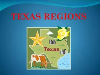
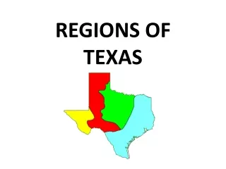
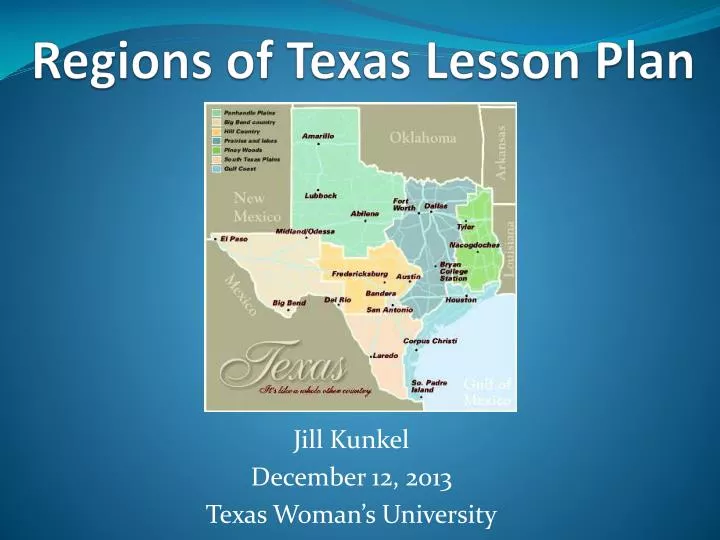
Step by Step Procedure • Day 1: • Teacher will introduce the topic of the week and state clear expectations/objectives to students. • Students are expected to complete activities and assignments • Students are expected to come to class prepared, utilize listening and communicative skills, and read provided materials. • Using PowerPoint, the teacher will display a map of Texas labeled with four regions (Great Plains, Mountains & Basins, Central plains, Coastal Plains), major cities (Dallas, Austin, Houston Amarillo, Galveston, El Paso, San Antonio, Waco, Odessa) and rivers (Trinity, Brazos, Colorado, Guadalupe, Nueces and Pecos). • As a whole class discussion, the teacher will introduce the new content words of the regions while defining the words. For example, Mountains & Basins-The teacher will tell the class what a basin is by relating the new vocabulary word to the household item: the sink (also known as a basin). With visual pictures included on the PowerPoint presentation, the teacher will show the students what a Mountain and Basin look like. • The students will be asked to speak to a neighbor for 3 minutes about what they see in their surroundings and/or places they’ve been or lived. • After the discussion, the teacher will continue explaining how to read the key on the map by pointing and demonstrating on the PowerPoint. The teacher will ask engaging questions to the students during the discussion to create an interactive learning experience. • Concluding, the teacher will let the students know they will draw their own map tomorrow and would like the students to write 2 paragraphs about what they learned about Texas.
Step by Step Procedure • Day 2: • The teacher will begin by purposely creating heterogenous smalls groups composed of varying readiness levels, ELLs, and native-English speaking students. Then, hand out copies of a Texas outline to each student. • Students will take out colored pencils and a writing pencil. • Each student will have a textbook with a map of Texas for reference. • The teacher will state clear student expectations: • Students will first label and color the four different regions • Then the students will draw rivers with names labeled, and dots for cities labeled. • The students will include a map key on their paper. • Students will work cooperatively with group members, sharing ideas and helping others when needed. • To wrap up the days lesson, the teacher will tell the students they will be participating in learning centers with different regions highlighted the following day.
Step By Step Procedure • Day 3 • The teacher will organize four different interactive learning stations: • Station 1: Mountains & Basins • Station 2: Great Plains • Station 3: Coastal Plains • Station 4: Central Plains • Each learning station will include pictures of the land and people who live there, major city located in the region, brochure of town located in the region, common hobbies, a short factual book about the region, demographic information, and list of economic resources. Each learning station will have a labtop/computer with a clip of the popular music from the area and 1-2 minute video clip of the region. • Students will be paired into a different group from the previous day. This group will be homogenous including those of similar readiness levels, interests, and learning profiles. • Students will come into class, be assigned group, then go to learning station. The students will spend 7 minutes at each learning station and will take turns using the resources at each station. While exploring, students will take notes writing down characteristics of each region. After 7 minutes, students will return resources back to their original spot and move to the right. • At the end of the lesson, the students will be told they will have a quick quiz regarding locating regions, cities, and rivers on the map in the morning then discuss a group project.
Step By Step Procedure • Day 4 • On the quiz will be the State of Texas with unlabeled rivers, regions, and cities that were previously discussed. Instead of the labeled word on the map, a letter will replace it. The students will have a list of names with a small blank in front of it for the student to write the letter which matches the name. The students will come into class and have 10 minutes to take the quiz. • After the quiz, the teacher will discuss the group project. • Students will choose a specific region of Texas to highlight during a presentation to the class • Students will decorate a poster board with an illustration of their region on a map while also including information about climate, economic resources, population, local hobbies, and major cities in the region. • Students will be purposely grouped into heterogeneous groups based on varying levels of readiness, interests, native language and learning profiles. • During the rest of the allotted class time, students will be able to use a computer to research information about their selected region, check out a book from the library about the region, or use classroom resources from the learning centers that will be set up still. • 5 minutes prior to the ending of the class, the teacher will tell the students the next day activities will include research and making of the PowerPoint.
Step By Step Procedure • Day 5 • Students will continue researching information about their region. • Students will use classroom time to finish Power Point slide. • Students will write in journal the last 7 minutes of class. Journal topic will include: compare the region where you are from or live to the region you are researching. Describe differences and similarities. • Day 6 • When completed, students will present their PowerPoint to the class sharing the newly learned information. Presentation will last 3-7 minutes.
Materials • Colored pencils and writing utensil • Texas outline worksheets (1/ea. student) • Quiz sheet (1/ea. student) • Journal for each student • SmartBoard to display PowerPoint • Notebook paper (2-3 pieces for each student for taking notes) • History/Geography Textbook • 4 learning centers (Mountains & Basins, Central Plains, Coastal Plains, Great Plains): • 4 brochures (1 for each station) • 4 music clips on the classroom computer • 4 short film clips on the classroom computer • 4 short books (1 for each station) • 3 pictures of region at each station • List of economic resources, demographic information, and hobbies at ea. station.
Assessment • Utilizing a differentiated approach, assessments will be conducted using a variety of assignments allowing students to demonstrate understanding in multiple ways. • During the whole class discussion, I will observe students knowledge by asking questions regarding the regions of Texas. • I will assess understanding through two journal entries • One quiz will be given • In-class group assignment: Students decorate and label regions, major cities, and major rivers of Texas. • Students PowerPoint will be assessed by using a checklist. • Students presentation will be assessed by using a checklist. • Composition of in class assignment and quiz will be added to students portfolio.
Conclusion • Through utilizing a differentiated approach, I provided various forms of content and delivery methods. In the learning centers, brochures, music clips, visual images, peers, film clips, and books were provided to engage the learner. In addition, I presented instruction using an interactive whole class discussion with visual images and introductory to new vocabulary words. I demonstrated how to read a map and locate areas on a map. During this discussion, I demonstrated pronunciation of new words and allowed the students time to discuss their ideas with peers and practice pronunciation. • Modifying the process involved making adaptations to how the student learned the knowledge being presented. I modified the process by offering flexible grouping and learning centers. Students were encouraged to cooperatively work with other students during multiple assignments while also had time for independent work through journal entries. • Assessment was continuous and offered various ways for students to demonstrate knowledge. A replica Texas map, journal entries, quiz, and presentations were all methods of assessments which allowed students to display understanding, areas of improvement, and/or interests.