Download
1 / 26
260 likes | 265 Views
Innovative Approaches for Addressing Floods. Katie Hirschboeck & Kate Sammler Laboratory of Tree-Ring Research Tree-Ring Day Earth Science Week March 29, 2010. Hirschboeck Research Themes:. The “HIRSCHBO” LAB. How are climate patterns & daily weather maps linked?.

E N D
Innovative Approaches for Addressing Floods Katie Hirschboeck & Kate Sammler Laboratory of Tree-Ring Research Tree-Ring Day Earth Science Week March 29, 2010
The “HIRSCHBO” LAB How are climate patterns & daily weather maps linked? How can I remove these trees? How would I classify THIS flood!? Why do people drive into flooded washes? Ela Czyzowska Ph.D. Program Arid Lands ResourcesSciences Kate SammlerPh.D. ProgramSchool of Geography& Development Jennifer (Welti) LeeM.S. Atmospheric Sciences in absentiaNational Weather Service Forecaster, Hunstville AL Co-advising with Holly Hartmann: Jeannette EstesM.S. Hydrology & Water Resources Ongoing collaboration: Ashley ColesPh.D. ProgramUA School of Geography& Development Volunteer: Nazanin Babamarandi Formerly: Iran MeteorologicalOrganization
Beyond “Cuisinart” Hydrology: Innovative Approaches for Addressing Floods Katie Hirschboeck & Kate Sammler Laboratory of Tree-Ring Research Tree-Ring Day Earth Science Week March 29, 2010
EXTREME MAKEOVER: Southwest Climate Edition
Statistically, EXTREME EVENTS are phenomena of the Lower & Upper Tails of Skewed Probability Distributions . . . How can water managers better deal with events in the “tails” of streamflow probability distributions — both floods & droughts? . . . By moving beyond conventional approaches . . . .
For WESTERN WATER MANAGERS : Tree-Ring StreamflowReconstructions . . . . . . are compelling benchmarks that aid in planning for future extreme LOW FLOW conditions using : -- tree-ring reconstructions -- simulations -- scenario-building -- climate projection modeling Water supply simulation based on extreme low flow sequences in the paleo-record STREAMFLOW RECONSTRUCTION for 1330-2005
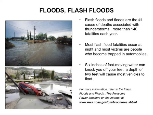
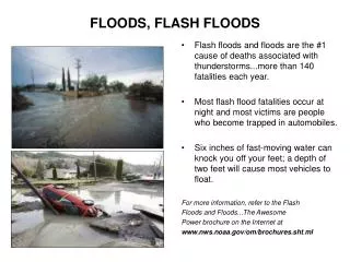
In contrast . . . FLOOD & WATERSHED MANAGERS are far more constrained in the ways they can incorporate climate change information operationally. This is due to . . . . -- existing flood management policy and practices 100-Year Flood Hazard Area • -- the extreme, short-term, localized, and weather-based nature of flooding . . . . Photo by Ashley Coles
and . . . -- inconclusive evidence for increases in extreme flooding in the U.S. : “ There is no evidence of widespread or systematic increases in peak streamflows, although there is widespread evidence of increases occurring in annual low flows.” Lins ( 2005) see also: Douglas et al., 2000; Lins and Slack 2005 LAND USE CHANGES = perceived as the more important issue
A Workshop on Global Change and Extreme Hydrologic Events: Testing Conventional Wisdom January 5, 2010 - January 6, 2010 Committee on Hydrologic Sciences National Academy of Sciences
What’s Needed: Information presented in an operationally useful formatfor flood & watershed managers which describes how changes in the large-scale climatic “drivers” of hydrometeorological extremes will affect flooding variability in SPECIFIC WATERSHEDS
FLOOD-CAUSING DRIVERS & MECHANISMS Meteorological & climatological flood-producing mechanisms operate at varying temporal and spatial scales
Can we find out more about what drives this history of flooding? What does it look like when classified hydroclimatically? What kinds of storms produced the biggest floods?
FLOOD HYDROCLIMATOLOGY = classifying each flood in the record according to cause
Current practice analyzes floods using “CUISINART”HYDROLOGY! “FLOOD PROCESSOR” With expanded feed tube – for entering all kinds of flood data including steel chopping, slicing & grating blades– for removing unique physical characteristics, climatic information, and outliersplus plastic mixing blade – to mix the populations together
Moving Beyond “Cuisinart” Hydrology . . . . A Mixture of Flood Causes: Data from key flood subgroups may be better for estimating the probability and type of extremely rare floods than a single “100-Year Flood” calculated from all the flood data combined! -- Useful for defining regions; -- Can then be used to estimate flow behavior in ungaged basins (new USGS collaboration)
FLOOD • HYDROCLIMATOLOGY: • (1) Different types of FLOODS • (2) Different types ofSEASONAL FLOW REGIMES Tropical Storm -related Wintersynoptic (extreme ) Winter synoptic (moderate) Summer convective
ConceptualEcological Modelfor a SouthwesternRiver Ecosystem Flow regime is of central importance in sustainingthe ecological integrity of flowing water systems From: Haney (2007) Southwest Hydrology
Ecosystem Services Analysis of Climate Change and Urban Growth in the Upper Santa Cruz Watershed; the Santa Cruz Watershed Ecosystem Portfolio Model (SCWEPM) A decision support tool to mimic ecosystem services and alternative scenarios based on predictions of urban development and climate change .
Flood Hydroclimatology Database Based on USGS “peaks-above-base” record (annual & partial series) PURPOSE: to determine hydroclimatic context for causes of floods in AZ watersheds
Increasingly Important Research Needs: Model runs to link surface hydrology with scenario-driven atmospheric circulation • DOWNSCALING • -- clearly communicate accuracy in downscaled model results • -- don’t oversell the degree of precision • -- “scaling up from local data is as important as scaling down from globally forced regional models.” • -- regionally tailored indices may be better than the latest “index-de-jour” • Coupled with PROCESS-SENSITIVE UPSCALING Process studies at the watershed scale to specify climate linkages
WHAT WILL THE FUTURE HOLD? . . . will climatic change make floods more extreme? more frequent? or will they get smaller? more frequent? less frequent?
Some Important Flood-Generating Tropical Storms Tropical storm Octave Oct 1983 (2) A Change in Frequency or Intensity of Tropical Storms? (1) A Northward Shift in Winter Storm Track? Roosevelt Dam Jan 1993 Winter flooding on Rillito in Tucson (3) A More Intense Summer Monsoon? RillitoJuly 2006