Download
1 / 22
220 likes | 309 Views
Channel and Habitat Monitoring in the Countyline Reach of the Lower White River. Presented by Sarah McCarthy and Terry Butler River and Floodplain Management Section King County Water and Land Resources Division November 01, 2012 King County Science Seminar. Monitoring Questions.

E N D
Channel and Habitat Monitoring in the Countyline Reach of the Lower White River Presented by Sarah McCarthy and Terry Butler River and Floodplain Management Section King County Water and Land Resources Division November 01, 2012 King County Science Seminar
Monitoring Questions Implementation Monitoring Project Effectiveness Monitoring Have the projects: Met the design specifications? Improved riverine processes and functions? Reduced or maintained current levels of flood risk? Reduced the need for remedial actions?
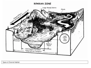
Project Effectiveness Monitoring Categories Channel Dynamics Aquatic Habitat Riparian Processes Fish & Amphibians Flood Risk
White River Setting Green R MMD White R White River Alluvial Fan County- line Reach Buckley Countyline Reach Auburn Source: Chris Brummer
1914 Historical Channels 1931-2000; 2010 Aerial Countyline Channel 1914 to Present
Predicted Left Bank Post-Project Channel and Floodplain Evolution
LiDAR Imagery, Cross Sections Change in Gravel Bar Elevations (2007-09) by Comparison of DEMs
Substrate Particle Size Distributions White RM 0.0 to 10.6, including Countyline Reach. 2009 Data Source: Czuba et al. (2010)
Cross Section Data: Volumes, Rates and Elevation Calculations Example Surveyed Cross Section in Countyline Reach Reach-Averaged Rate of Change in Riverbed Elevation (feet/year) Change in Water Surface Elevation, 2009 to 2011, at 5000 cfs Hydraulic Modeling In 1-D HEC-RAS
Acknowledgements Monitoring Plan Authors: Sarah McCarthy, Josh Latterell, Terry Butler, Jo Wilhelm, Hans Berge, Chris Brummer Data Collection and Analysis: Kate Akyuz, Josh Latterell, Dan Lantz, Chris Gregersen, Chris Knutson, Jim Lissa, Jo Wilhelm, Ray Timm, Kyle Comanor, Fred Lott, Bob Black (USGS), Steve Damm (USFWS), Andrew Berger (Puyallup Tribe)