Download
1 / 1
10 likes | 163 Views
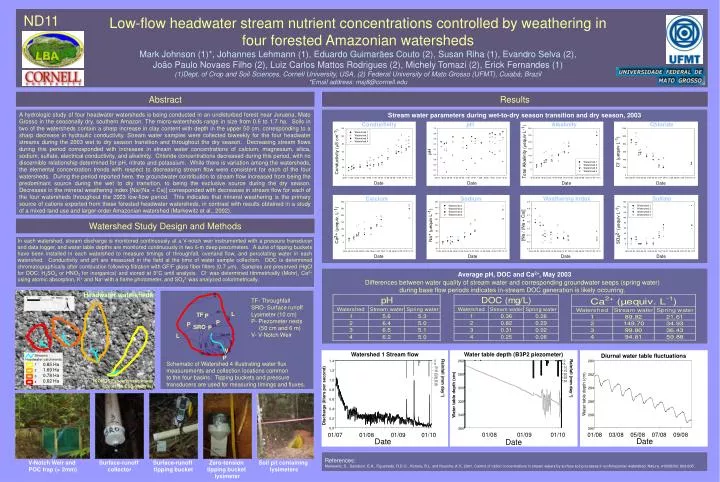
Stream water parameters during wet-to-dry season transition and dry season, 2003. Conductivity. pH. Alkalinity. Chloride. Calcium. Sodium. Weathering Index. Sulfate. Average pH, DOC and Ca 2+ , May 2003.

E N D
Stream water parameters during wet-to-dry season transition and dry season, 2003 Conductivity pH Alkalinity Chloride Calcium Sodium Weathering Index Sulfate Average pH, DOC and Ca2+, May 2003 Differences between water quality of stream water and corresponding groundwater seeps (spring water) during base flow periods indicates in-stream DOC generation is likely occurring. Water table depth (B3P2 piezometer) Watershed 1 Stream flow Diurnal water table fluctuations 260 0 1.4 0 280 5 5 10 10 1.2 15 15 280 20 20 282 25 Rainfall (mm day-1) 25 Rainfall (mm day-1) 1.0 30 30 35 300 284 0.8 Water table depth (cm) Water table depth (cm) Discharge (liters per second) 0.6 320 286 0.4 340 288 0.2 0.0 360 290 01/08 01/09 01/10 01/07 01/08 01/09 01/10 01/08 03/08 05/08 07/08 09/08 Date Date Date V-Notch Weir and POC trap (> 2mm) Surface-runoff tipping bucket Surface-runoff collector • Low-flow headwater stream nutrient concentrations controlled by weathering in • four forested Amazonian watersheds • Mark Johnson (1)*, Johannes Lehmann (1), Eduardo Guimarães Couto (2), Susan Riha (1), Evandro Selva (2), • João Paulo Novaes Filho (2), Luiz Carlos Mattos Rodrigues (2), Michely Tomazi (2), Erick Fernandes (1) • Dept. of Crop and Soil Sciences, Cornell University, USA, (2) Federal University of Mato Grosso (UFMT), Cuiabá, Brazil • *Email address: msj8@cornell.edu ND11 Abstract Results A hydrologic study of four headwater watersheds is being conducted in an undisturbed forest near Juruena, Mato Grosso in the seasonally dry, southern Amazon. The micro-watersheds range in size from 0.6 to 1.7 ha. Soils in two of the watersheds contain a sharp increase in clay content with depth in the upper 50 cm, corresponding to a sharp decrease in hydraulic conductivity.Stream water samples were collected biweekly for the four headwater streams during the 2003 wet to dry season transition and throughout the dry season. Decreasing stream flows during this period corresponded with increases in stream water concentrations of calcium, magnesium, silica, sodium, sulfate, electrical conductivity, and alkalinity. Chloride concentrations decreased during this period, with no discernible relationship determined for pH, nitrate and potassium. While there is variation among the watersheds, the elemental concentration trends with respect to decreasing stream flow were consistent for each of the four watersheds. During the period reported here, the groundwater contribution to stream flow increased from being the predominant source during the wet to dry transition, to being the exclusive source during the dry season. Decreases in the mineral weathering index [Na/(Na + Ca)] corresponded with decreases in stream flow for each of the four watersheds throughout the 2003 low-flow period. This indicates that mineral weathering is the primary source of cations exported from these forested headwater watersheds, in contrast with results obtained in a study of a mixed-land use and larger-order Amazonian watershed (Markewitz et al., 2002). Watershed Study Design and Methods In each watershed, stream discharge is monitored continuously at a V-notch weir instrumented with a pressure transducer and data logger, and water table depths are monitored continuously in two 6-m deep piezometers. A suite of tipping buckets have been installed in each watershed to measure timings of throughfall, overland flow, and percolating water in each watershed. Conductivity and pH are measured in the field at the time of water sample collection. DOC is determined chromatographically after combustion following filtration with GF/F glass fiber filters (0.7 mm). Samples are preserved (HgCl for DOC; H2SO4 or HNO3 for inorganics) and stored at 3°C until analysis. Cl- was determined titrimetrically (Mohr), Ca2+ using atomic absorption, K+ and Na+ with a flame photometer, and SO42- was analyzed colorimetrically. Headwater watersheds TF- Throughfall SRO- Surface runoff Lysimeter (10 cm) P- Piezometer nests (50 cm and 6 m) V- V-Notch Weir L TF P P P SRO P L V P Schematic of Watershed 4 illustrating water flux measurements and collection locations common to the four basins. Tipping buckets and pressure transducers are used for measuring timings and fluxes. 0.85 Ha 1.69 Ha 0.78 Ha 0.62 Ha IKONOS Panchromatic Image (Courtesy EOS-Webster) References: Markewitz, D., Davidson, E.A., Figueiredo, R.D.O., Victoria, R.L. and Krusche, A.V., 2001. Control of cation concentrations in stream waters by surface soil processes in an Amazonian watershed. Nature, 410(6830): 802-805. Zero-tension tipping bucket lysimeter Soil pit containing lysimeters