Download
1 / 1
10 likes | 177 Views
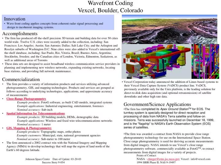
Innovation Wave front coding applies concepts from coherent radar signal processing and design to incoherent imaging systems. Wavefront Coding Vexcel, Boulder, Colorado. Accomplishments The firm has produced off-the-shelf precision 3D terrain and building data for over 50 cities

E N D
Innovation • Wave front coding applies concepts from coherent radar signal processing and • design to incoherent imaging systems. Wavefront Coding Vexcel, Boulder, Colorado • Accomplishments • The firm has produced off-the-shelf precision 3D terrain and building data for over 50 cities • world-wide. Twelve U.S. cities were recently added to the collection, including: San • Francisco; Los Angeles; Austin; San Antonio; Dallas; Salt Lake City; and the Arlington and • Rosslyn suburbs of Washington D.C. Nine cities were also added to Vexcel's international off- • the-shelf database, including: Sao Paulo, Rio, Vitoria, Brazil; Buenos Aires, Argentina; • Stockholm, Sweden; and the Canadian cities of London, Victoria, Edmonton, Saskatoon, as • well as additional areas of Toronto. • These data sets are designed to assist broadband wireless communication service providers in • planning and implementing new wireless networks, expanding existing networks, locating • base stations, and providing full network maintenance. • Commercialization • The firm provides a variety of information products and services utilizing advanced photogrammetry, GIS, and mapping technologies. Products and services are grouped as follows according to underlying technologies, applications, and approximate accuracy of measurements: • Close-Range Photogrammetry • Example products: FotoG software, as-built CAD models, integrated systems Example applications: Industrial engineering, entertainment, forensicsNominal accuracy: Sub-inch • Spatial Information for Telecommunications • Example products: 3D building models, DEMs, demographic dataExample applications: Wireless and fixed wire telecommunications networksNominal accuracy: 1 meter • GIS, Mapping & Photogrammetry • Example products: Topographic maps, ortho photos • Example customers: Municipal, state, national government agencies • Nominal accuracy: Sub-meter to 100 meter • The firm announced a 2002 contract win with the National Imagery and Mapping Agency (NIMA) to develop technology that will map the region of land north of the Earth’s 60 degrees latitude. • Vexcel Corporation today announced the addition of Linux-based systems to • their Vexcel Data Capture System (VxDCS) product line. VxDCS, • previously available only for the Unix platform, is the leading solution for • direct-to-disk data acquisition (and optional retransmission) of satellite • downlinks and other high rate data. • Government/Science Applications • The firm has completed its Apex Ground StationTM for EOS. The turnkey system is specially designed for direct reception and processing of data from NASA's Terra satellite and follow-on missions. Terra was successfully launched on December 18, 1999, and is the "flagship" to NASA's Earth Observation System (EOS) series of satellites. • The firm was awarded a contract from NASA to provide close range photogrammetry technology for use on the International Space Station. Close range photogrammetry is used for deriving accurate measurements from digital imagery. NASA intends to use Vexcel’s close range photogrammetry software, commercially available as FotoGTM, to extract measurements from digital images for a variety of projects. Points of Contact: NASA : chieger@ems.jsc.nasa.govVexcel : info@vexcel.com 1994 SBIR Phase II; NAS 9-19497 Johnson Space Center Date of Update: 03-20-03 Success Story 9-054