Download
1 / 10
100 likes | 347 Views
Chapter 2 The Ancient Near East: Peoples and Empires. On the Fringes of Civilization Impact of Indo-Europeans North of the Black Sea or southwestern Asia Migrations about 2000 B.C. Hittites Asia Minor and Anatolia Suppiluliumas, c. 1380-1340 B.C. Palestine in the First Millennium B.C.

E N D
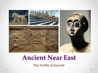
Chapter 2 The Ancient Near East: Peoples and Empires
On the Fringes of Civilization • Impact of Indo-Europeans • North of the Black Sea or southwestern Asia • Migrations about 2000 B.C. • Hittites • Asia Minor and Anatolia • Suppiluliumas, c. 1380-1340 B.C.
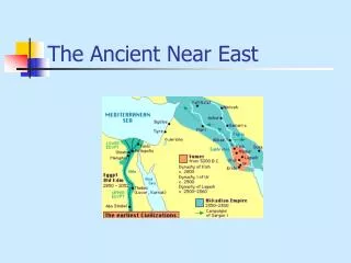
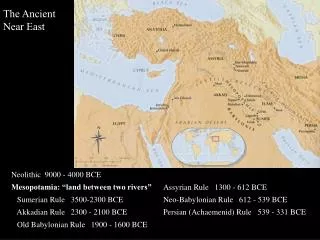
Palestine in the First Millennium B.C. 1. Phoenicia was centrally located on the main trade routes between Egypt, Asia Minor, and Mesopotamia. The first Phoenicians (Canaanites) established their urban centers at Sidon, Byblos, and Ugarit about 3000 B.C. 2. From the Hittites, the Phoenicans learned how to smelt iron and passed the techniques west to the Greeks and south to the African continent. The Phoenician urban civilization also served as a center for manufacturing, the skills of which were learned from the conquering Egyptians who in return were influenced by Phoenician cults and religious ideas. 3. Phoenician culture was influenced by Babylonian mythological stories of the beginning of the world, the birth of the gods, and the creation of humanity. It may have been through the Phoenicians that the Babylonian origin myths were passed to the Hebrews and Greeks. 3. The northern Phoenician coast is isolated by the Lebanon Range but approachable from the sea by a series of harbors at Tyre, Sidon, and Byblos. By about 2000 B.C. Byblos was supplying Egypt with timber from nearby forests. It also traded Egyptian papyrus which the Greeks called byblos after the city from which it came (biblia came to mean book in Greek). The port went into decline after 1100 B.C. as Tyre and Sidon became more powerful. Before 1100 B.C., Tyre was controlled by Egypt and traded with the people of Asia Minor and the Aegean. 4. Palestine is about 150 miles long and less than 10,000 square miles in area. The coast is harborless and except for the rich Plain of Esdraelon the land is barren limestone. Although the area had neither sufficient rainfall, means of irrigation, or economic resources, its location on the chief trade routes from east to west was an invitation to migrating people from the deserts and the mountains. As Palestine became a battleground for stronger nations, the culture of the region came to reflect the influence of Babylon, Egypt, and the Hittites. 5. The name Hebrew may come from the ancient Semitic word abar meaning "to cross or pass over" and perhaps refers to the passage of Abraham and his followers into Canaan across the Syrian Desert fromUr. 6. The Semitic Israelites began their exodus from slavery in the Nile Delta about 1230 B.C. Crossing a series of shallow lakes, they drove south down to the barren, rock-strewn Sinai, the Wilderness of Zin. At Mt. Sinai their God gave Moses the Ten Commandments. About 1200 B.C. the Israelites crossed the Jordan River into Canaan where they came into conflict with the Philistines who were part of the Sea Peoples who had settled the coastal plain of Palestine. The wars forced the scattered Israelite tribes to unite under a king. Once the Philistines were defeated, Israelites split into two halves: in the north, Israel with its capital at Samaria, and in the south, Judah centered in Jerusalem. 7. The Assyrians (see Acetate 6, Map 2.2) overran Israel, destroying the capital of Samaria in 722 B.C. Many Hebrews were dispersed to parts of the Assyrian Empire where they merged with neighboring people, gradually losing their identity. Questions: 1. What role did the Phoenicians play in cultural diffusion? 2. How did the environment and contact with other people shape the Israelites Palestine in the First Millenium B.C.
The Hebrews: “The Children of Israel” • The United Kingdom • Saul, c. 1020-1000 B.C. • David, c. 1000-970 B.C. • Solomon, c. 970-930 B.C. • Temple of Jeerusalem • Ark of the Covenant • The Divided Kingdom • Kingdom of Israel • Samaria • Kingdom of Judah • Jerusalem • Assyria
The Spiritual Dimensions of Israel • Yahweh • Hebrew Bible • Torah, first five books • Covenant, Law and Prophets • Covenant with Yahweh • Obedience to the law of God • Prophets • Social Structure of the Hebrews • “Men of rank and influence” • “People of the land” • Commerce by foreigners • Slaves
Family • marriage • women • divorce • children • Neighbors of the Israelites • Philistines • Phoenicia • Traders • Colonies • Alphabet
The Assyrian and Neo-Babylonian Empires 1. The Armenian highlands and the plains of Babylon bound the lands of ancient Assyria on the north and south. In the east, the Zagros Mountains lying justbeyond the Tigris River hemmed inAssyria. These geographical roadblocks kept the Assyrians from ever permanently expanding north and east. To the west, however, the absence of natural boundaries and strong powers after the demise of the Hittite Empire permitted Assyrian expansion to the Mediterranean. 2. Mesopotamia and the surrounding lands were satisfactorily endowed but those of Assyria were not. Although iron deposits were present, the Assyrians had to seek other mineral resources from Armenia, Persia, central Asia Minor, the Danube region, and Egypt. Nevertheless, the Assyrians generally remained inland focusing on military affairs and agriculture. With regular rainfall, Assyria was a land of farming villages with few significant cities. Foreigners generally carried on trade. 3. The Assyrians were a Semitic-speaking people who were vassals of foreign rulers. They were dominated by the Hurrian kingdom of Mitanni from 1650-1360 B.C. When the Hittites destroyed the kingdom of Mitanni, the Assyrians became independent after 1360 B.C. Complete re-assertion of Assyrian power was achieved under Tiglath-pileser I (c. 1115-1077 B.C.) 4. The aggressive nature of the Assyrians may have been due to threats from neighbors, experiencing attacks from the war-like tribes to the north and east and the Babylonians to the south. These threats prompted political cohesion and militarism. By 700 B.C. the Assyrian Empire controlled Mesopotamia, Elam, parts of the Iranian plateau, parts of Asia Minor, Syria, Palestine, and Egypt down to Thebes. The Assyrian army used a variety of tactics including guerrilla and siege warfare as well as terror, especially laying waste the land of enemies by destroying dams, burning crops, cutting down trees, obliterating towns, and committing atrocities against the people. Such policy was generally reserved for those who were already part of the empire and then rebelled. Prisoners of newly conquered territories were often deported from their lands to Assyria where the objective was to repopulate areas decimated by warfare. Over the course of three centuries some four to five million people were deported to Assyria resulting in a very racially and linguistically mixed people. 5. The Chaldeans rose in Babylonia after successfully allying with the Medes from Iran to sack the Assyrian capital Nineveh. Later, the Chaldeans defeated Egypt to control Syria and Palestine and would eventually sack Jerusalem, carrying off the Jews to Babylon. 6. Babylonia became wealthy due to its location on the trade routes crossing Mesopotamia, a strong agriculture, and a developed textile and metals industry. An eight-mile wall, encircled by a moat filled from the Euphrates surrounded the capital of Babylon. The city was adorned with temples and palaces including the Hanging Garden, which consisted of terraces and an artificial mountain upon which was a lush garden irrigated by water piped to the top. In 689 B.C. the city was sacked by the Assyrians. Questions: 1. How did the geography of the Near East have an impact on the character and nature of the Assyrians and Chaldeans? 2. Why did the subject peoples resent Assyrian rule? The Assyrian and Neo-Babylonian Empires
The Assyrian Empire • Tiglith-pileser I (c. 1115-1077 B.C.) • Tiglith-pileser III (744-727 B.C.) • Ashurbanipal (669-626 B.C.E.) • Military machine • Army • pioneer corps • guerrilla warfare • siege • terror tactics • Iron weapons • Horse-drawn war chariots • Society and culture
The Persian Empire at the Time of Darius 1. The original homeland of the Persians was Persis in the southwestern corner of modern Iran. It is a land of stark contrasts. The western coast along the Persian Gulf is narrow and harborless. Hemming in this hot arid region to the east are abrupt mountains rising to six thousand feet. Beyond the mountains is a high plateau broken by valleys, which are fertile and blessed with adequate rainfall. Here in a temperate climate a considerable population could be supported. Nevertheless, this was not the basis for an empire since there was no outlet to the sea and the only routes west were through the mountain roads to Susa and Babylon. 2. The harshness of Persis is characteristic of all of Persia. High mountains that isolate the interior from the sea surround a vast central plateau, which extends from the Tigris-Euphrates valley in the west to the Indus valley in the east. On this broad plain lay scattered oases and two immense salt deserts (Dasht-i-Lut and Dasht-i-Kavir covering some 38,000 square miles) which physically form a barrier between the east and west. 3. The Dasht-i-Kavir southeast of the Caspian Sea is mostly covered with salt instead of sand and is devoid of water or plant life. Facing the impossible desert, nomads migrating into Persia from central Asia and the steppes of Russia would either turn eastward to India or westward to Mesopotamia. 4. The Royal Road stretched from Sardis in western Lydia to the chief capital of Susa. A distance of 1600 miles, there were stations placed about every fourteen miles so that messengers could get fresh horses. The journey could be made in a week. In addition, there were a number of trunk roads linking such places as Memphis, which tied into the highway. Later, the Royal Road was extended another three hundred and fifty miles to the new capital of Persepolis built by Darius. The road was also used for commerce and contributed to the continuation of the flow of goods between east and west. 5. Darius (521-486 B.C.), after a year of civil war, began strengthening the empire. He built a canal linking the Red Sea and the Mediterranean by way of the Nile, campaigned into western India extending Persian territory to the Indus River, and conquered Thrace making the Macedonian king a vassal. In 499 B.C. the Ionian Greek city states revolted against the Persians and after receiving aid from the mainland Greeks invaded Lydia and burned the provincial capital of Sardis (see Acetate 10, Map 3.3). The rebels were ultimately punished and Darius invaded the Greek mainland culminating in his defeat at the Battle of Marathon in 490 B.C. Questions: 1. How did the geography of Persia affect not just the Persians but also other people? 2. How did Darius bring the Persian Empire to its zenith? The Persian Empire at the Time of Darius
Neo-Babylonian Empire • Nebuchadnezzar III (605-562 B.C.) • The Persian Empire • Cyrus the Great (559-530 B.C.) • Cambyses (530-522 B.C.) • Darius (521-486 B.C.) • Government • Satrapies (provinces) • Royal road – Sardis to Susa • Persian king • Army • Immortals (cavalry) • Infantry • Zoroastrianism