Download
1 / 8
80 likes | 200 Views
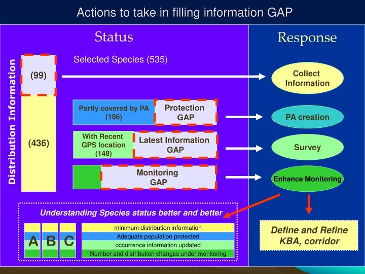
Selected Species (535). (99). Collect Information. Partly covered by PA (196). Protection GAP. ( 436 ). PA creation. Distribution Information. With Recent GPS location (148). Latest Information GAP. Survey. Monitoring GAP. Enhance Monitoring.

E N D
Selected Species (535) (99) Collect Information Partly covered by PA (196) Protection GAP (436) PA creation Distribution Information With Recent GPS location (148) Latest Information GAP Survey Monitoring GAP Enhance Monitoring Understanding Species status better and better Define and Refine KBA, corridor minimum distribution information B C Adequate population protected A occurrence information updated Number and distribution changes under monitoring Actions to take in filling information GAP Status Response
The most basic habitat model Possible distribution County Distribution and = Habitat and Elevation 160 species has those basic information, and more to come.
Sp. 002 Sp. 003 Sp. 001 Add all 160 together, to get some understanding on Potential Biodiversity Rich area. + + + … … = + Sp. 160
Southeast Tibet Biodiversity Survey 2007 2005.8 RAP
200-500 locality Points • Evenly distributed Obtain more accurate distribution from survey Predict distribution of target species
Demonstrating Monitoring in Nature Reserves and communities, Armed with GIS and Database
Working on… • The Building of the landscape monitoring system, supported by communities and nature reserve staffs. Forest Change detected, Landscape Changes under Monitoring • More field verification work to increase the product’s accuracy; • More field survey to find out deep reasons caused forest changes; • Extend this approach to large area, Maybe whole China in future; • Extend this approach to more time period: 1980s -1990s, 2000 -2005.