Download
1 / 11
110 likes | 199 Views
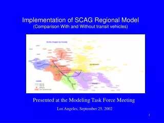
San Francisco Estuary Institute. Item #3a. Develop/update spreadsheet model for regional loading and trends. Michelle Lent, John Oram, and Lester McKee Sources Pathways and Loadings Workgroup May 6 th 2010. San Francisco Estuary Institute. Item #3a. Background: Version 1.

E N D
San Francisco Estuary Institute Item #3a Develop/update spreadsheet model for regional loading and trends Michelle Lent, John Oram, and Lester McKee Sources Pathways and Loadings Workgroup May 6th 2010
San Francisco Estuary Institute Item #3a Background: Version 1 • Developed by Davis et al. in 2000 to estimate contaminant loads to Bay and coastal waters • Simple rainfall/runoff model • Loads generation: W = Cj rj i Aj j where j = land use categories • Loads estimated for: • TSS • Cadmium • Chromium • Copper • Lead • Nickel • Zinc • BOD
San Francisco Estuary Institute Item #3a Background: Version 1 • Spatial extent • CalWater HUC8 • Spatial resolution • 34 watersheds • Temporal resolution • Long-term average annual scale
San Francisco Estuary Institute Item #3a Updates/Refinements • Replace 1995 ABAG Land Use data set with ABAG 2005 (unless WG recommends differently) • Increase spatial resolution (finer-scale watersheds) using WLA boundaries and BASMAA nomenclature • Increase land use category resolution (e.g. split out transportation land use – pending outcomes of STLS task 4d) • Use spatially averaged rainfall instead of watershed centroid method • Increase temporal resolution to long-term monthly scale • Calibrate runoff coefficients
San Francisco Estuary Institute Item #3a Spatial Extent Vs. Vs. Or some other extent…
San Francisco Estuary Institute Item #3a Increase temporal resolution • 30-year average monthly PRISM data • 800-meter grid • 100ths of mm rainfall • Potentially could scale/calibrate runoff coefficients by month to account for antecedent conditions, e.g. using Z4LA data
San Francisco Estuary Institute Item #3a Impacts of increasing spatial and temporal resolution: ~3*10 Watersheds ~5*102 Watersheds Vs. If 10 POC loads calculated per watershed, Annual output: ~3*102 Monthly output: ~3*103 If 10 POC loads calculated per watershed, Annual output: ~5*103 Monthly output:~5*104 …so will need to aggregate watershed output for reporting
San Francisco Estuary Institute Item #3a Landuse-based Runoff Coefficients…some options: • Previous version of model (BASMAA, 1996; SCCWRP, 2000) - Developed specifically for Bay Area (mostly) • Rantz, 1971 - Developed specifically for Bay Area • Browne, 1996 - Also split out by slope and soil group • Compilation in Park et al., 2009
San Francisco Estuary Institute Item #3a Potential pollutants to model (as land-use-specific data are available) • MRP Category 1: • Suspended Sediments • Total Organic Carbon • Copper • Mercury • PCBs • Nitrate as N? • MRP Category 2: • Selenium • Phosphorous • PBDEs • PAHs • Pyrethroids • OC Pesticides • Chlordane • DDTs • Dieldrin Need to prioritize effort: Base model development versus Number of pollutants added
San Francisco Estuary Institute Item #3a Reached consensus? • Spatial extent of model • Desired aggregation of output • Recommended runoff coefficients to try • How to divide time/effort between base model development (e.g. calibration) and further model development (e.g. adding in more POCs) • Which POCs to include in this phase and which to include in subsequent phases • Any other issues?
San Francisco Estuary Institute Item #3a RMP 2011 rationale for further support • This model supports STLS/MRP management questions by: • Providing regional loads estimates • Testing BMP options • In 2010 the model will: • Provide average monthly regional estimates of storm water volume, suspended sediment loads, and other POC loads (as specified by WG) • In 2011, with further funding, the model could potentially: • Provide average monthly regional loads estimates of more POCs • Be further calibrated to runoff, if needed/desired • Be updated with local land-use specific EMCs, if available • Have BMP testing capabilities developed