Download
1 / 18
180 likes | 301 Views
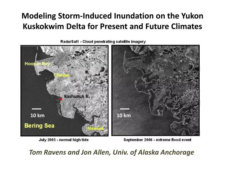
Modeling Storm-Induced Inundation on the Yukon Kuskokwim Delta for Present and Future Climates. Tom Ravens and Jon Allen, Univ. of Alaska Anchorage. Kashunuk R. 10 km. 10 km. Research Goal: determine the likely change in YK Delta ecology due to storm surges – enhanced by sea level rise.

E N D
Modeling Storm-Induced Inundation on the Yukon Kuskokwim Delta for Present and Future Climates Tom Ravens and Jon Allen, Univ. of Alaska Anchorage Kashunuk R. 10 km 10 km
Research Goal: determine the likely change in YK Delta ecology due to storm surges – enhanced by sea level rise • Tasks: • Develop and validate a storm surge model • Identify a number of representative storms from the past 40 years • Model these storms and their inundation under present climate conditions • Re-model these storms assuming one or more sea level rise scenarios • Compute an inundation index from each model run • Compute an annual inundation index based on inundation indices from selected storms • Establish the relationship between annual index and ecological parameters (e.g., vegetation type) under present climate • Infer changes in ecological parameters (e.g., vegetation type) under a future climate based on projected changes in inundation index
Storm surge modeling –fine scale model of YK Delta Kashunuk River Hooper Bay
Storms to study 1Chapman et al. Storm-Induced Water Level Prediction Study for the Western Coast of Alaska, USACE. Reported surge is for Hooper Bay. It does not include tides. 2 Calculated using ADCIRC (course grid) and DELFT3D (fine grid) models. Reported surge is for lower Kashunuk River. It does not include tides.
15 year, 4 m 1 year, 2.5 m 5 year, 3.2 m
GMT AK time
1 year storm inundation index wide view close-up [m-days] [m-days]
5 year storm inundation index wide view close-up [m-days] [m-days]
15 year storm inundation index wide view close-up [m-days] [m-days]
Annual Inundation Index for current climate based on a weighted average of indices from the 1, 5, and 15 year storm (using weights of 1, 1/5, 1/15 - approximately) Nearshore Inundation Index dominated by contribution of 1-year storm Inland Inundation Index dominated by contributions of 5 and 15-year storms [m-days/yr]
Correspondence between 1-2 m-day/yr annual Inundation Index and presence of Brackish Wet Sedge Meadow in current climate Brackish wet sedge meadow 1-2 m-days/yr [m-days/yr]
Annual Inundation Index – current climate Annual Inundation Index – future climate 1-2 m-days/yr 1-2 m-days/yr [m-days/yr] [m-days/yr] 7 km translation of 1-2 m-days/yr annual Inundation Index region – suggesting a similar shift in the location of the Brackish Wet Sedge Meadow vegetation type
Conclusions • Preliminary model validation efforts indicate that the model works reasonably well for 1-yr storm. • The annual inundation index was well-correlated with vegetation type. • The annual inundation index increased significantly with the assumed 0.4 m sea level rise. • Significant shifts in vegetation are expected with a 0.4 m sea level rise.
Future Work • Include wind and wave action in storm surge model. • Do additional model validation including use of aerial images of inundation extent to calibrate overland flow roughness. • Study additional storms and calculate return period of those storms at the Kashunuk River mouth. • Analyze the relationship between annual inundation index and vegetation type more precisely. • Examine the relationship between inundation index and bird/nest abundance. • Model and analyze pond water quality. • Model and analyze geomorphic change.
Collaborators and supporters • Craig Ely, John Terenzi (USGS, Alaska) • Torre Jorgenson (Ecoscience) • Raymond Chapman, Ken Eisses (USACE) • Steven Gray (USGS AK Climate Science Center) • Joel Reynolds, Karen Murphy (Western Alaska Landscape Conservation Cooperative) • Sarah Saalfeld (USFWS)