Download
1 / 19
190 likes | 302 Views
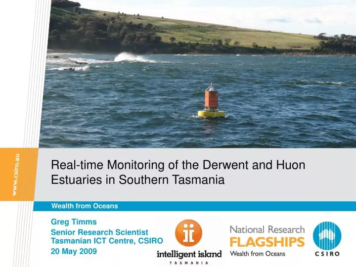
Real-time Monitoring of the Derwent and Huon Estuaries in Southern Tasmania. Wealth from Oceans. Greg Timms Senior Research Scientist Tasmanian ICT Centre, CSIRO 20 May 2009. The Tasmanian Marine Analysis Network (TasMAN).

E N D
Real-time Monitoring of the Derwent and Huon Estuaries in Southern Tasmania Wealth from Oceans Greg Timms Senior Research ScientistTasmanian ICT Centre, CSIRO 20 May 2009
The Tasmanian Marine Analysis Network (TasMAN) Collecting and integrating real-time data to support multiple uses of the Derwent/Huon/Channel Region in southern Tasmania • The role of the Tasmanian ICT Centre • Present existing data in a standard format/interface • Set up infrastructure/communications to enable real-time data collection from the region • New data collection technologies • Data management and streaming data processing (e.g. event detection) • Integration of data with CSIRO models for forecasting • Data visualisation • Current partners/data providers/stakeholders • HydroTas • Bureau of Meteorology • IMOS • CSIRO Marine and Atmospheric Research
The role of sensor networks • Provide the ability to collect real-time and near real-time data • Automated collection • Enables quick response to events • Monitor recovery • Limits costs and liabilities • Enables reliable short-term forecasts (when coupled with models)
Huon Surface node Underwater node TasMAN • Sensor locations • CSIRO Wharf • Derwent mouth • Mid-Derwent • North-West Bay • Huon • Storm Bay • Temp & Salinity initially • Turbidity/ Dissolved O2 / Fluorescence later Derwent Derwent D’EntrecasteauxChannel D’EntrecasteauxChannel Huon Deployed node Planned node
Sensor Cluster – Mouth of the Derwent high gain (7 dBi)antenna acoustic modem with batteries and Fleck SeaBirdSBE-37 sensor mooring chain pycnocline inductive cable withattached sensors mooring acousticrelease
Fixed automated sensors • Time series data, single location • Real-time comms (Radio, Acoustic, Satellite, 3G phone) or loggers
Fixed automated sensors - challenges • Security (particularly in coastal and estuarine environments) • Physical damage (waves, wind, etc) • Permissions • Cost – $3k up to $150k+ • Deployment/maintenance • Biofouling
CSIRO Autonomous Underwater Vehicle • • Now at third generation • • Starbug research focus • • Vision-based navigation & control • • Autonomy • • Cooperative robotics • • Human robot interface • • 3D visualisation • • Robot sensor network interaction • • Starbug specifications • • Mass: 26kg • • Length: 1.2 m • • Propulsion: 5 thrusters • • Endurance: 12 hrs @ 0.6m/s • • Sensors: 4 cameras, pressure, GPS
Identifying events in the river Snow melt? – a cold water plume in the Derwent (Aug 2008)
Model-Sensor Integration (current situation) MESOLAPS Model(Global Atmospheric Model) Bluelink Model(Global Ocean Forecasting)10km grid Derwent River Flowand temperature(Hydro Tas)hourly data Hobart wind speed and direction(BoM)hourly data SE Tasmania Model (CMAR) (Ocean/Estuary Forecasting)polar grid – 400m to 2km Huon River Flow(BoM)hourly data Comparison Nowcast and up to 24 hour forecast of salinity and temperature in estuaries and coastal waters of SE Tasmania TasMAN (Tas ICT Centre)15 min temperature and salinity data at six locations
Model-Sensor Integration (plan) Bluelink Model(Global Ocean Forecasting)10km grid MESOLAPS Model(Global Atmospheric Model) Derwent River flowand temperature(Hydro Tas)hourly data Hobart wind speed and direction(BoM)hourly data SE Tasmania Model (CMAR) (Ocean/Estuary Forecasting)polar grid – 400m to 2km Huon River flow(BoM)hourly data Maria Island NRS (IMOS)hourly data Sensor tasking Nowcast and up to 24 hour forecast of salinity and temperature in estuaries and coastal waters of SE Tasmania Identification ofnew sites suitable for marine industry TasMAN (Tas ICT Centre)15 min temperature, chlorophyll, dissolved oxygen and salinity data at 15-17 locations Identification of systemic changes in river conditions Early warning and predicted movement of algal blooms
TasMAN - Data Visualisation Sensor Observation Service (April 2009)
TasMAN - Data Visualisation Web interface (November 2008)
Tasmanian ICT Centre Dr Greg Timms Senior Research Scientist Phone: +61 3 6232 5572 Email: greg.timms@csiro.au Web: www.csiro.au/science/TasMAN Thank you Contact UsPhone: 1300 363 400 or +61 3 9545 2176Email: Enquiries@csiro.au Web: www.csiro.au