Download
1 / 20
200 likes | 374 Views
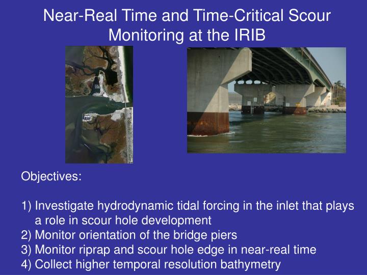
Near-Real Time and Time-Critical Scour Monitoring at the IRIB. Objectives: Investigate hydrodynamic tidal forcing in the inlet that plays a role in scour hole development Monitor orientation of the bridge piers Monitor riprap and scour hole edge in near-real time

E N D
Near-Real Time and Time-Critical Scour Monitoring at the IRIB • Objectives: • Investigate hydrodynamic tidal forcing in the inlet that plays a role in scour hole development • Monitor orientation of the bridge piers • Monitor riprap and scour hole edge in near-real time • Collect higher temporal resolution bathymetry
IRIB SCOUR PROBLEM 1994 1996 1999 2004 Images courtesy of Jeff Gebert, USACE Over the last 12 years, scour hole depths and spatial extent have increased dramatically Will scour holes begin to undermine protective riprap and interfere with pier stability?
IRIB PIER ORIENTATION MONITORING Use a dual axis tilt sensor to monitor long-term pier orientation Most appropriate pier due to potential for scour hole interference
IRIB PIER ORIENTATION MONITORING Cabling • One 8-conductor cable spans two piers • This cable transmits data and powers sensor • Limits electrical access needs to land
IRIB PIER ORIENTATION MONITORING Powering and data collection Dataq DI-710 stand alone logger Omega Power Converter (sends power to sensor) • Box secured to top of land-based concrete pier • Logger and router plug into box power unit • Sensor receives power from converter • Will need power access from land only! D-Link Pocket Router Router connects to ethernet port on logger so data can be downloaded without opening box Power unit Waterproof Enclosure
IRIB TIDAL CURRENT MONITORING Use boat mounted acoustic Doppler Current Profiler to collect data over a tidal cycle.
DETAILED MONITORING EFFORTS PENDING FUNDING Do we want to include physical model study? Might be difficult for a student to complete in allotted time? However, would be a nice complement to study
WHY CONDUCT A THOROUGH INVESTIGATION? Can answer questions such as: 1) What is the spatial and temporal variability of the scour hole? 2) What is the spatial and temporal variability of the riprap protecting the pier? 3) How are variations in riprap armament and scour hole morphology related to tidal forcing conditions? 4) How does the scour hole respond to storm events? 5) Is the rate of scour hole development increasing or decreasing? To answer these important questions, it is necessary to collect the response AND the forcing conditions simultaneously.
3D PROFILING SONAR 3D XYZ elevation data Advantage: System does not need to be engineered in-house. Can be cabled to logger for near-real time internet access.
3D PROFILING SONAR Bridge mounting: Top view Pier Pier East pier of North pier pair Scanned area below sensor sensor Routinely image (X,Y,Z coordinates) the area directly below and adjacent to the pier ~120 ft
pier Pier On land 3D PROFILING SONAR LAYOUT Network connected PC at Coast Guard Station Wireless connection Comms cable attached to bridge deck PC, logger Power Edge of inlet Electronics Package sensor
TIDAL CURRENT MEASUREMENT Tidal currents must play a role in scour hole evolution and migration Use Acoustic Doppler Current Profiler (ADCP) to obtain the time dependent tidal flow. Communications layout is the same as the sonar
TIDAL CURRENT PROFILING Show some example image of tidal or wave ADCP data if we can get it. Pretty lame schematic and probably not needed pier pier Edge of inlet Edge of inlet Measure current velocity
SCOUR HOLE AND RIPRAP BATHYMETRIC MAPPING Army Corps, 2004 • Army corps data collected roughly every 2-3 years • Shows that the scour holes have deepened and migrated, particularly seaward holes • No indication as to the high frequency evolution of holes (tidal, storm, seasonal) • Requires more frequent and targeted monitoring
BATHYMETRIC MAPPING USING A WAVERUNNER Will survey roughly monthly, but also some targeted surveying pre- and post-storm and surrounding a tidal cycle
BATHYMETRIC MAPPING USING A WAVERUNNER • Example wave runner bathymetric data from the surf zone. • Lack of waves in the inlet may simplify data collection • Will be able to quantify scour hole variability
COSTS Continued This is HUGE, but necessary to get work done. They may decide they are only interested in certain aspects or not at all
BUDGET DESCRIPTION • Large initial investment in the first year to acquire instrumentation • Expenses in year 2 are significantly reduced and cover the salary for PI’s and the student to continue the monitoring effort and data analysis. • In situ equipment has a lifespan of at least 5 years and can be extended if cleaned and serviced regularly • Waverunner lifespan is roughly 10 years with adequate upkeep • Lifespan of instruments means they can be in service until the new IRIB is completed. Monitoring can continue after old bridge is removed • Monitoring can be modified to occur at other locations of interest to DelDot (e.g. C&D Canal Bridge) as necessary.