Download
1 / 51
540 likes | 886 Views
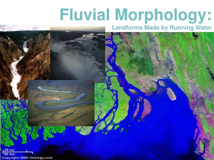
Fluvial Morphology: Landforms Made by Running Water. What is the most important geomorphic agent shaping the landscape? RUNNING WATER Rivers and Streams. What is the work of rivers and streams? Erosion Transportation Deposition.

E N D
What is the most important geomorphic agent shaping the landscape? RUNNING WATER Rivers and Streams • What is the work of rivers and streams? • Erosion • Transportation • Deposition Fluvial Morphology:Study of Landforms Made by Running Water FLUVIAL: from the Latin fluvins for ‘running water’ or streamflow
The Long Profile of Streams • At their headwaters, the grade of a stream is usually steep. • At Mid-streams, the angle of the grade becomes more gently sloping. • Near the mouth of the stream, the grade becomes almost flat.
Stream Stages • Streams also show three stages of gradation from the mountains to the sea, with associated erosional and depositional features: • Youth • Maturity • Old Age
Stream Stage 1 - Youth • Characteristics of Youthful Streams • Steep irregular profile • Waterfalls, rapids, and plunge pools • River is deepening its channel • Cutting into bedrock • V-shaped cross-section
The Cycle of Erosion • Youthful stage • headward erosion and • vertical downcutting dominant • steep stream gradients promote valley deepening • narrow, V-shaped valleys
The channel at upstream point A-B • This channel is located in the stream's headwaters. • The stream gradient and surrounding topography is quite steep. • Stream velocity is at a maximum and cuts a narrow deep channel. • The floodplain is minimal as high velocities carry all sizes of load down stream. • Stream load is high as the steep gradient provides the energy for extensive erosion • Producing a V-shaped river valley.
Waterfalls and Rapids • Hard rock layers have not yet been smoothed away • A waterfall is a vertical drop in a streambed • Rapids are stream sections with extremely strong currents. • Both are sites of vigorous erosion • Potential Hydro Electric Power
Stream Stage 2 - Mature Valley • Characteristics of Mature Valley Streams • Valley widening begins • Meandering Stream • Floodplains
Figure c-d: Stream channel near the middle of a typical stream profile.
The channel is now leaving the mountainous terrain and entering a landscape that is more gently sloping. • Causes a sudden reduction in the stream's velocity. • The stream adjusts to this change, by depositing most of its coarsestream load onto the floodplain. • The stream also takes on a braided channel form. • These channels are always changing in size, number, and location
Lateral Erosion - Valley Widening Begins • Erosion is greatest on the outside bend • Cut-banks • Deposition on the inside bend • Meanders • Widen the valley • Form cutoffs • Create oxbow lakes
Stream Stage 3 - Old Age • Characteristics of Old Age Streams • Wide Alluvial Valley Stage • Natural Levees • Depositional feature • Parallel to the stream channel on both banks
The channel near the mouth of the stream (Figure E-F). Extensive flat floodplain is composed of Deposits from channel meandering. The channel is quite large and U-shaped. Stream discharge is at a maximum and sediment load is generally composed of finer materials.
A river cut-off results in a portion of the river isolated from the new channel called an oxbow
Rivers drop their load when they enter the ocean and form a ________?
Deltas Large deposit of alluvialsediment located at the mouth of a stream where it enters a body of standing water. http://www.youtube.com/watch?v=AjZLAw_lgZ4&feature=related
Deltas are created when the sediment load carried by a stream is deposited because of a sudden reduction in stream velocity. Fig. 17-27b, p. 491
. Some deltas, like the Nile, have a triangular shape Fig. 17-27a, p. 491
Lake Itasca is a small glacial lake, approximately 1.8 square miles (4.7 km²) in area, in the Lake District of Northwestern Minnesota. It is the Source[1] of the Mississippi River.
http://www.youtube.com/watch?v=ta35C488dnE http://www.ilike2learn.com/ilike2learn/Rivers/Longest%20Rivers.html
Is this river aggrading or degrading? Is it near the headwaters or the delta?
Is this river aggrading or degrading? Is it near the headwaters or the delta? Aggrading, at the delta
Is this river aggrading or degrading? Is it near the headwaters or the delta?
Is this river aggrading or degrading? Is it near the headwaters or the delta? Graded, near the middle or end of its course. Missouri River, MO
Is this stream aggrading or degrading? Is it near the headwaters or the delta?
Is this stream aggrading or degrading? Is it near the headwaters or the delta? DEGRADING, NEAR THE HEADWATERS Canadian Rockies