Download
1 / 16
170 likes | 431 Views
Fallon, NV Canal Survey Resistivity: MiniREs and VLF. 2009 George Lightwood Scott Craig Danny Lazzareschi. Overview. Location Purpose Methods Results Interpretations Conclusions. Location. Dry canal bank west of Fallon, NV Local mapped units are Badlands soil and Hawsley Sand.

E N D
Fallon, NV Canal SurveyResistivity:MiniREs and VLF 2009 George Lightwood Scott Craig Danny Lazzareschi
Overview • Location • Purpose • Methods • Results • Interpretations • Conclusions
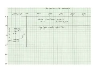
Location • Dry canal bank west of Fallon, NV • Local mapped units are Badlands soil and Hawsley Sand. • Typical resistivities for soils consisting of predominantly of clay minerals containing brackish water: 1 to 100 Ω-m. • Soils consisting of sand and silt typically have a resistivity on the order of several hundred Ohm-meters
Purpose • Use electrical methods to look for locations of seepage and internal erosion of canal walls • Previous studies found these methods effective Asch, T. H., M. Deszcx-Pan, B.L. Burton, and L.B. Ball, 2008, Geophysical Characterization of the American River Levees, Sacramento, California, using Electromagnetics, Capacitively Coupled Resistivity, and DC Resistivity, Open-File Report 2008-1109, U.S. Department of Interior, U.S. Geological Survey, Washington, D.C. Panthulu, T.V., C. Krishnaiah, J.M. Shirke, 2001, Detection of seepage paths in earth dams using self-potential and electrical resistivity methods in Engineering Geology 59, pp 281-295.
Methods:MiniRes • Wenner Array • A-spacings of 1, 1.47, 2.15, • 3.16, 4.64, 6.81 and 10 meters • ρa=2πaΔV/I • Thanks to L and R Instruments
Survey • Soundings 1-9 in canal bank profile • Sounding 10 on playa • Sounding 11 at toe of canal bank • Soundings 12, 13 on ReMi Line • 8 4.64 A-Spacing
Methods: VLF • Very Low Frequency(15-25Hz) • Geonics EM16R • Distant high power sources • Finds EM coupling with conductors in the earth • Anomalies perpendicular to direction toward source • Source in Jim Creek, WA • Measurements made at locations of first 9 MiniRes
Interpretation: Resistivity Sounding • Resix to calculate resistivitites of layers • Resist to graph • Typical sounding at Station 8
Interpretation: Resistivity Sounding • Sounding 10 on Playa • Thinner resistive layer • Sounding 11 at toe of canal bank • Opposite layering
Results:VLF • Apparent resistivity from 8 to 11 Ohm-m • Phase angles from 34 to 38 degrees • Tried to construct a 2-layer model from the data • Resistivity of the top layer was assumed to be on the order of 10 to 30 Ohm-m • not successful at identifying contact • method is poorly suited to defining the boundary between a highly conductive layer overlying a layer of higher resistivity (Podder and Rathor, 1983) • Soil was at upper limit of conductivity senitivity Podder, M. and B.S. Rathor, 1983, VLF Survey of the Weathered Layer in Southern India, Geophysical Prospecting, vol. 31, pp. 524-537.
Conclusions • Canal Bank consists of 3 layers- high resistivity in between two low resistivity lavers • Top layer likely compacted clay • Middle layer likely sands excavated from the canal • Bottom layer likely clays • Middle sand layer a likely conduit for fluid flow • MiniRes much more effective than VLF for detailed site study
Thanks • Questions?