Download
1 / 28
280 likes | 384 Views
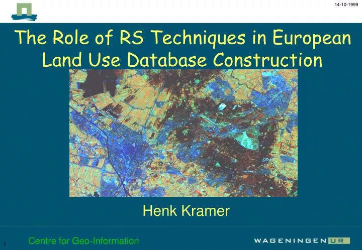
The Role of RS Techniques in European Land Use Database Construction. Henk Kramer. introduction most important satellite sensors available datasets land use database construction conclusions. blue. green. red. near infrared. mid infrared. thermal infrared. introduction.

E N D
The Role of RS Techniques in European Land Use Database Construction Henk Kramer Centre for Geo-Information
introduction • most important satellite sensors • available datasets • land use database construction • conclusions Centre for Geo-Information
blue green red near infrared mid infrared thermal infrared introduction scanning the earth Centre for Geo-Information
color photo false color photo blue, green and red green, red and near-infrared false color red, near-infrared and mid-infrared different ways to look at satellite images Landsat TM: blue, green, red, near-infrared and mid-infrared Centre for Geo-Information
introduction • most important satellite sensors • available datasets • land use database construction • conclusions Centre for Geo-Information
most important satellite sensors : • NOAA AVHRR • IRS-1C WIFS • RESURS-01 MSU-SK • LANDSAT TM • SPOT XS • IKONOS Centre for Geo-Information
NOAA AVHRR spatial resolution : 1.1 km scene size : 2399 km wide pole to pole Centre for Geo-Information
IRS-1C WIFS spatial resolution : 188 m scene size : 810 x 810 km Centre for Geo-Information
RESURS-01 MSU-SK spatial resolution : 160 m scene size : 600 x 600 km Centre for Geo-Information
Landsat TM spatial resolution : 30 m scene size : 183 x 172 km Centre for Geo-Information
SPOT XS spatial resolution : 20 m scene size : 60 x 60 km Centre for Geo-Information
IKONOS spatial resolution : 4 m mss 1 m pan scene size : 11 x 11 km Centre for Geo-Information
introduction • most important satellite sensors • available datasets • land use database construction • conclusions Centre for Geo-Information
available datasets : • CORINE • IGBP • PELCOM • pan-european • created with RS techniques Centre for Geo-Information
CORINE land cover database Coordination of Information on the Environment Centre for Geo-Information
CORINE land cover database methodology : computer-assisted photointerpretation of Earth observation satellite images, with the simultaneous consultation of ancillary data reference date : 1986 - 1997, country dependend update frequency unknown plans for update recently announced Centre for Geo-Information
Detail IGBP global land cover database International Geosphere-Biosphere Programme Centre for Geo-Information
IGBP global land cover database methodology : multitemporal unsupervised classification of NDVI data with post-classification refinement using multi-source earth science data. reference date : April 1992 - March 1993 update frequency unknown Centre for Geo-Information
PELCOM 1km land cover database Pan European Land Cover Monitoring Conif. Forest Decid. Forest Mixed Forest Grassland Rainfed arable land Irrigated arable land Permanent crops Shrubland Barren land Perm. Ice and Snow Wetlands Water Urban Centre for Geo-Information
PELCOM 1km land cover database methodology : stratified multitemporal supervised classification of NDVI data with post-classification refinement using multi-source earth science data. reference date : Januari - December 1997 update frequency unknown Methodology makes frequent update possible Centre for Geo-Information
3 datasets in detail CORINE IGBP PELCOM 100 m raster 44 classes focus on : scale 1 : 100.000 1 km raster 17 classes focus on : scale 1 : 5 milj. 1 km raster 13 classes focus on : scale 1 : 2 milj. Centre for Geo-Information
introduction • most important satellite sensors • available datasets • land use database construction • conclusions Centre for Geo-Information
land use database construction test case Paris Landsat TM image 1984 and 1998 proces : visual interpretation stratified supervised classification change detection with GIS Centre for Geo-Information
multitemporal Landsat TM images 1984 1998 Centre for Geo-Information
visual interpretation 1984 1998 stratification urban-rural Centre for Geo-Information
stratified supervised classification 1984 1998 Centre for Geo-Information
1984 rules GIS DSS 1998 change detection with GIS Centre for Geo-Information
conclusions • satellite information available from global to local scale • RS techniques play an important role • in land use database construction • classification of land use • updating land use databases • providing information for monitoring with GIS Centre for Geo-Information