Download
1 / 28
280 likes | 432 Views
DRAFT for WWAC Discussion November 16,2010 Bourne Wastewater Management Planning: Task 3: Water Supply and Demands Assessment, Task 4: Assess Existing Wastewater Infrastructure, & Task 5: Develop build-out analysis and wastewater flows.

E N D
DRAFT for WWAC DiscussionNovember 16,2010Bourne Wastewater Management Planning:Task 3: Water Supply and Demands Assessment,Task 4: Assess Existing Wastewater Infrastructure,& Task 5: Develop build-out analysis and wastewater flows An interim progress report to the Bourne Sewer Commissioners December | 6 | 2011
Why do a water analysis? • Growth opportunity limited without coordinated water supply and wastewater initiatives • Opportunity for Town and BB Water District to coordinate water supply and wastewater disposal efforts • Understanding need and limitations can inform infrastructure planning goals to promote growth and redevelopment
Task 3: Water Supply Assessment Sub-Tasks: • Meet with Buzzards Bay Water District Superintendent • Status of current water supply • Potential future supply needs • Review and refinement of screening for potential lands suitable for water supply December | 6 | 2011
Sub-Task 3a: Meeting with Buzzards Bay Water District Superintendent • Discussed infrastructure • Received copies of pumping reports from the last 5 years • Obtained DEP water supply permit information • The Buzzards Bay Water District is currently permitted for 530,000 GPD December | 6 | 2011
Sub-Task 3b: Assess present status of water supply 4-Year Annual Daily Average 470,000 GPD • Pumps all working at equal levels • Current pumps meet current needs • There are no connections with other Districts for back-up supply.
Sub-task 3c: Projected future supply needs for Tech Park and GIZ – Phase 1 December | 6 | 2011
Buzzards Bay Water Assessment (Over 4 yrs.) December | 6 | 2011
Task 3 – Potential Recommendation • Based on the time required to permit a new well, recommendation to Water District to seek a new well now • Working with Water District to find new well locations • Factors to consider: • Open space allowance for water supply purposes • Test Well Investigation • DEP New Source Approval • Water Management Act Permit December | 6 | 2011
WATER SUPPLY SOLUTIONS November | 22 | 2011
Sub-Task 3d: Review and refinement of screening for potential lands suitable for water supply • (PLAAP)Priority Lands Acquisition Assessment Plan: a map which looks at priority conservation targets to protect water supply resources. • This mapping takes into account both natural and manmade obstacles and designates which areas are most suitable for water supply. December | 6 | 2011
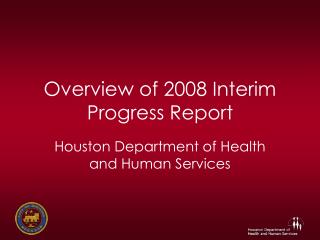
Base MAP of PLAAP Study areas Water District boundary derived from: Massachusetts General Law Acts 1951 Chapter 106 Section 1
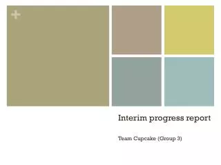
Groundwater Flow and Water Supply Areas Data sources:“Plymouth Lense water table” and “water table flow direction” are digitized from Figure 12 in the "Hydrogeology and Simulation of Groundwater Flow in the Plymouth-Carver-Kingston-Duxbury Aquifer System, Southeastern Massachusetts" report distributed by the USGS.Public Groundwater sources and supplies data from State of Massachusetts GIS. Vernal Pools and buffers from NHESP
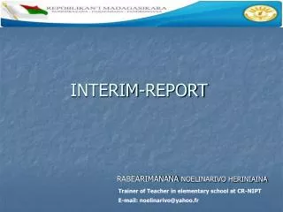
Identified Water Supply Protection Areasand Buffers Includes Zone II sites: Wellhead protection areas or areas of contribution, approved by the MA DEP under a rigorous “new source approval” program. These are the areas of land receiving the rainfall that replenishes the portion of the aquifer from which a well derives its water.
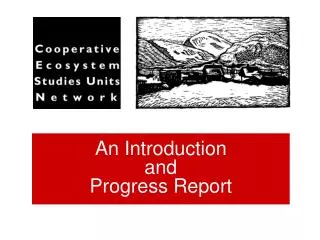
Water Supply Obstacles Additional Data sources: Public Water Supply Zone 2 sites from the State of Massachusetts GIS.
Task 4 – ASSESS existing wastewater infrastructure Sub-Tasks: • Review Inter Municipal Agreement (IMA) • Summarize allocation issues • Develop outline for allocation tracking December | 6 | 2011
ASSESS EXISTING WASTEWATER INFRASTRUCTURE December | 6 | 2011
ASSESS EXISTING WASTEWATER INFRASTRUCTURE December | 6 | 2011
Existing Allocation • Allocation allowed by permit • Board of Sewer Commissioners approves permit • One extension of permit is allowed • Currently one allocation permit is granted (23,000 GPD to Optimus Senior Living) • Allocations are tracked by the Town of Bourne Building/Inspection Department December | 6 | 2011
Task 5 – Build-out Sub-Tasks: • Identify study area locations • Buzzards Bay (DTD) • Bourne Development Campus • Hideaway Village • Compile data and assumptions • Develop build-out scenarios • Existing constraints • Unlimited infrastructure constraints • Phased optimized design December | 6 | 2011
What is a Build-Out Analysis? • What it is: • Theoretical development scenario • Snap shot of development potential under zoning • Involves flexible assumptions • Maximized development scenario • Community visioning tool • What it isn’t: • Actual future development • Parcel by parcel analysis December | 6 | 2011
Buzzard Bay Downtown District (DTD) Downtown Gateway (DTG) Downtown Core (DTC) Downtown Neighborhood (DTN) Downtown Waterfront (DTW) December | 6 | 2011
Build-out Data & Assumptions By right: • 4 stories • 80% lot coverage • Parking req. by use • Input assessors data (2006) • Overlaid DTD form based code (zoning) • Removed open space, municipal uses & wetlands • Overlaid FEMA floodplain • Assumed mix of uses: • 40% Commercial, 60% Residential (DTG & DTC) • 30% Commercial, 70% Residential (DTW) • Restaurant • Office • Retail • Hotel • Institutional • Consumer Services December | 6 | 2011
BFDC & Hideaway Build-out December | 6 | 2011
Build-out Development PotentialTheoretical vs. Practical DTD Theoretical Build-out DTD Practical Build-out (20% of Theoretical) December | 6 | 2011
QUESTIONS/COMMENTSProject Team BWAC CCC RESET Glenn Cannon - Director Technical Services Tom Cambareri - Water Resources Program Manager Tabitha Harkin - Special Projects Coordinator Sharon Rooney - Chief Planner Ryan Christenberry - Planner II Anne Reynolds - GIS Manager Sallie K. Riggs, Chairman Stanley Andrews Michael Brady William Locke Mary Andrews December | 6 | 2011