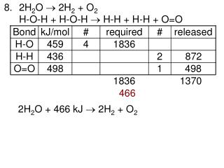
Download
1 / 31
310 likes | 427 Views
Design of the Western Part of Nablus Ring Road. “ Moh’d Bin Rashid Al-Maktom Road ”. Nablus – Palestine May 2009. Prepared by Hakam J. Aaraj Qadri H. Shaheen Mutaz H. O’deh Under the supervision of Prof. Dr. Sameer A. Abu- Eisheh. INTRODUCTION.

E N D
Design of the Western Part of Nablus Ring Road “ Moh’d Bin Rashid Al-Maktom Road ” Nablus – Palestine May 2009 Prepared by Hakam J. AarajQadri H. Shaheen Mutaz H. O’deh Under the supervision of Prof. Dr. Sameer A. Abu-Eisheh
INTRODUCTION • Nablus city, one of the main commercial centers in the West Bank, suffers from high congestions in CBD because it lies between two mountains. • Nablus connects the northern cities (Jenin, Tulkarem, Qalqilya, Haifa, etc.) and the southern cities (Ramallah, Jerusalem, Hebron, etc.). • The construction of a Ring Road around Nablus is essential for solving the congestions problem in Nablus CBD. • This project is concerned with the design of the Western Part of Nablus Ring Road.
The Western Part of Nablus Ring Road connects Nablus-Qalqilya Street south west of Nablus City with Nablus-Tulkarem Road in the west. It also extends to Asira Al-Shamaliya Road north of Nablus connecting An-Najah University New Campus with the University Educational Hospital.
OBJECTIVES • Development of well planned and well connected urban built-up areas around the city. • Solve the congestions and delays that face the traffic movement to and from An-Najah University.
Data Collection and Traffic Studies Design Criteria Evaluation of Existing Design Cross Sections Horizontal Alignment Geometric Design Vertical Alignment Design of Intersections TCD Reporting
RECONNAISSANCES • Examine the constructed and non constructed segments of the road. • Snap pictures of the area from different parts of the road, including the intersections and critical sections. • Collect maps and drawings.
TRAFFIC STUDIES • Diverted Traffic The traffic that diverts to the road from an alternative road with the same origin and destination. • Developed Traffic The traffic that affect the volume after constructing the road or will be developed with time. • Natural Growth Traffic The traffic forecasted for the design year, considering proper growth in traffic, normally 20 years from the project date.
DIVERTED TRAFFIC • The Western Traffic Directed to the New Campus of An-Najah National University: Directional peak hour (PH) from 7:00 am – 8:00 am with PHV 120 veh/hr towards the University New campus. • University Employees Housing to and from An-Najah University: Counted at 130 families, 50% go to the New Campus (PH=65 veh/hr). • Through Traffic Diverted to Use the Ring Road Towards Nablus East: 554 veh/hr towards Nablus (Counted at Zawata Intersection) 292 veh/hr through traffic at Faisal St. 10% DT Al-Quds St. (PH=56 veh/hr) / 5% towards Amman St. (PH=28veh/hr)
NEWLY DEVELOPED • Counted Traffic from nearby Residential Areas Intersection: PH was formed to be from 7:00 am – 8:00 am with PHV 33 veh/hr. • Residential Trips Estimating: North Segment 880 veh/hr South Segment 805 veh/hr • AL-Watani Hospital Trips Estimating: Jenin = 26 veh/hr Tulkarem = 10 veh/hr Qalqilua = 15 veh/hr • An-Najah University Medical Complex Trips Estimation: 40 trip during PH
NATURAL GROWTH TRAFFIC The annual traffic growth factor applied in this project is 2.53% The annual population growth factor is applied, which is 3.5% The University growth factor for the traffic volume is 1.2 • The Western Traffic Directed to the New Campus of An-Najah National University. • Through Traffic Diverted to Use the Ring Road Estimate Towards Nablus East. • AL-Watani Hospital Trips Estimating. • An-Najah University Medical Complex Trips Estimation
THE EXISTING DESIGN Horizontal Alignment Evaluation E = R (1/cos(∆/2) – 1) Reference Criteria 50 km/hr Rmin 80m
THE EXISTING DESIGN Vertical Alignment Evaluation • Manual estimate for grades (G1, G2). • Manual estimate for lengths (L). • Calculate K K= (L/g2-g1) Crest (min) k=7 Sag (min) k=13
THE EXISTING DESIGN • Limited radii of curves which aren’t suitable for design speed and the road classification. • Profiles has been drawn manually. • 35% of distance of the road does not match the standards. • The slope is very high in some stations; up to 17%.
DESIGN CRITERIA • Urban Arterial Road (Two Lane per Direction). • Design speed 70 km/h • Min. Radius = 175m • e = 8% • Max. Grade = 9% • fs = 0.14 • Design Vehicle WB-19 The level of service is “C”
pavement design • Design ESAL = 1.6 *106 • CBR = 20% • SN = 2.2 • Asphalt = 6 cm • Base Course = 20 cm • No Sub Base
CROSS SECTION STRUCTURE RESIDENTIAL AREA TYPICAL CROSS SECTION (WITH SIDEWALKS) FROM STATION 0+00.00 TO 8+00.00 FROM STATION 30+00.00 TO 49+11.39
CROSS SECTION STRUCTURENON RESIDENTIAL AREA TYPICAL CROSS SECTION (WITH SHOULDERS) FROM STATION 8+00.00 TO 30+00.00
CONCLUSIONS • Decrease the congestion problem in Nablus CBD. • The proposed ring road route has rough terrain, which makes the design process more critical. • It was very difficult, even impossible, to meet the design requirements for a highway at the proposed ring road route and site. The topography of the site is very difficult and is not suitable. • It was necessary to fill few segments of the ring road by layers of rocks where the depths of fill are high and the side slopes do not align the existing ground level.
RECOMMENDATIONS • It is recommend considering other alternative routes for the ring road that has less steep grades and less steep area. This will reduce the volume of cut and fill. • An alternative alignment (Align. 2) for the ring road has been considered and is recommended. • It is recommended to adopt surveying points as reference for the elevations and not to use the contours for the design. The surveying points available at Nablus Municipality were not made available.
THANKS FOR YOUR LISTENING WITH OUR REGARDS