Download
1 / 32
330 likes | 489 Views
Regional Oceanography II . OEAS 604. Lecture Outline Atlantic Ocean circulation Indian Ocean circulation Chapters 8,9 – Knauss Chapter 9,11 – Talley et al. Westerlies – 30-60 latitude Trade Winds – from east Intertropical Convergence Zone (Doldrums) . Annual Mean Wind Field.

E N D
Regional Oceanography II OEAS 604 • Lecture Outline • Atlantic Ocean circulation • Indian Oceancirculation • Chapters 8,9 – Knauss • Chapter 9,11– Talley et al.
Westerlies – 30-60 latitude Trade Winds – from east Intertropical Convergence Zone (Doldrums) Annual Mean Wind Field
East and west basins separated by Mid-Atlantic Ridge Connection to Arctic and Southern Ocean NADW formation in Greenland, Norwegian and Labrador Seas
Antarctic Bottom Water Pathways Different varieties along western and eastern sides of basin Limited across basin exchange Flow on eastern side blocked by Walvis Ridge
AAIW Depth of Minimum Salinity
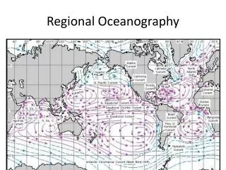
Atlantic Ocean Current Structure • Subtropical gyres in both hemispheres • Eastern and western boundary currents • Subpolar gyre in northern hemisphere • Equatorial current system • Connection to Arctic • Connection to Southern Ocean
Western Boundary Currents Gulf Stream, Brazil Current Eastern Boundary Currents Canary Current, Benguela Current Equatorial Current System North Equatorial Current Equatorial Countercurrent South Equatorial Current Subpolar Gyre North Atlantic Current Irminger Current East and West Greenland Currents Labrador Current
Gulf Stream Deep current High velocity High transport Brazil Current
Gulf Stream Variability Branches – North Atlantic Current, Azores Current Sargasso Sea
Gulf Stream rings Warm core ring Cold core rings Cold core ring location
Canary Current – eastern boundary current Shallower Lower velocity Upwelling
Temperature section across Equator in Atlantic Ocean
South Atlantic Current System
Gulf of Mexico Loop Current – spin off eddies
Mediterranean Outflow Temperature at 1000 m Salinity at 1000 m
Water Masses - Mediterranean LIW - Levantine Intermediate Water
Indian Ocean Blocked to north Wind patterns change direction with season (monsoon) Circulation in northern Indian Ocean changes direction every six months
Northeast Monsoon • Northern winter (Dec-Feb) cooling of Siberia and Central Asia land mass – greater than cooling of ocean • Atmospheric high pressure forms over land and develops polar continental air mass that sets up pressure gradient that directs winds from land towards sea – cold dry air • Over Africa have trans-equatorial meridional atmospheric pressure gradient (high north, low south) that directs wind into Indian Ocean • Blocks the southward extent of NE monsoon – usually does not cross about 10°S
Southwest Monsoon • Northern summer (June-Aug) warming of southern Eurasia and North Africa land mass • Atmospheric low pressure forms that directs winds from sea to land – pick up moisture • Strong southwest winds blow over the Arabian Sea and Ba of Bengal carrying considerable water vapor – produces the summer rains
Northeast Monsoon Southwest Monsoon
Agulhas Current Western boundary current
Australian Mediterranean Sea
Australian Mediterranean Sea February August
Next Class • Continue Currents and Water Masses • Pacific Ocean – Chapter 10, Talley et al. • Ocean-atmosphere coupling, Climate change – Chapter 14, Talley et al. • Quiz – Thursday, 14 November