Download

1 / 29
681 likes | 3.64k Views
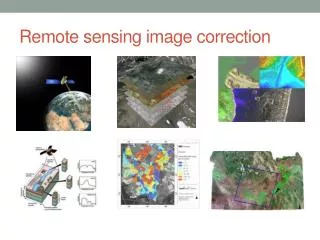
Remote Sensing Image Rectification and Restoration. Image Rectification and Restoration. Geometric correction Radiometric correction Geometric restoration. 1. Geometric Correction. For raw image rectification For multi-date images registration

E N D
Image Rectification and Restoration • Geometric correction • Radiometric correction • Geometric restoration
1. Geometric Correction • For raw image rectification • For multi-date images registration • For multi-resolution images or data layers registration • Systematic distortion vs. random distortion
Skew Correction Coordinate transfer Pixel value resampling http://rst.gsfc.nasa.gov/Intro/Part2_15.html
Ground Control Points (GCP) • Features with known locations on a map (X,Y coordinates). These are the “ground control points” • The same features can be accurately located on the images as well (column, row numbers) • The features must be well distributed on the map and the image • Highway intersections are commonly used ground control points
Coordinate Transform • Coordinate transform equations relate geometrically correct map coordinates to the distorted image coordinates x = a0 + a1X + a2Y y = b0 + b1X + b2Y x,y: column, row number X,Y: coordinates • Root Mean Square Error (RMSE) = √(dx)2 + (dy)2 Calculate RMSE for all control points
Resampling • The purpose is to assign pixel values to the empty pixels in the rectified matrix output • Superimpose the rectified output matrix to the distorted image • The digital number (DN) of a pixel in the output matrix is assigned based on the DN of its surrounding pixels in the distorted image
Re-sampling Methods • Nearest neighbor resampling • Bilinear interpolation • Cubic convolution resampling
Nearest Neighbor Resampling • The DN of a pixel in the output matrix is assigned as the DN of the closest pixel in the distorted image • Advantages simple computation maintain the original values • Disadvantage spatial offset up to 1/2 pixel
Bi-linear Interpolation • Distance-weighted average of DN values of the closest 4 pixels • Advantage output image is smoother than the nearest neighbor method • Disadvantage alters the original DN values
Cubic Convolution Resampling • Uses DN values of the closest 16 pixels, adjusted by distance • Advantage smooth output image • Disadvantage alters the original DN values
When to Rectify • Rectify before image classification • Rectify after image classification
2. Radiometric Corrections Radiometric responses differ by • dates • sensor types • images • Causes: - Illumination - Atmospheric conditions - View angle or geometry - Instrument response
Radiometric Corrections • Sun elevation correction • Atmospheric correction • Conversion to absolute radiance
Sun Elevation Correction DN • -------------------------------- Sin (Sun elevation angle) • Assuming the terrain is flat
Satellite Summer Zenith Spring / Fall Solar Elevation Angles Winter Tangent plane Equator
Atmospheric Correction • Haze compensation The DN value of an object (e.g., a deep clear water body) with 0 reflectance = Lp • Subtract the DN from the entire band
Absolute Irradiance • Conversion of DN values to absolute radiance values • It is necessary when compare different sensors, or relate ground measurements to image data • L = (Lmax- Lmin)/255 * DN + Lmin
3. Geometric Restoration • Stripping • Line-drop • Bit errors
Striping • Malfunction of a detector • Use gray scale adjustment to correct the strips
Line Drop • using average of the above and below lines to fill the dropped line
Bit Error • Salt and pepper effect due to random error • Use 3x3 or 5x5 moving window average to remove the noise
Readings • Chapter 7
Earth-Sun Distance Correction E0 Cosq0 • E = ------------ d2 • Irradiance is inversely related to the square of the earth-sun distance • E - normalized solar irradiance • E0 - solar irradiance at the mean Earth-sun distance • q0 - sun angle from the zenith • d - Earth-sun distance
Atmospheric Correction rET • Ltot = --------- + Lp p r - reflection of target E - irradiance on the target T - transmission of atmosphere Lp - scattered path radiation