Download
1 / 10
100 likes | 268 Views
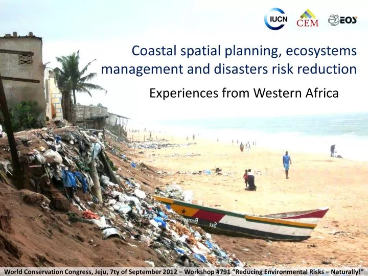
Coastal spatial planning, ecosystems management and disasters risk reduction. Experiences from Western Africa. World Conservation Congress, Jeju , 7ty of September 2012 – Workshop #791 “ Reducing Environmental Risks – Naturally!”.

E N D
Coastal spatial planning, ecosystems management and disasters risk reduction Experiences from Western Africa • World Conservation Congress, Jeju, 7ty of September 2012 – Workshop #791 “Reducing Environmental Risks – Naturally!”
Towards a regional understanding of the coastal risks in West Africa • UEMOA 2007 : regional program to fight coastal erosion • IUCN committed to produce a diagnostic, a map of the coastline and a regional coastal zone management scheme • Collaboration with EOS.D2C, EAM.GEOME, and more than 130 national experts: • Prospective studies on demography, economy and climate • Regional diagnostic, maps, regional and detailed management scheme • 11 national diagnostics • 15 case studies
Origins of the risks • Fast demographic growth and concentration in the coastal areas • Human installations in exposed areas • Fragile coasts • Perturbations of the hydro-sedimentary dynamics (dams, infrastructures, modifying estuaries, coastal protection, etc.) • Extraction of coastal sediments • Destruction of coastal green infrastructures and ecosystems services • Sea level rise and meteorological events
Results and perspectives • A regional diagnostic • 10.000 km of coasts mapped (dynamics, stakes and management scheme) • A management scheme with detailed recommendations for 179 sectors • Next steps: • A GIS and a long term regional monitoring system of coastal risks for West Africa • Strengthening governance and actors’ capacities • Link strongly coastal spatial planning and disaster risks reduction • Integrating ecosystem management, restoration and conservation
Coastal ecosystems, land use planning and disasters risk reduction • Three case studies: • Nouakchott, Mauritania: Importance of preserving sand ridges to prevent the flooding of the capital • Banjul, The Gambia: Conserving mangroves to reduce the impacts on infrastructures • Abidjan, Ivory Coast: The coastal wetlands and lagoons for adaptation to sea level rise and water supply
Nouakchott, a capital under the sea level • Preserve the coastalsandridge to preventfloodings
Banjul, the mangrove to slow down the effects of coastal erosion • The mangroves capture the sediments contributing to stabilize the coast
Abidjan, wetlands reducing the impacts of coastal erosion and supply water • The coastal lagoons provide water to Abidjan and reduce coastal erosion, migrating backwards where the lido has not been heavily artificialized
Next steps concerning PACO and GMPP / Global Coasts • Do the same job in Central Africa (CEMAC ?) • Develop a flagship product for the Global coast program: Coastal Spatial Planning • Collaborate to similar approaches in other regions (Asia, ESARO) and methodologies (R2R, etc.) • In collaboration with CEM and DRR program in HQ
Lessons learnt and recommendations • Territorial prospective is a necessary approach • Why insisting on DRR approaches ? • Maximum political audience • Multidisciplinary and prospective, technically exigent • access to new funding mechanisms (adaptation funds, WB GFDRR, etc.) • A strong justification for coastal & marine PAs and ecosystem based management • Need further integration with ecosystem management, restoration and conservation • IUCN has a DRR network already : CEM, EOS.D2C, EAM-GEOME • Need for a proactive Specialized Thematic Group in CEM on DRR with key areas - including coastal, proposing a set of diverse expertise easy to mobilize, flagship approaches and capitalization products