Download
1 / 18
180 likes | 288 Views
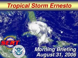
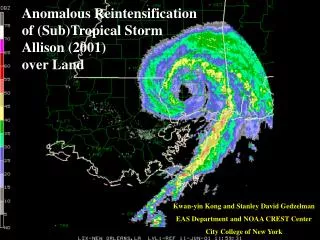
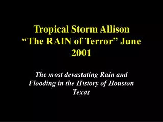
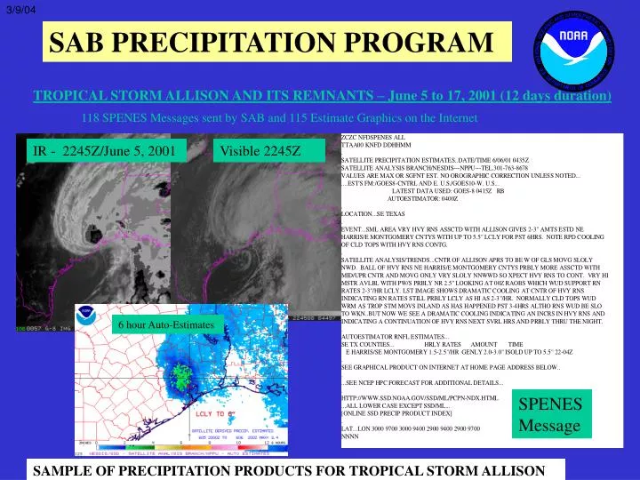
3/9/04. SAB PRECIPITATION PROGRAM. TROPICAL STORM ALLISON AND ITS REMNANTS – June 5 to 17, 2001 (12 days duration). 118 SPENES Messages sent by SAB and 115 Estimate Graphics on the Internet. IR - 2245Z/June 5, 2001. Visible 2245Z. 6 hour Auto-Estimates. SPENES Message. SPENES Message.

E N D
3/9/04 SAB PRECIPITATION PROGRAM TROPICAL STORM ALLISON AND ITS REMNANTS – June 5 to 17, 2001 (12 days duration) 118 SPENES Messages sent by SAB and 115 Estimate Graphics on the Internet IR - 2245Z/June 5, 2001 Visible 2245Z 6 hour Auto-Estimates SPENES Message SPENES Message SAMPLE OF PRECIPITATION PRODUCTS FOR TROPICAL STORM ALLISON
WHY ARE SATELLITE RAINFALL ESTIMATES USED/NEEDED? • SUPPLEMENTS RADAR AND RAIN GAUGES– where there is inadequate rain gauge coverage, no radar coverage, or missing radar coverage • SPATIAL CONSISTENCY – only one instrument (GOES satellite) to calibrate rather than multiple radars. Thus there are no calibration differences, range effects, or beam block problems that can occur with radar.
HISTORY OF IFFA/QPE OPERATION • 1979FirstEstimates • 1983 - Fully Operational - using McIDAS system - SPENES messages on AFOS • 1993 - Collocated with NCEP/HPC, forming NPPU - better QPF support • 1996 - Estimate Graphics and SPENES messages on Internet - SSD Web Page • 1997 - Orographic Correction added - for short-term estimates • 2000 - Combined IFFA/Auto-Estimator Operation • 2002 – Hydroestimator – new version of Auto-Estimator
Satellite Analysis BranchPrecipitation Products and Services For WSFO’s and RFC’s (lower 48 states; Puerto Rico): 1) Satellite Precipitation Estimate Messages (SPENES) 2) Satellite Precipitation Estimate Graphics ..…For Heavy Precip.,especially Flash Flood Events For Hydrometeorological Prediction Center (HPC): Satellite Briefings and Precipitation Estimates
SPENES Contents 1. IFFA/Autoestimator/Hydroestimator Rain Est. (Hourly rates; 1, 3, 6, 24 Hour Totals Satellite Data Used: GOES IR, VIS, WV GOES Sounder and Imager Data and Derived Product Imagery (DPI) GOES Satellite Winds Microwave: DMSP SSM/I (rain rates and PW) NOAA AMSU (rain rates, PW) NASA TRMM (rain rates) 2. Satellite Analysis and Trends (and nowcast)
Additional Input for SPENES’s • Surface and Upper Air Data and Analyses • Radar – NAWIPS and McIDAS • Model Data - from AWIPS and NCEP NAWIPS • Experimental Blended Products - satellite and model data • Internet Data
ZCZC NFDSPENES ALL SPENES TTAA00 KNFD DDHHMM . SATELLITE PRECIPITATION ESTIMATES..DATE/TIME 01/29/04 1130Z SATELLITE ANALYSIS BRANCH/NESDIS---NPPU---TEL.301-763-8678 VALUES ARE MAX OR SGFNT EST. OROGRAPHIC CORRECTION IN AUTO-ESTS.. EST'S FM:/GOES12-CNTRL AND E. U.S./GOES10-W. U.S... LATEST DATA USED: GOES-12 0215Z GALLINA . LOCATION...NEW YORK... . EVENT...VERY STRONG LES OFF LK ONTARIO/QUIETED DOWN OFF LK ERIE... . GOES ANALYSIS AND TRENDS...UPDATE FROM LAST SPE...AREA OF COOL CLOUD TOPS ASSOCIATED WITH LAKE ERIE LES HAS BECOME LESS IMPRESSIVE AND HAS DIMINISHED IN SIZE AND IS REALLY ONLY RELEGATED TO CHAUTAUQUA AND CATTARAUGUS COUNTIES IN WESTERN NY. TOTALS UP TO 2.6 HAVE BEEN ESITIMATED IN S ERIE. ELSEWHERE...WAVERING WIND DIRECTION HAS DECREASED THE WIDTH OF THE VERY LONG LAKE EFFECT WEST-EAST BAND NEAR THE EASTERN SHORE OF THE LAKE INTO OSWEGO COUNTY. RATES ARE STILL QUITE HIGH AND 6 HOUR TOTALS ARE UP TO 5.6". INTERESTING TO NOTE AT THIS POINT IS THE PERSISTENT COOLING TOPS JUST NORTH OF MONROE AND ORLEANS COUNTIES. THIS AREA HAS HAD INCREASED FETCH DUE TO SEEDING FROM THE LAKE EFFECT PLUME FROM ST. GEORGES BAY ACROSS ONTARIO CANADA. IF THIS PLUME WERE TO MOVE ONSHORE...ESTIMATED RATES WOULD BE UP TO 3.5"/HR USING THE LES IR TECHNIQUE. NOTE ON THE GRAPHIC...THERE ARE HIGH ESTIMATES IN ORLEANS COUNTY ALREADY...BUT THIS IS AN EFFECT OF PARALLAX CORRECTIONS AND SHOULD BE SHIFTED ABOUT A HALF COUNTY NORTH. . IFFA LAKE EFFECT SNOW ESTIMATES... 6 HR SNOW TOTALS TIME C NY...OFF LAKE ONTARIO... N OSWEGO 5.6" 0515Z-1115Z S JEFFERSON 3.9" N ONEIDA 3.3" N ORLEANS 2.2" W NY...OFF LAKE ERIE... S ERIE (BOARDER WITH CATTARAUGUS) 2.6" " CHAUTAUQUA 2.3" " CATTARAUGUS 2.3" " . GRAPHIC FOR THIS EVENT IS CURRENTLY ON THE INTERNET AT ADDRESS BELOW. . 1 HOUR HYDRO-ESTIMATOR TOTALS ARE AVAILABLE ON AWIPS UNDER 1 HR AUTO SPE . HTTP://WWW.SSD.NOAA.GOV/PS/PCPN/ ...ALL LOWER CASE EXCEPT PS/PCPN... [ONLINE SSD PRECIP PRODUCT INDEX] . LAT...LON 4400 7900 4500 7400 4300 7500 4200 8000 NNNN Example of SPENES with manual IFFA estimates for Lake Effect Snow
ZCZC NFDSPENES ALL SPENES TTAA00 KNFD DDHHMM . SATELLITE PRECIPITATION ESTIMATES..DATE/TIME 03/04/04 1155Z SATELLITE ANALYSIS BRANCH/NESDIS---NPPU---TEL.301-763-8678 VALUES ARE MAX OR SGFNT EST. OROGRAPHIC CORRECTION IN AUTO-ESTS.. EST'S FM:/GOES12-CNTRL AND E. U.S./GOES10-W. U.S... LATEST DATA USED: GOES-12 1145Z TEB . LOCATION...OKLAHOMA . ATTN WFO'S...OUN...ICT . EVENT...CONVECTION. . SATELLITE ANALYSIS AND TRENDS...LATEST IR IMAGERY SHOWS EXPANDING CLOUD TOPS ASSOCIATED WITH A NORTHWARD MOVING LINE OF CELLS. WV AND SOUNDER DATA SHOWS THESE CELLS TO BE DEVELOPING NORTH OF THE DEEP MOISTURE ASSOCIATED WITH THE PLUME SHOOTING NORTHWARD THROUGH EASTERN TEXAS INTO EASTERN OKLAHOMA. THE HYDROESTIMATOR SUGGESTS HRLY RATES UP TO 1.4" THRU 1130Z MAINLY FROM OKLAHOMA INTO LINCOLN CNTYS IN CENTRAL OK. HOWEVER WITH DEWPOINTS RISING QUICKLY OVER THE PAST SEVERAL HOURS AND AFOREMENTIONED PLUME TRANSPORTING RICH, DEEP MOISTURE NORTHWARD...FFG RATES MAY BE REACHABLE ESPECIALLY IN THE NORTH AND NORTHEASTERN COUNTIES OF OK AND S.E. KS. WILL CONTINUE TO MONITOR. . AUTOMATED SATELLITE HYDROESTIMATES OK CNTYS... TOTAL TIME N.E. OKLAHOMA 1.9" 0830-1130Z . SEE GRAPHIC OF AUTOMATED SATELLITE ESTIMATES AT WEB ADDRESS LISTED BELOW . 1 HR HYDRO-ESTIMATOR TOTALS ARE ON AWIPS UNDER 1 HOUR AUTO SPE . ..NESDIS SAB HAS BEEN ADDED TO 12 PLANET... . SEE NCEP HPC DISCUSSION AND QPF/S FOR FORECAST . HTTP://WWW.SSD.NOAA.GOV/PS/PCPN/ ...ALL LOWER CASE EXCEPT PS/PCPN... [ONLINE SSD PRECIP PRODUCT INDEX] . LAT...LON 3800 9900 3800 9600 3500 9600 3500 9900 NNNN Example of SPENES message with automated satellite Hydroestimates
Automated Hydroestimator Graphic posted on Web Page - EXAMPLE
Hydroestimator Products at NESDIS • Every 15 Minutes: • Instantaneous Rate • 1 hour totals • 3 hour totals • 6 hour totals • Daily (12Z): • 24 hour totals
Factors in Derivation of HYDROESTIMATES • 15 min imagery • Cloud top temperature • Original AE…Radar reflectivity for rain/no rain • Hydro-Estimator (Auto SPE on AWIPS)…no radar - uses satellite-based screening technique • Moisture correction – (Precipitable Water and RH) • Orographic correction • Warm cloud tops/equilibrium level adjustment • Parallax (satellite viewing angle)
Click on “NCEP/Hydro” on Menu Bar To Access the Pull Down Menu 1 hr Auto SPE Manual SPE Example of AWIPS Hydro-Estimator graphic, Called “1 hr Auto Satellite Precip Estimates” (SPE)
Hydro-Estimator vs. Manual IFFA • Manual IFFA (Interactive Flash Flood Analyzer): • Satellite-derived Precip Estimates determinedby satellite meteorologist • - uses cloud toptemp, PWxRH, warm top correction, etc, experience, cloud top temp change and growth, cell mergers, and rain burst. • Computer (McIDAS) stores and totals estimates • Hydroestimator (New version of Autoestimator) : • Satellite-derived Precip Estimates determinedby computer (algorithm) • - uses cloud top temp, PW&RH, warm top correction, etc, does not usecloud top temp change and growth, cell mergers, or rain burst.
Future Hydro-Estimator Improvements:Current or Planned Testing….. • Rain Burst – increase amounts for 1st hour • Cloud Top Cooling and Growth • Single Channel → Multi-channel sensor - (GOES Channels; Microwave; other algorithms) • Use of GOES Sounder PW, RH, Equil. Level • Improved Calibration of H-E rain rate curves • Nowcast Version of H-E (0-3 hr rainfall fcst) • Validation Efforts: H-E vs Stage III & Gages
Web Sites for NESDIS Satellite Estimates • Satellite Services Division (SSD) Home Page - SAB Operational Products • http://www.ssd.noaa.gov/PS/PCPN - Satellite Precipitation Estimate Messages (SPENES) - Auto Satellite Precip Estimates or Interactive Flash Flood Analyzer (IFFA) graphics • ORA Flash Flood Home Page - Multi-hour Hydro-Estimator Products • http://orbit-net.nesdis.noaa.gov/arad/ht/ff/index.html