Download
1 / 65
650 likes | 758 Views
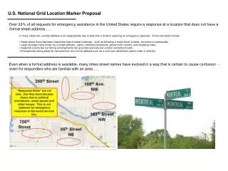
Practical Applications Of The U.S. National Grid In Minnesota. Randy Knippel Dakota County. Agenda. National Grid Maps Standardized fire maps Overview of National Grid Web resources Places to start Data and tools ArcGIS Tools, tips, and tricks. Standardized Fire Maps. Randy Knippel

E N D
Practical Applications Of The U.S. National Grid In Minnesota Randy Knippel Dakota County
Agenda • National Grid Maps • Standardized fire maps • Overview of National Grid • Web resources • Places to start • Data and tools • ArcGIS • Tools, tips, and tricks
Standardized Fire Maps Randy Knippel Dakota County
Street Index Dana Dr.
United States National Grid(USNG) • National standard since 2001 • Adopted by federal agencies • FEMA, DHS, NGA, USGS • Adopted by several states • Florida, Missouri, North Carolina, others • Minnesota (March 25, 2009) • Military Grid Referencing System • Metric system
Why? • Multiple grids • Needed one for everyone • Need efficient location referencing • Need interoperability • Across jurisdictions • Local, state, federal, military
What about Lat / Long? • Not intuitive • Degrees, minutes, seconds • Several formats • DMS, DMS.sss, DM.mmm, D.ddd • Longitude • + / - • West / east • Increases left to right
What about Lat / Long? • How big is a degree? • It varies • 69 miles at the equator • Longitude gets smaller toward poles • 50 miles in Dakota County • Distance calculations are difficult
10 Km Squares USNG:15T VK 75
Three Components • 18SUJ2337106519 • 18S UJ 23371 06519 • 18SUJ23370651
MapVK75 7456
Map7456(15T VK 74 56) 741565(15T VK 741 565)
Truncating • USNG:15T VK (100Km square) • VK is unique for 800 miles in any direction
Scalable National Regional Local
Precision and Truncation • 18SUJ2337106519 • 18S UJ 23371 06519 • 1 meter precision, full USNG designation • UJ2306 • Assume GZD (18S) • UJ – 100,000 m precision (100 km square) • 23 06 – 1000 m precision (1 km square) • 2337 0651 • 10 m precision • Assume GZD and 100 km square
Key Resources Critical Infrastructure Vulnerable Population
www.gis.state.mn.us 14TPS 7096 PS79
National Spatial Data Infrastructure (NSDI)Cooperative Agreement Program (CAP) • Category 5: Building data stewardship • Schools • Hospitals / clinics • Police stations • Fire stations
Tying It All Together • Put USNG on maps! • Define standard map products • Seamless across jurisdictions (?) • Include critical assets / key resources • Structures • Create supporting documents • Training