Download

1 / 14
140 likes | 243 Views
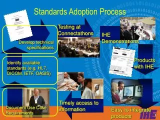
GEO-IDE Standards Process. Denver Post, Sunday, 9 April 2006. GEO-IDE Community Building and Best Practices Process. GEO-IDE Principle #6.

E N D
GEO-IDE Standards Process Denver Post, Sunday, 9 April 2006 GEO-IDE Community Building and Best Practices Process
GEO-IDE Principle #6 Standards and practices: Appropriate use of information technologies, widely shared standards, and integration approaches are vital to facilitate collection, management, discovery, dissemination, and access services for environmental data and products. This will ensure interoperability among providers, systems, and users. Effective application of standards and best practices contribute to the development of systems that are interoperable, efficient, reliable, scalable, and adaptable.
Goal Increase Communication and Sharing Build on Running Code Organize Around Data Types 1 2 3 The goal of the GEO-IDE Community Building and Best Practices Process (CB2P2) is to facilitate the creation and development of communities of practice in NOAA that can share expertise, experience, and data. These communities are integral to cost effective data management and to participation in an integrated international data environment.
Data Types Atmospheric Observations Land Surface Observations Ocean Observations Space Observations Metadata Multi-dimensional fields Multi-dimensional fields Time Series Time Series Points Points Profiles Profiles Grids Grids Geospatial Framework Data Geospatial Framework Data Trajectories Trajectories
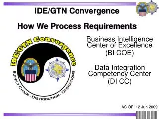
Increase Communication with the Data Management Committee and other managers with other standards processes (NOAA TRM, NOAA IOOS, NASA, FGDC, IOOS, GEOSS, OGC, ISO, Vendors, Universities) with the NOAA Data Management community
External GEO-IDE Partners International International Support Architecture and Data Committee Support Strategic Implementation Team (SIT) and the Working Group on Information Systems and Services (WGISS) NOAA National National Support Architecture and Data Management Group and provide Executive Secretariat for Strategic Assessment Group Support IOOS Integrated Product Team 10
GEO-IDE ’10 - Unified Access Framework DAP ERDDAP WCS WMS Multiple Analysis and Visualization Clients Capabilities Grids THREDDS - One Catalog to Unite Them All Metadata New Gridded Datasets, Other Common Data Model Data
NewThink Think about Communities and Best Practices Think about data types Share ideas and practices across NOAA: Join the GEO-IDE Community If you are using OGC Standards: Add them to the Wiki so I can talk about them at the OGC and Meteorology Meeting next month! https://www.nosc.noaa.gov/dmc/swg/wiki