Download
1 / 9
90 likes | 223 Views
Linked Data Geo Vocabulary Background GeoVoCampDC2011 03 June 2011. Todd Pehle tpehle@orbistechnologies.com. Linked Data Geo Vocabularies. The Need for Geo Vocabularies in Linked Data The Lack of Geo Vocabularies in Linked Data The Linked Locations Story So Far

E N D
Linked Data Geo Vocabulary BackgroundGeoVoCampDC2011 03 June 2011 Todd Pehle tpehle@orbistechnologies.com
Linked Data Geo Vocabularies • The Need for Geo Vocabularies in Linked Data • The Lack of Geo Vocabularies in Linked Data • The Linked Locations Story So Far • How GeoVoCampDC2011 Can Help
The Need For Geo Vocabularies in theWeb of Linked Locations • Linked Data + Location Data = Linked Locations • Web of Linked Locations: A spatiotemporal projection of the Web of Linked Data (a global spatial KB) • Web of Linked Locations: Horizontally interlinks the Geo Web & vertically links the Semantic Web & Geo Web • To build a Web of Linked Locations we need: • Linked Data • Geo Data • Query Language (GeoSPARQL) • Tools • Last but not least… A minimal core set of geo vocabulary Building Blocks Orbis Technologies, Inc.
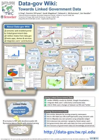
Building the World’s Spatial KB Linked Data exposes thematic attribution & relationships of Linked Locations. Linked Locations inter-connects Geo Web features & bridges Linked Data with Geo Web. Linked Data + Geo Web (vertical links) Geo Web has base vector layers (GIS Data) to be connected to Web of Linked Data. Geo Web Links (horizontal links)
The Lack of Geo Vocabularies in theWeb of Linked Data • FOAF = Person • Organization Ontology = Organizations • OWL-Time = Time • Event Ontology = Events (sort of) • SIOC = Linking online communities, wikis, blogs, etc. • SKOS = Thesauri, classification schemes, taxonomies • Dublin Core = Authoring Metadata • VOID = Vocabulary Of Interlinked Data (Dataset metadata) • Provenance Vocabulary = Lineage, provenance • W3C Basic Geo= 1 Geo Model (GeoSPARQL soon)
The Linked Locations Story So Far • 2006: TimBL posts Linked Data principles • 2006: W3C Geo XG Incubator Group – Produced GeoRSS variant and identified: Features, Types, Toponyms, Spatial Relations, CRS, Metadata, Web Services • 2009: NeoGeoVoCamp – GeoSPARQL conceptually introduced, reviewed GeoXG, created 9-I model • 2010-11: GeoSPARQL (OGC) – Produced minimal geographic feature/geometry plus spatial topology relationships model • 2011: GeoVoCampSouthampton – Scale vocabulary, Nearness vocabulary, Geometry vocabulary, ISO 19115/19139 Metadata, Temporal vocabulary • 2011: GeoVoCampDC2011 – Produced ???
GeoVoCampDC2011 Geo Vocabs • What about “where” do we want to review, extend, create? • Potential ideas for domain-independent modeling: • Review & Identify any needed extensions to GeoSPARQL since it will be a core component (additional semantics or other relations) • Review GeoVoCampSouthampton2011 vocabularies; align with GeoSPARQL • How to align W3C Basic Geo? • Points Of Interest Model: Lightweight feature type/toponym model used to construct/extend feature types (vs. fully define) • Survey/build/extend an events/spatiotemporal model that aligns with GeoSPARQL • Equivalence/disambiguation/similarity links for geographic features • GeoProvenance/GeoVOID • “Linked Data Best Practices” for modeling semantics of multi-part geometries, linear referencing, GPS tracks, routing, others?
Goal: The Linked Locations Core? Events GeoSPARQL Spatial Relations Geometry Feature Types
Topics: • W3C Basic Geo work • SWEET Overview • Topography & Landforms Modeling • ODPs • Bottom-up Methodology / Clustering • Triplifying GeoData • POI/Placename • Land Use Ontology • Geometry Vocab Review/Southampton Vocabs • OSM / LGD • GeoNames/Gazetteer issues