Download
1 / 1
10 likes | 110 Views
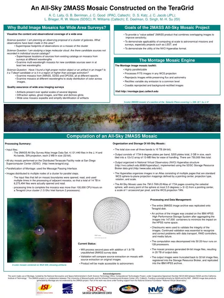
An All-Sky 2MASS Mosaic Constructed on the TeraGrid. A. C. Laity, G. B. Berriman, J. C. Good (IPAC, Caltech); D. S. Katz, J. C. Jacob (JPL); L. Brieger, R. W. Moore (SDSC); R. Williams (Caltech); E. Deelman, G. Singh, M.-H. Su (ISI). Goals of the 2MASS All-Sky Mosaic Project.

E N D
An All-Sky 2MASS Mosaic Constructed on the TeraGrid A. C. Laity, G. B. Berriman, J. C. Good (IPAC, Caltech); D. S. Katz, J. C. Jacob (JPL); L. Brieger, R. W. Moore (SDSC); R. Williams (Caltech); E. Deelman, G. Singh, M.-H. Su (ISI) Goals of the 2MASS All-Sky Mosaic Project Why Build Image Mosaics for Wide Area Surveys? • Visualize the content and observational coverage of a wide area • Science question: I am planning an observing proposal of a cluster of galaxies. What observations have been made in this area? • • Superimpose footprints of observations on a mosaic of the cluster • Science Question: I am studying a large molecular cloud. Are there candidate sources not recorded in individual source catalogs? • • Superimpose locations of sources from existing catalogs on mosaics from • surveys at different wavelengths • • Examine multi-wavelength mosaics for new candidate sources seen in at • least two wavelengths • Science Question: Have I found a high proper motion object or an artifact in an image? Is it a T-dwarf candidate or is it in a region of higher than average extinction? • • Examine mosaics from 2MASS, SDSS and DPOSS, all at different epochs • • Examine mosaics at different wavelengths to study distribution of color across images. • To provide a “value-added” 2MASS product that combines overlapping images to improve sensitivity; • To demonstrate applicability of computing at-scale to astronomical missions and surveys, especially projects such as LSST; and • To demonstrate the utility of the NVO Hyperatlas format. The Montage Mosaic Engine The Montage image mosaic toolkit: • Highly parallelizable • Processes FITS images in any WCS projection • Reprojects images while preserving flux and astrometry • Rectifies variable sky emission to a common level • Coadds reprojected and background-rectified images Visit http://montage.ipac.caltech.edu • Quality assurance of wide area imaging surveys • • Artifacts present over spatial scales of several degrees • • Diffraction spikes, ghost images, and filter and dichroic glints • • Wide area mosaics expedite and simplify identification of artifacts 3-color 2MASS mosaic of a section of the Galactic Plane covering l = 338- 22 º, b= ± 4º Computation of an All-Sky 2MASS Mosaic Organization and Storage Of All-Sky Mosaic: • The total size over all three bands is 10 TB (64-bit). • Output consists of 1734 6-degree plates per band, 5205 plates total, 2 GB in size, each tiled into a 12x12 array of 13-MB files for ease of handling. There are 750,000 files total. • Output organized in National Virtual Observatory (NVO) Hyperatlas structure (http://nvo.caltech.edu:8080/hyperatlas/), implemented using the SDSC Storage Resource Broker data grid (http://www.sdsc.edu/srb/). • The Hyperatlas organizes images in an Atlas consisting of multiple pages that are standard WCS sphere-to-plane projection mappings defined by a pointing center, projection type, rotation, and scale. • The All-Sky Mosaic uses the TM-5-TAN-20 Atlas of 1734 pages covering the celestial sphere, with every point of the sphere at most 3.5 degrees (= 5/√2) from a pointing center, a scale of 1 arcsecond per pixel, and the WCS projection TAN. Processing Summary: • Input files: - The 2MASS All Sky Survey Atlas Image Data Set. 4,121,440 files in the J, H and Ks bands, SIN projection, each 2 MB in size (32-bit). • All-sky mosaic performed on the Distributed Terascale Facility node at San Diego Supercomputer Center (SDSC) (http://www.teragrid.org). • Parallelization of Montage: used the Message Passing Interface. • Images distributed to multiple nodes of a cluster for parallel steps. - The input files that fell on mosaic boundaries were opened, read, and used multiple times in the processing of adjacent mosaics, so that a total of 14 TB in 6,275,494 files were actually opened and read. - processing time to complete the mosaics was more than 100,000 CPU-hours on a Teragrid Linux cluster (1.5 Ghz Intel Itanium 2 processors). Processing and Data Management: •The entire 2MASS image archive was replicated onto Teragrid disk. •An archive of the images was created on the IBM HPSS High Performance Storage System after aggregating the images into 147,000 containers to minimize the impact on the HPSS name space. •Checksums were used to validate the integrity of the images. Continued validation was essential to recognize and correct problems with data transport, RAID controllers, and media failure. •The computation was decomposed into 50 20-hour runs on 128 processors. •The mosaic process generated 64-bit image files, resulting in 20 TB of output data. •The output images were truncated back to 32-bit image files, registered into the Storage Resource Broker, and replicated into the IBM HPSS archive. Current Status: • Will process second pass with addition of 1.8-TB unpublished 2MASS survey data • Validation will compare source-extraction on mosaic with source extraction on original images • Product will be made accessible to astronomers 3-color mosaic centered on Wolf 359, showing artifacts Acknowledgements: This work made use of Montage, funded by the National Aeronautics and Space Administration's Earth Science Technology Office, Computational Technologies Project, under Cooperative Agreement Number NCC5-626 between NASA and the California Institute of Technology.“ The 2MASS project is a collaboration between The University of Massachusetts and the Infrared Processing and Analysis Center (JPL/ Caltech). Funding is provided primarily by NASA and the NSF. 2MASS image data products generated by Montage are not endorsed by the 2MASS project. Part of the work was done under funding support from the National Science Foundation “National Virtual Observatory”.