Download
1 / 26
280 likes | 388 Views
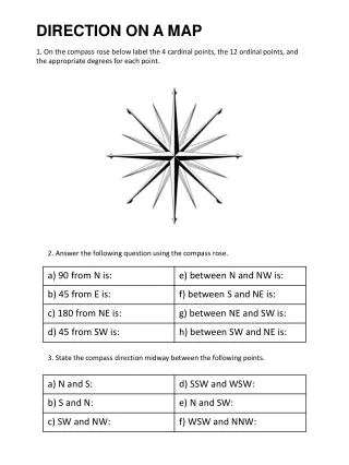
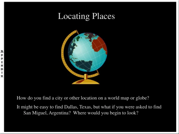
Locating Places on a Map. Cardinal Points. The four main directions of a compass are known as cardinal points . They are north (N), east (E), south (S) and west (W). . Intercardinal (Ordinal) Points. Sometimes, the intercardinal (ordinal) points of: north-east (NE), north-west (NW),

E N D
Cardinal Points • The four main directions of a compass are known as cardinal points. They are north (N), east (E), south (S) and west (W).
Intercardinal (Ordinal) Points • Sometimes, the intercardinal (ordinal) points of: • north-east (NE), • north-west (NW), • south-east (SE) and • south-west (SW) are shown on the compass.
Compass Bearings • This compass shows degree measurements from 0° to 360° in 10° intervals with: • north representing 0° or 360° • east representing 90° • south representing 180° • west representing 270°
Bearing • The true bearing to a point is the angle measured in degrees in a clockwise direction from the north line. We will refer to the true bearing simply as the bearing.
Bearing Example • For example, the bearing of point P is 065º which is the number of degrees in the angle measured in a clockwise direction from the north line to the line joining the centre of the compass at O with the point P (i.e. OP).
360/000o N Half way between North and West Half way between North and East NW NE 270o 090o W E SW SE Half way between South and West Half way between South and East S 180o Compass Points .
Bearings 360/000o N N N N 60o 270o 090o W W W W E E E E S S S S 180o 145o 315o 230o 1. Measured from North. 060o 2. In a clockwise direction. 3. Written as 3 figures. 315o 230o 145o
360/000o 350o 020o N 315o 045o NW NE 290o 080o 270o 090o W E 250o 110o SW SE 225o 210o 135o 160o S 180o Use your protractor to measure the bearing of each point from the centre of the circle. (Worksheet 1) Bearings A 360o protractor is used to measure bearings.
N 360/000o 030o 330o 045o 315o 290o 075o 090o E 270o W Air Traffic Controller 110o 250o Control Tower 135o 225o 170o 200o 180o S Estimate the bearing of each aircraft from the centre of the radar screen. 30-Oct-14
N 360/000o 010o 7 325o 040o Estimate the bearing of each aircraft from the centre of the radar screen. 8 310o 1 ACE Controller contest 060o 11 12 4 280o 2 090o E 270o W 3 5 Air Traffic Controller 250o 10 Control Tower 9 120o 235o 6 195o 155o 180o S Worksheet 2 30-Oct-14
Bearings Measuring the bearing of one point from another. To Find the bearing of Q from P. N P Q 118o 1.Draw a straight line between both points. 2.Draw a North line at P. 3.Measure angle between.
Bearings Measuring the bearing of one point from another. To Find the bearing of P from Q. N P Q 298o 1.Draw a straight line between both points. 2.Draw a North line at Q. 3.Measure angle between.
Bearings: Fixing Position Trainee pilots have to to learn to be cope when the unexpected happens. If their navigation equipment fails they can quickly find their position by calling controllers at two different airfields for a bearing. The two bearings will tell the pilot where he is. The initial call on the controllers radio frequency will trigger a line on the radar screen showing the bearing of the calling aircraft. Airfield (A) 283.2 MHZ UHF 170o 255o Airfield (B) 306.7 MHZ UHF Thankyou
Bearings 000/360o N 270o 090o W E S 180o
Grid Systems • The most common way to locate a place on a map is to use a grid system. • A grid system allows the location of a point on a map (or on the surface of the earth) to be described in a way that is meaningful and universally understood.
Simple Grid System • A simple grid is shown with the location of a point of interest that we want to describe • In order for a point designation on a grid to be meaningful, there must be an origin to the grid which can be used to reference the point to.
Alphanumeric Grid • An alphanumeric grid uses letters and numerals to identify squares on a grid pattern.
Map Grid (Military Grid) • A method to locate points on a map • With this method, a system of numbered lines is superimposed on a map and position is stated by quoting the numbers of the lines that intersect at the point in question.
Using the Military Grid • For instance, let's utilize the military grid to determine which grid square the church is located in.
Identifying Grid Squares - Easting • First, go to the Western edge of the grid square that the object is in first. Then from that western edge, go up or down until you come to a number. In this case, going up or down yields the number 91. These are the first two digits for the square that the church is in.
Identifying Grid Squares - Northing • Secondly, go to the Southern edge of the grid square that the object is in. From that southern edge, go across until you come to a number. In this case, the number is 94. This represents the third and fourth digits for the square that the church is in. • Hence, the church is in grid square 9194
Six Digit Military Grid Method • With this method, you start out exactly the same way as the four digit method. Then ask yourself, how far over from that western edge is the church? To determine this, picture the grid square as if it was divided into ten equal vertical sections. • The church is 6 sections over from the Western edge of the grid square. Therefore, the first three digits are 916.
Fourth and Fifth Digits • Now, to obtain the fifth and sixth digits, do the same as you did for the four digit method and ask yourself, how far up from the southern edge is the church? To determine this, picture the grid square as if it was divided into ten equal horizontal sections.
Six-digit Grid Reference • The church is 5 sections up from the Southern edge. Therefore, the last three digits are 945. • In summary, the church is located at 916945.
Questions • Page 30, #1-10 • Page 33, Hamilton-Burlington Topographic Map Study, #1, 2.