Download
1 / 38
380 likes | 397 Views
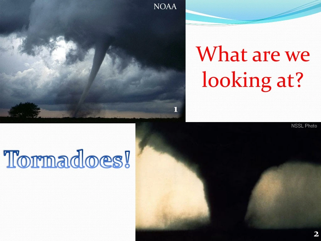
NOAA. What are we looking at?. inewscatcher.com. 1. Tornadoes!. 2. Tornadoes 20/09/2010 Learning Objectives: What conditions lead to tornadoes? In what way do they represent a hazard to people?. Tornado Definition:

E N D
NOAA What are we looking at? inewscatcher.com 1 Tornadoes! 2
Tornadoes • 20/09/2010 • Learning Objectives: • What conditions lead to tornadoes? • In what way do they represent a hazard to people?
Tornado Definition: A rotating column of air ranging in width from a few yards to more than a mile and whirling at destructively high speeds, usually accompanied by a funnel-shaped downward extension of a cumulonimbus cloud 3 4
Tornadoes can occur on nearly any landmass on Earth (except in polar regions). Tornadoes in the UK - This animation shows the location of all confirmed UK tornadoes. Click on the 2nd UK map down the page. http://www.torro.org.uk/site/index.php TORRO – the UK TORnado and storm Research Organisation
5 Regions of the world with increased likelihood of experiencing tornadoes. Source - NOAA
6 Tornado Alley Source: FEMA
Figure 2 – Tornado tracks from 1950- 2004 Courtesy of NOAA 7
US tornadoes by month Source: NOAA 8
No. of tornadoes in St Louis warning area by hour 9 Source: NOAA
Thunderstorm Formation - Animation - Click here NOAA 10 NWS For a thunderstorm to form, warm moist air is required. When cooler air arrives higher in the atmosphere, instability develops and therefore convection (warmer air rising) takes place forming a cumulonimbus cloud i.e. a thunderstorm.
Synoptic conditions required for supercell (and therefore tornado) formation NSSL 11
Link to an explanation by a US meteorologist of how a tornado can form NSSL 12
A surface low pressure system develops to the East of the Rocky Mountains NSSL 11 This causes warm, moist air to be dragged up from the Gulf of Mexico, warm/hot dry air from the desert states and cold, dry air down from the Rocky Mountains.
These three air masses converge over the Southern States (e.g. Oklahoma and Texas) and cause instability in the atmosphere to develop. NSSL 11
NOAA 10 NWS Convection occurs during the peak heating time of the day (mid-afternoon). This results in cumulonimbus clouds developing.
If the wind varies in direction and strength with increasing height (this is called wind shear), then the updraft (rising air) and downdraft (sinking air containing rain and hail) will separate. The updraft may also rotate. We now have a supercell thunderstorm. NSSL Animation of this 12
This rotating updraft is called a mesocyclone and can be seen using Doppler Radar. If these are seen then a Tornado Warning is issued for the county under the supercell thunderstorm. NSSL 12
Rainfall radar showing rainfall intensity Doppler Radar showing wind direction. Where red and green touch, winds are moving rapidly in opposite directions indicating a mesocyclone and possible tornado. 13
If warm moist air continues to flow into the mesocyclone (rotating updraft) then it can become stretched, becoming thinner and rotating more quickly (just like water down a bath plug hole). 14
The stretched mesocyclone can begin to descend to the ground. The air pressure inside it starts to fall rapidly and so water vapour cools, condenses and therefore becomes visible. A funnel cloud has formed. NSSL 15
NOAA If this continues to descend to touch the ground then we have a tornado. Wind speeds can vary from a few mph to over 300mph. Wind speeds are estimated from damage surveys and referring the Enhanced Fujita Scale (EF Scale) 1 inewscatcher.com Hail to 4inches diameter! And frequent lightning are also a threat from supercells
Cut and paste the sentences into the correct order to describe the process of tornado formation
Diagram of a classic supercell 16 Updraft Downdraft
The Enhanced Fujita Scale – Storm Prediction Center (SPC) Student activity to rate tornado based on damage photos – Click here 17
Oklahoma City May 3rd 1999 EF5 Tornado – Click Here • Oklahoma/Kansas Tornado Outbreak • May 3rd 1999 • 74 tornadoes in less than 21 hours • Four of the tornadoes were on the ground at the same time! • There was an EF5 tornado which was on the ground for 1 ½ hours and tracked 38 miles.
Oklahoma/Kansas Tornado Outbreak • May 3rd 1999 • 46 people died • 800 people injured • 8000 buildings damaged or destroyed • $1.5 billion of • damage NSSL 18 Damage near Oklahoma City on 3rd May 1999
Oklahoma Supercells NOAA 19 Storms so severe that updrafts are breaking through into the stratosphere Dryline – Border between moist and dry air and thunderstorms usually form just ahead of this.
Mind map the social, economic and environmental issues that arise during and after a tornado outbreak
Social -Deaths/injuries and associated pressure on public services -Closure of road and rail networks -Widespread power cuts -Homelessness and closure of businesses Economic -Damage to infrastructure -Damage and loss to businesses and crops -Positive for building industry
Environmental -Widespread loss of woodland -Possible contamination if any chemical storage (e.g. Farm pesticides/fertilisers) have been damaged.
Tornado prediction and the US Watch/Warning system Up to three days in advance the Storm Prediction Centre in Norman, Oklahoma issues a Convective Outlook as below. The highest risk for severe weather (tornadoes, hail >1 inch diameter and damaging wind gusts) is clearly labelled. NOAA – 20
Tornado prediction and the US Watch/Warning system If conditions remain favourable for tornadoes then a few hours before thunderstorms develop a Tornado Watch is issued detailing the threats. Local authorities can now start to put action plans into place, making public aware of the risk and this is also broadcast on local radio and TV. NOAA - 21
Tornado prediction and the US Watch/Warning system If a supercell thunderstorm forms and a mesocyclone is detected by weather radar then a tornado warning is issued. This means a tornado is imminent or already on the ground. Tornado sirens are then usually set off to inform everybody that they should seek shelter in a basement immediately. NOAA - 22 NOAA Tornado warned county
Homework – Due • Research either: • The Birmingham, UK tornado 28-07-2005 • The Greensburg, Kansas May 4th 2007 EF5 Tornado • Extension – Research in detail why the USA gets more tornadoes and why they are generally more violent than anywhere else on Earth. OR discuss the pro’s and con’s in living in a region which experiences extreme weather – should we continue building there? Tornado Siren – Click here Extreme Hailstorm– Click here Tornado Chasers – Click here
Sources: • NSSL - http://www.nssl.noaa.gov/headlines/images/dsz8.jpg • SPC - http://www.spc.noaa.gov/faq/tornado/seymour.jpg • David Hoadley - http://www.spc.noaa.gov/faq/tornado/waurikae.jpg • NSSL - http://www.spc.noaa.gov/faq/tornado/waurikaw.jpg • NOAA - http://www.ncdc.noaa.gov/img/climate/research/tornado/globdist.jpg • FEMA - http://www.fema.gov/plan/prevent/saferoom/tsfs02_torn_activity.shtm • NOAA – http://www.spc.noaa.gov/gis/svrgis/ • NOAA –http://www.ncdc.noaa.gov/oa/climate/severeweather/tornadoes.html
Sources: NOAA – http://www.ncdc.noaa.gov/oa/climate/severeweather/tornadoes.html NWS - http://www.srh.weather.gov/jetstream/tstorms/life.htm NSSL - http://www.nssl.noaa.gov/primer/tornado/images/tor_alley_lg.gif NSSL - http://www.nssl.noaa.gov/primer/tornado/images/tor_formation_lg.jpg SPC - http://www.spc.noaa.gov/faq/tornado/doppler.htm Microsoft PowerPoint ClipArt http://www.spc.noaa.gov/faq/tornado/kngsmill.jpg
Sources: NSSL - http://www.spc.noaa.gov/faq/tornado/suprcell.htm SPC - http://www.spc.noaa.gov/faq/tornado/f-scale.html NSSL - http://www.nssl.noaa.gov/news/may3rd/damage3.jpg NOAA - http://www.nssl.noaa.gov/news/may3rd/satellite.html SPC - http://www.spc.noaa.gov/products/outlook/archive/2010/day1otlk_20100519_1630.html SPC - http://www.spc.noaa.gov/products/watch/ww0190.html SPC - http://www.spc.noaa.gov/products/watch/ww0190.html