Download
1 / 18
180 likes | 356 Views
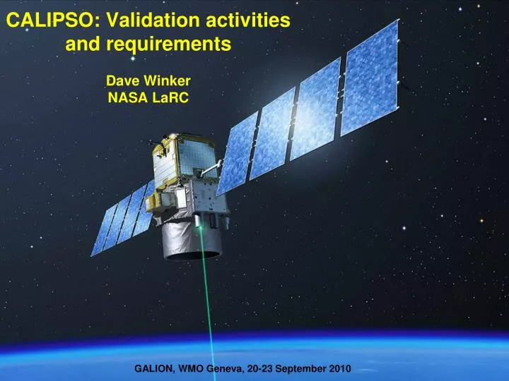
GALION, WMO Geneva, 20-23 September 2010. CALIPSO: Validation activities and requirements Dave Winker NASA LaRC. 705 km, sun-synchronous CALIOP: backscatter Nd:YAG lidar 532, 532-perp, 1064. Launch: 28 April 2006. Lidar Data Products. Level 1 (geolocated and calibrated)

E N D
GALION, WMO Geneva, 20-23 September 2010 CALIPSO: Validation activities and requirementsDave WinkerNASA LaRC
705 km, sun-synchronous CALIOP: • backscatter Nd:YAG lidar • 532, 532-perp, 1064 Launch: 28 April 2006
Lidar Data Products Level 1 (geolocated and calibrated) • DP 1.1 - profiles of attenuated lidar backscatter (532, 532^, 1064 nm) • DP 1.2 – IR radiances (8.65, 10.6, 12.05 mm) • DP 1.3 – Visible radiances (650 nm) (WFC) Level 2 • DP 2.1A – Cloud/Aerosol layer product • layer base and top heights, layer-integrated properties • DP 2.1B – Aerosol profile product • backscatter, extinction, depolarization profiles • DP 2.1C – Cloud profile product • backscatter, extinction, depolarization, ice/water content profiles • DP 2.1D – Vertical Feature mask • cloud/aerosol locations (cloud & aerosol Level 3 products in development) (available at http://eosweb.larc.nasa.gov)
Scope of CALIPSO validation • Validate instrument performance • calibration, SNR, linearity, transient recovery, etc. • Establish/verify basis for algorithm assumptions • Sa, Sc, spectral independence of cirrus backscatter, etc. • Quantify the random and bias errors in Level 2 products • identify sources of errors, if possible • instrument performance, inadequate retrieval model, retrieval assumptions, etc. • Validate the parameter uncertainties provided in Version 3 • Level 3 products • Validation of time-space averaged properties present unique challenges
Approaches to acquiring validation data • Long-term surface sites • cost is minimal • instruments well-calibrated and characterized • spatial matching requirements make sites more or less useful • can compare surface statistics with regional CALIOP statistics • But nadir-view means it takes a long time to build up statistics • Field campaigns • can provide comprehensive measurement suites required to fully understand the retrieval performance • can provide spatially and temporally matched data in any location • historically, the number of independent samples obtained is limited • field campaigns can be large and complex, or small and focused • Difficult to control large campaigns – validation is one of many objectives • Impractical – or only rare opportunities - to take campaigns to many desired locations • Other satellites • spatial matching problems with surface sites increases the attractiveness of using satellite data for validation • the A-train provides a large coincident data set from many instruments • many CALIOP measurements are unique and not available from other satellites • Passive satellites more useful as ‘sanity checks’ than true validation
CALIOP Validation Needs (1/2) • All data for validation use must be accompanied by error bars • 532 nm calibration • Need to assess latitudinal dependence • Currently based on HSRL comparisons: 10N – 70N, no SH data • Accurate assessment (< 5%) from G/B lidar possible? • 1064 nm calibration • Accurate 1064 calibration difficult for all lidars (?) • Currently, relying on comparisons with 532 nm returns from clouds and ocean surface to assess 1064 calibration • Aerosols • Detection sensitivity fairly well established, is sometimes useful to quantify what is missed (eg: Arctic) • Extinction profiles and AOD • And …. continued:
CALIOP Validation Needs (2/2) • The things that AOD and extinction depend on: • Calibration • Cloud-Aerosol Discrimination • Correct classification of aerosol type • Lidar ratio • LaRC HSRL provides 532 nm lidar ratios over US/Canada • Must be supplemented by G/B measurements for additional spatial/temporal coverage • Need better information on 1064 nm lidar ratios • Multiple scattering corrections • Etc. • Uncertainty parameters included in Version 3 • primarily for extinction and AOD • Monthly gridded data (Level 3) • G/B network measurements required to validate Level 3 products, especially profiles • Aircraft data too limited in space/time • Other satellites do not provide profiles
Validation from LaRC HSRL • A key resource for CALIOP validation: • Aerosol backscatter and depolarization at 532 nm and 1064 nm • Aerosol extinction via HSRL technique at 532 nm • Flies on NASA-LaRC King Air • 2006-2010: >100 CALIPSO underflights
Validation of Level 1 profiles w/ LaRC HSRL HSRL CALIPSO C532 = 6.34478e10 C1064 = 8.0892e9 = -2% = 1% 532 nm 1064 nm
HSRL comparisons used to assess CALIOP 532 nm calibration Comparison uncertainty ~ 4-5% Mean night bias = 4.91 % Mean daytime bias = 4.4 %
HSRL measurements of Sa Oklahoma (CHAPS) Typical range of Sa for continental aerosol? Maryland (CATZ)
Sa comparisons from most recent campaign From co-located HSRL-CALIOP measurements (HSRL observations partitioned according to CALIOP aerosol typing) “polluted dust” marine dust smoke August 2010 campaign:
What are we missing? (Eureka HSRL, 82° N) 10-5 10-4 10-3 10-2 Backscatter (km-1sr-1) Eureka HSRL Sept. 9, 2010 jason.l.tackett@nasa.gov 14
Tropical Cirrus: Nauru ARM lidar Thorsen, Fu, & Comstock (ASR STM 2010)
L+18 L+36 L - 8 ~L+7 months months days months ~L+45 days w.r.t. EarthCARE: CALIPSO Timeline Pre-Launch Activities Platform Checkout Payload Checkout Science Operations Launch Assessment LEOP Activities Validation Level 1 & 2a Level 2b L+135 days L=0 Version 1.0 data release preliminary data release
Long-term aerosol climate data • Bridging from CALIPSO to EarthCARE and beyond not trivial • Especially if there is no on-orbit overlap • CALIOP: 532, 532-perp, 1064 • ATLID: 355, 355-perp, Sa • Spectral aerosol b, s, Sa need to be characterized (globally) • Instrument designs will also result in differences in: • cloud-aerosol discrimination • aerosol type identification • Long-term, widespread groundbased lidar networks required
Validation lessons-learned • Calibration via molecular normalization requires validation • Validation of CALIOP is greatly complicated by sampling issues related to the “zero swath” • space/time matched observations are necessary to eliminate questions due to matching errors • different degrees of inhomogeneity for aerosols and clouds result in different validation strategies • Thorough validation in one region ≠ global validation • Validation in many different regions is required • Dedicated aircraft campaigns (LaRC HSRL, CC-VEX) are much more flexible, and can be more productive than large field campaigns • Difficult to make use of in situ measurements due to limited sampling – but can provide critical information not available by other means • Validation is never finished • The need for validation continues after completion of funded field campaigns