Download
1 / 20
200 likes | 327 Views
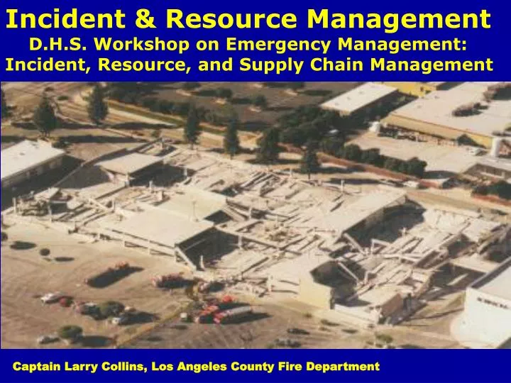
Incident & Resource Management D.H.S. Workshop on Emergency Management: Incident, Resource, and Supply Chain Management. Captain Larry Collins, Los Angeles County Fire Department. The ShakeOut Earthquake Scenario—A Story That Southern Californians Are Writing.

E N D
Incident & Resource Management D.H.S. Workshop on Emergency Management: Incident, Resource, and Supply Chain Management Captain Larry Collins, Los Angeles County Fire Department
The ShakeOut Earthquake Scenario—A Story That Southern Californians Are Writing By Suzanne Perry, Dale Cox, Lucile Jones, Richard Bernknopf, James Goltz, Kenneth Hudnut, Dennis Mileti, Daniel Ponti, Keith Porter, Michael Reichle, Hope Seligson, Kimberley Shoaf, Jerry Treiman, and Anne Wein Circular 1324 Jointly published as California Geological Survey Special Report 207 U.S. Department of the Interior U.S. Geological Survey
“What If” Became the Largest Earthquake Exercise in U.S. History (Over 5 Million People in 2008, Nearly 7 Million in 2009)
7.8 (2009)Shakeout 2009 Tabletop Booklet L.A. County Fire Department October 15, 16, and 18, 2009
A Predictable Future Catastrophe: 7.8 San Andreas Fault Earthquake
Bridging the Gap Between Science And Emergency Responders
Mud & Debris Flows: Planning & Emergency Response Considerations
Tragedy Begets Tragedy: The Station Fire (July/August 2009)
New Years Day Flood, 1934: More Than 100 Dead (Some Never Found)
Wednesday, Oct. 7, 2009 The U.S. Geological Survey today issued a grim forecast for foothill communities hit by the Station fire, saying huge mudslides and debris flows are highly likely during the winter rainy season. Scientists have been spending the last few weeks studying terrain destroyed by the largest fire in Los Angeles County history to determine which areas have the greatest risk of mudslides. They identified Pacoima Canyon, Big Tujunga Canyon, the Arroyo Seco, the West Fork of the San Gabriel River and Devils Canyon as being 80% likely to experience flows of up to 100,000 cubic yards of debris, enough cover a football field with mud and rock to about 60 feet deep. “Some of the areas burned by the Station fire show the highest likelihood for big debris flows that I’ve ever seen,” said Susan Cannon, a USGS research geologist and one of the authors of the emergency assessment. Cannon has been studying debris flows after fires for 11 years. “We don’t have the science to model where it will travel, but there’s a really good chance of a big debris flow happening within that drainage system," she added.
Station Fire, 2009 -160,000 + Acres In Some of the Highest- Producing Mud & Debris Flow Terrain in N. America < Pickens Canyon Fire, 1933 (7,000 Acres) 2009 Station Fire Burn Area (Solid Black Line) 1933 Fire (LaCrescenta) Burn Area (Shaded)
Trigger Points To Initiate Evacuations: -Burn Areas -Anticipated Rainfall -Saturation Levels -Mud & Debris Flow Pre-Attack Plans For Individual Threatened Areas -Actual Mud & Debris Flows -Damage to Flood Control