Download
1 / 15
150 likes | 238 Views
SERVIR MODIS and OSM. Acquisition Data Analysis, Processing, Serving. Acquisition. Data Creation Point, Line, Polygon, Linear Polygon Feature Class Determination (Shoreline v. Island) Attribute Fields and Data Types (Google Example Centralized System

E N D
SERVIRMODIS and OSM Acquisition Data Analysis, Processing, Serving
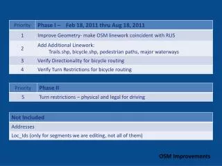
Acquisition • Data Creation • Point, Line, Polygon, Linear Polygon • Feature Class Determination (Shoreline v. Island) • Attribute Fields and Data Types (Google Example • Centralized System • Take the tools and implement into one system • SDP Toolkit,
Acquisition, Serving, Processing MODIS WIST, LPDAAC, NASA catalog ArcServer and Envi – HDF EOS/4/5 Algorithm to GeoTiff HEW Subsetting SDP Toolkit RBDMS – ARCSDE and Raster Catalog Routine for Imagery Extraction HEG - HDF to Geotiff Imagery Extension Reprojection on the fly
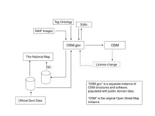
Acquisition, Serving, ProcessingOSM • Sources • Planet OSM • Cloud Made • Comparison Datasets • Google Earth, Virtual Earth, Military • National Datasets • Needs • Usable attribution – Geodatabase dropdowns • 2D and 3D datasets • Terrain Dataset (soils, slope) • Regional Collaboration for Roads Surveys Standards
Spatial Data Management Scheme (1) • SDI, ISO 19133 and TransXML (in process) • Current International Standards Analysis • OGC/Model Identification – Short and Long-term Needs • Hierarchical Attribution and Symbology Standard • Spatial Capabilities / Raw Data Functionality • Network and Volume/Flow Analysis • Viewshed and Least cost path analysis • Routing and Statistics • Economic Development/Political • Supporting Infrastructure • Probability Hazards Mapping and Emergency Response • Modal Transfer Points (Planes, Trains, and Automobiles)
Spatial Data Management Scheme (2) • ArcSDE Geodatabase(s) • Translation into the SERVIR schema • XML/GML cooperative • Editing, Validation/Verification • Comparison Matrix • Updating and Resubmission to OSM • Example SANGIS Schema
Issues • Issues • Error (User/Interface/Methodology/Standards) • Missing Data and/or Attributes (Example) • Duplicate Data (Example) • Topology and Geometric Shapes (Example) • Aggregation (Example) • National Level Datasets Projections • International Geocoding Diversity • Languages Utilized and Displayed (Example) • Legends and Data Investigation
Development Environments and Technologies (1) • ArcSDE Geodatabase • Geoprocessing tasks • Out of the box • Toolshare • Model Builder • Scripting/OGC/Javascript API • Open Layer Jquery (pop-ups, document management delivery) • ArcServer Capabilities • Simultaneous Editing and Automated Validation/Verification • Identification of Data in Web Applications v. WMS • Spatial and Statistical Tools and Analysis • Conversions and Exports >>> arcpy.AddField_management("c:/data/Portland.gdb/streets", "LENGTH_MILES", "TEXT") >>> arcpy.CalculateField_management("c:/data/Portland.gdb/streets", "LENGTH_MILES", "!shape.length@miles!",
Performance and Sustainability • Guidelines • If it doesn’t work, no one will use it! • If it is difficult to use or lengthy instructions, no one will use it! • If the functionality is weak, no one will use it! • Design Responsibilities • Maximum use of progressive technology and scripting effectively • Algorithm and Work Flow identification • Parallel Processing • Expandability and Network Links/WMS/WFS • Testing • Capabilities • CONTENT and CONTEXT – “Purpose and Message” • Thin Client • Speed • Individual Investigation – DSS for cross/multiple disciplinary knowledge workers • Data Interoperability
Development Environments and Technologies (2) • ArcServer and Server Technologies • FLEX, Silverlight, and Sharepoint - API libraries and templates • 3D Explorers (ArcExplorer, GeoPDF, NASA Worldwind(Flex), AGI SDK) • Unlimited Extensible Possibilities (GeoPDF, Google Earth and Embedded Maps) • Multiple Import/Export Data Sharing Methods (KML, XML) • API’s (Embedding, Routing, Geocoding) • Open Layers + Query • Issue – Need for keys for user in some cases • User Interface Language Control • Mobile GIS • Web-based digitizing • Internet GIS (ArcServer, Flex, Services) • Google Imports • Geographic PDF Comment and Markup (Adobe Reader) • Smart Phones
Cartography • Demonstration • Symbology • Coverages • WMS Imports and Sharing • Principles • Products • Illustrator Maps • Geographic PDF’s
Data Tables and Data Types • Classification and Symbology – Spatial DSS – Network Analysis and Statistics
Approach • Investigate and Drill Data • Analyze Data Creation Methods and Standards • Current for needed products • In conjunction with Short and Long-term goals • User Needs Analysis and Skill Set Accommodations • Systematic Algorithm (Input to End User) • System Architecture and Interoperability