Download
1 / 25
260 likes | 629 Views
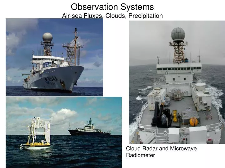
Observation Systems Air-sea Fluxes, Clouds, Precipitation. Cloud Radar and Microwave Radiometer. NOAA Ship Ronald H. Brown. NOAA Ship Ronald H. Brown. Ron Brown Mast. NOAA/ESRL Turbulent Flux System. TeraScan visible image with Stratus Buoy (NOAA-18, 20:43 UTC 10/19/2006)

E N D
Observation SystemsAir-sea Fluxes, Clouds, Precipitation Cloud Radar and Microwave Radiometer
TeraScan visible image with Stratus Buoy (NOAA-18, 20:43 UTC 10/19/2006) GOES, NOAA, DMSP, SeaWiFS, Aqua, etc
Radiometrics Model 1500 22-30 GHz Continuous water vapor profiles up to 10km, integrated liquid water. NOAA ESRL also has a Model WVR-1100 (mailbox)
ILW IR PWV Shortwave
NOAA ESRL Ship ObservationsTAO/PACS and Stratus • Fall 2001, 2003-07 (6 years) 20˚S, 75-85˚W (Stratus). 2001, 2003-04, ±10˚N, 95˚ and 110˚W (TAO/PACS). • Observe: • Surface meteorology • Turbulent and radiative fluxes • Cloud vertical structure: top, base, and LCL. • Rawinsonde profiles • Column water vapor and liquid water path • Aerosols
Cruise Tracks PACS: Spring 2000-02 Fall 1999 - 2004 STRATUS 2001, 2003-07
GFDL CM2.1 IROAM TAO/PACS Heat Fluxes95 & 110˚W 0 0 -40 -40 latent -80 -80 -120 -120 -160 -160 -12 -8 -4 0 4 8 12 -12 -8 -4 0 4 8 12 0 0 sensible -10 -10 -20 -20 -12 -8 -4 0 4 8 12 -12 -8 -4 0 4 8 12 Model TAO buoy WHOI (1984-2002) [Yu and Weller 2007] CORE (1984-2004) [Large and Yeager 2004] NOAA ship observations(1999-2002) [Fairall et al. 2008] 0 0 -25 -25 longwave -50 -50 -75 -75 -12 -8 -4 0 4 8 12 -12 -8 -4 0 4 8 12 300 300 250 250 solar 200 200 150 150 100 100 -12 -8 -4 0 4 8 12 -12 -8 -4 0 4 8 12 200 200 150 150 100 100 net 50 50 0 0 -50 -50 -100 -100 -12 -8 -4 0 4 8 12 -12 -8 -4 0 4 8 12 north latitude
Potential temperature, humidity, and cloud vertical-longitude section
Liquid and vapor water column diurnal sampling
2 6 cloud top 6 5 6 1.5 7 4 6 3 7 3 3 5 3 1 5 7 3 6 5 6 6 7 3 4 5 7 3 1 4 4 6 5 4 3 5 4 height (km) 1 1 3 1 7 7 1 1 1 4 cloud base 3 4 6 6 5 1 1 4 5 1 7 7 4 6 3 6 4 7 1 1 5 6 1 6 1 6 3 7 5 7 7 5 5 5 7 4 7 4 1 3 4 0.5 surface LCL 3 4 3 0 -85 -82.5 -80 -77.5 -75 degrees longitude Cloud height diurnal sampling 0 0 0 0 0 250 25 25 25 50 18 6 18 6 18 6 18 6 18 6 12 12 12 12 12
Effect of stratification and mixing on cloud base Cloud base above 900 m decoupled from surface layer cloud base 10% higher than LCL
FY2009 Ron Brown Strawman – Subject to change DAS Port Stratus (20S, 85W) Charleston – Arica 53 6 TAO/PACS (95W – 110W, 12N – 12S) Arica – Charleston 41 6 [23 week drydock] Western Boundary Current Charleston – San Juan 21 3 NTAS / MOVE / NWS (45W, 16N) San Juan – Barbados 15 3 Pirata (38W – 8E, 21N – 19S) Barbados – Charleston 33 3 Total for FY2009 160 20
FY2010 Ron Brown Strawman – Subject to change DAS Port Stratus (20S, 85W) Puenta Arenas – Arica 29 3 TAO/PACS (95W – 110W, 12N – 12S) Arica – Miami 41 6 [10 week drydock] Western Boundary Current Miami – San Juan 21 3 NTAS / MOVE / NWS (45W, 16N) San Juan – Barbados 16 7 Pirata (38W – 8E, 21N – 19S) Barbados – Miami 33 3 Deep Corals (GOM) Miami – Panama 28 3 CalNex (Southern California) Panama – San Diego 46 5 Vents (East Pacific Rise) San Diego – San Diego 18 3 Total for FY2010 236 29
NOAA/ESRL operates and maintains a number of systems on the RHB • Turbulent and radiative fluxes • Microwave radiometer and ceilometer • Cloud, wind, and precipitation radars • Radiosondes • Occasional co-deployment with lidar systems • NOAA/ESRL plans numerous deployments the next 3-5 years • Deployments depend upon funding (e.g., radiosondes) • Other ships are used (UNOLS, Ka’imimoana, USCG ice breakers, etc)