Download
1 / 15
150 likes | 499 Views
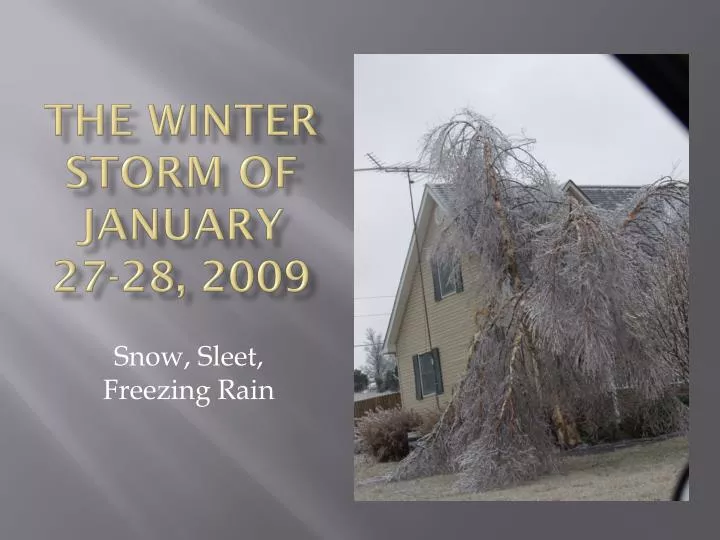
The Winter storm of January 27-28, 2009. Snow, Sleet, Freezing Rain. A Short Introduction to Cloud Physics. To make snow, the temperature must be below freezing the entire path until at the surface.

E N D
The Winter storm of January 27-28, 2009 Snow, Sleet, Freezing Rain
A Short Introduction to Cloud Physics • To make snow, the temperature must be below freezing the entire path until at the surface. • Once snow melts as it is falling, it will not turn back into snow again, no matter the temperature. • Melted snow that drops below freezing will stay liquid, called "supercooled". This is freezing rain. • If freezing rain completely refreezes, it will become sleet.
January 27 After Midnight SNOW T < 32 °F
January 27 Early Morning SNOW T < 32 °F RAIN T > 32 °F SLEET T < 32 °F
January 27 Mid Morning SNOW T < 32 °F RAIN T > 32 °F T < 32 °F FREEZING RAIN
Sounding at 2:38PM 5 °C (40 °F) at 6000 ft -5 °C (23 °F) at 1000 ft
Sounding at 7:11PM 7 °C (44 °F) at 3000 ft -4 °C (25 °F) at 1500 ft
January 28 Early Morning SNOW T < 32 °F RAIN T > 32 °F
January 28 Mid Morning SNOW T < 32 °F
What We Did • Tuesday January 20th (7 days in advance) • Outlook: Large winter system will affect area on Monday and Tuesday. • Forecast Tuesday: 50% chance of snow. • Wednesday January 21st • Outlook: Significant weather system will impact area early next week...accumulations of snow, sleet, and freezing rain late Monday Night and Tuesday. • Forecast Tuesday: 60% chance of light snow. Light snow accumulations. • Thursday January 22nd • Outlook: Storm system will impact area late Monday and Tuesday...wintery mix • Forecast Tuesday: 60% chance of light snow. Light snow accumulations.
What We Did (con't) • Friday January 23rd • Outlook: Storm system will likely spread wintery precipitation Late Monday through Early Wednesday...significant accumulations possible. • Forecast Monday Night & Tuesday: 60% chance of snow. significant snow accumulations possible. • Saturday January 24th • Outlook: Big winter storm will impact area Late Monday through Wednesday...significant snow and ice accumulation are expected Late Monday Night through Tuesday Night. • Forecast Tuesday: 70% chance of snow and slight chance of sleet. Light snow accumulations. • Sunday January 25th • Preliminary Conference Call • Winter Storm Watch: Two waves...first wave, 3 to 6 inches of snow...second wave, quarter inch of ice. • Forecast • Monday Night: 3 to 6 inches of snow. • Tuesday & Tuesday Night: Freezing rain, sleet & snow.
What We Did (con't) • Monday January 26th • Conference Calls • Winter Storm Warning: Snow, sleet, and ice...3 to 4 inches of snow by Tuesday Morning with an additional 1 to 2 inches of snow and sleet Tuesday Night. • Forecast • Monday Night: 3 to 5 inches of snow. • Tuesday: Sleet and snow until midday then sleet, freezing rain and snow in the afternoon. Snow and sleet accumulation of 1 to 2 inches...tenth of an inch ice. • Tuesday Night: Freezing rain and sleet in the evening, snow after midnight. Snow and sleet accumulation of 1 to 2 inches...quarter of an inch of ice.