Download
1 / 21
210 likes | 689 Views
Fate and Transport of Petroleum Hydrocarbons Released into the Lower Mississippi River, Diversions, and Adjacent Coastal Wetlands. Samantha Danchuk ...

E N D
Fate and Transport of Petroleum Hydrocarbons Released into the Lower Mississippi River, Diversions, and Adjacent Coastal Wetlands Samantha Danchuk Department of Civil & Environmental Engineering Louisiana State University
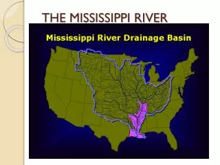
Lower Mississippi River Delta Delta Composition: • MS River: Baton Rouge to Head of Passes (~228 river mi) • Fresh Water Diversions in LMRD • Wetlands (7th largest, 30% US coastal marsh) Resources: • Drinking water source (1.5 million residents, 30% LA) • Natural Resources: Fisheries ($290 million/yr) • Outdoor Recreation ($790 million/yr) • Wildlife Habitat • Inland Surge Protection Source: Lower Mississippi River Conservation Committee (2004), DEQ
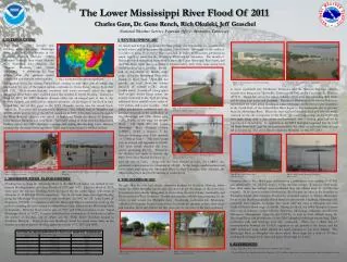
Refineries, Tankers, Pipelines Clovelly Port Fourchon • Louisiana’s wetlands are the most industrialized in the world, providing oil resources in the form of wells and production facilities throughout the marshes and bayous. Refinery Locations
Oil Transport in LA • Supertankers deliver crude oil to the deepwater port in Gulf of Mexico, Louisiana Offshore Oil Port (LOOP) (1.2 million barrels/day) LOOP • Oil from storage and onshore/ offshore wells is shipped and piped to refineries (18 in Louisiana) Supertankers • Pipelines pump oil onshore to the Fourchon Booster station and then to the Clovelly Dome Storage Terminal, where oil is stored in underground salt domes (cap. 40 million barrels) Salt Dome Storage Booster Station Pipeline Crossings Refinery Oil/ Gas Wells
Accidental Hydrocarbon Releases • Now that you see how much oil comes across the state, recognize the risk for accidents and oil spills • Oil spills occur at loading/ unloading sites, tanker leaks, pipeline breaks, pipelines pushed to surface and snapped and during catastrophic events i.e. hurricanes, storm surge • What happens to the oil once released into the river? Diversion? Wetlands? • Address issue of spilled oil being “unaccounted” for during cleanup (90,000 barrels after Katrina)
Project Outline Couple
Hydrodynamic Model • Before building an oil fate & transport model, must describe hydraulic flow in the river, diversions, and through wetlands • Governing Equations: • Reynolds Averaged Navier Stokes Momentum Eqns • Conservation of Mass • Turbulence Closure Model • Data Requirements: Boundary Conditions, velocities, water surface elevations, bathymetry • Sources: USACE, USGS
ADaptive Hydraulics Modeling (ADH) • State of the art in hydrodynamic modeling • Developed by the Coastal and Hydraulics Laboratory, ERDC, USACE • Models 2D or 3D N.S. flow, shallow water flow, groundwater, wetting/ drying, sediment transport, wind impact • Adaptive numerical meshes improve model accuracy without sacrificing efficiency • Allows for rapid convergence of flows to steady state solutions • Runs in parallel, on a single processor, Windows & UNIX • Finite Element 2D Shallow Water Equations • Galerkin Least Squares Methods (linear interpolation eliminates Finite Element dispersion error) Navier Stokes
ADH: Adaption • Mesh intelligently adapts so high resolution requirements are met in certain areas • Grid resolution matches differential equations • 3D- Tetrahedral elements • 2D- Triangles • Saves computational time 1 2 3 Source: ADH, Coastal Hydraulics Lab, ERDC
Wetland Hydrodynamics • Focus on the physics of flow across low sloping wetlands • Local characteristics: roughness, permeability, water level fluctuation, water chemistry, large variability across area, vegetation, roughness • Iterative process for different geometries based on different hydraulic inputs • River Hydraulics well documented, • Oil spills in rivers mostly understood, • Oil spills across wetlands new research
Oil Transport Modeling • Solute & Immiscible Compound Transport • Floating Surface Layer & Mixed Water Column • Processes & Parameters: Advection, Dispersion, Diffusion, Volatilization, Biodegradation, Continuous exchange between layers, Sorption, Density changes, shoreline conditions, flow/ water level changes, vegetation filtration, sedimentation • Potential Data Sources: DEQ’s Early Warning Detection System, Available Spill Data, Aerial Photographs/ Remote sensing delineating spill
Focus • Louisiana is a hot spot for oil transport; potential risk for oil spills is a significant concern • How would an oil spill move downstream in the lower Mississippi River? What if a diversion is open and the wetlands are contaminated? • What zones are at the most risk? What can we learn to improve our emergency preparedness? • Investigate the complex CFD problem of modeling two- phase flow through different hydraulic environments and varying conditions • Petroleum transport greatly impacts the public and the natural coastal environment, the science and knowledge of each field must collaborate to improve the current approach
Interdisciplinary Approach Physical Transport ADH Solute Lagrangian Particle Algorithm Chemical Degradation Immiscible Compounds Visualization Physics ASCE CHL Public Health Water Chemistry Oil Industry Environment Conservation
Advisory Committee • Dr. Clint Willson Department of Civil & Environmental Engineering • Dr. Chunyan Li Department of Oceanography & Coastal Sciences • Dr. Zhi-Qiang Deng Department of Civil & Environmental Engineering
References • www.eia.doe.gov • http://www.dotd.state.la.us/programs_grants/loop/loop.shtml • www.fotojinak.info/index%206.htm • http://chl.erdc.usace.army.mil • http://www.osradp.lsu.edu/guidelines.htm • cryptome.quintessenz.at/mirror/loop-eyeball.htm • http://gulfsci.usgs.gov/missriv/aerials.html • lagic.lsu.edu/.../wepgeog3dxdnr_faq.html
Interdisciplinary, Collaborative Efforts • Coursework has been divided between • “Traditional” Civil and Coastal Engineering • Oceanography and Coastal Sciences • Computational Fluid Dynamics • Initial funding was from the LA Department of Natural Resources project, “Small-Scale Physical Model (SSPM) of the lower Mississippi River Delta • Part of a team of graduate students working on physical and numerical modeling of flow and sediment
Lower Mississippi River Delta • Barataria Bay has been designated an estuary of national significance by the Environmental Protection Agency National Estuary Program. • The bay is characterized by swamp forests and marshes which provide a nursery and breeding ground for migratory birds and a variety of recreationally and commercial important species.
Interdisciplinary, Collaborative Efforts • Challenges • Simulate the hydrodynamics in the lower Mississippi River • Simulation the hydrodynamics in the wetlands and estuary system • Microtopography • Roughness • Tidal influences • Simulate and couple the physics of oily transport
Estuarine-coastal Hydrodynamics Teaching Activities OCS 7123 - Oceanographic Data Analysis OCS 4170 - Physical Oceanography XD-1 - Multi Scale Fluid Dynamics (IGERT class) (PO module) OCS 7125 - Estuarine Dynamics
Research Activities observations