Download
1 / 20
200 likes | 455 Views
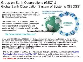
Overview of USGEO and Canadian GEO Collaboration. Peter E. Colohan United States Group on Earth Observations April 21,2010. What is GEO?

E N D
Overview of USGEO and Canadian GEO Collaboration Peter E. Colohan United States Group on Earth ObservationsApril 21,2010
What is GEO? • The intergovernmental Group on Earth Observations (GEO) is a voluntary partnership of 80 Member governments and the European Commission, working with 58 Participating Organizations • GEO is coordinating efforts to build a Global Earth Observation System of Systems, or GEOSS • A forum to develop new projects, coordinate strategies and investments What is GEOSS? • A distributed system of systems • Improves coordination of strategies & observation systems • Links all platforms: in situ, aircraft, & satellite networks • Identifies gaps in our global capacity • Facilitates exchange of data & information • Improves decision-makers’ abilities to address pressing policy issues
2010 GEO Ministerial SummitBeijing – 5 November 2010 Main focal points: • The mid-term assessment of progress on the GEOSS 10-year Implementation Plan (2010-2015) • Sustaining an operational GCI • Endorsing actions in support of the GEOSS Data Sharing Principles • Renewed commitments to observing systems, especially in situ systems • Laying the framework for the implementation of the GEOSS in the period 2010-2015 (and beyond).
Established to coordinate Canada’s response & engagement in international GEO & to meet Canadian Earth observation challenges • Environment Canada led (GEO Principal for Canada) • Member departments & agencies: Agriculture, Canadian Space Agency, Fisheries & Oceans, Foreign Affairs, National Defence, Health, Natural Resources, Parks Canada, Public Safety, Statistics Canada • Governance • CGEO ADM Steering Committee (SC) • CGEO DG-level Interdepartmental Coordination Committee (ICC) • Interdepartmental Secretariat established 2005 • Advance the coordination of EO within Canada • Develop a ‘Federal Earth Observation Strategy’ • Identify and facilitate collaborative EO projects and development of a Canadian GEOSS • Advocate & catalyze coordinated, comprehensive and sustained EO • Establish partnerships for implementing EO tasks and activities • Manage Canada’s involvement in International GEO • Maintain close relations with international GEO Secretariat (Geneva) • Prepare Canada’s positions in GEO Plenary Meetings & Ministerial Summits • Establish strong ties with key countries, especially USA • Co-chair GEO Americas Caucus and GEOSS in the Americas initiatives • Support GEO processes and GEOSS development
Steering Committee (Assistant Deputy Minister level) GEO Principal for Canada (Environment Canada – lead Department) Interdepartmental Coordinating Committee (Director General level) Working Groups CGEO Secretariat (hosted by Environment Canada – funded interdepartmentally) International Team other Task Teams CGEO Governance
U.S. Group on Earth Observations • Established in March 2005 as a standing subcommittee of the National Science and Technology Council Committee on Environment and Natural Resources • Develops the U.S. Integrated Earth Observation System • Advances international coordination by formulating U.S. positions and inputs to GEOSS, taking into account the requirements of the widest range of decision-makers, researchers, service-providers, the public and other stakeholders
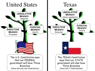
National Science and Technology Council Committee on Environment and Natural Resources 25 Federal agencies and agency components in the U.S. Federal Structure The White House/Executive Office of the President
USGEO Interagency Coordination Strategic Assessment Recently, the U.S. has expanded existing evaluation and assessment methodologies to better understand the costs and benefits of closing identified gaps in Earth observing capabilities and to prioritize future investment opportunities based on this framework. This strategic assessment will further develop the U.S. Integrated Earth Observation System (IEOS), which harmonizes Federal government investments in Earth observations and comprises the U.S. National contribution to GEOSS. Assessment Goals Provide an integrated picture of national Earth observations priorities Maximize Federal investment in Earth observations Focus near-term decision-making at the highest levels of government Consider measurements from all types of platforms: space-based, airborne, subterranean, land and sea-based Address continuity of current measurements as well as the need for new measurements
USGEO-CGEO Collaboration Vision • Begin conceiving of North America as a single geographic space for the purpose of Earth observation, particularly along the world’s longest uncontested international boundary.
USGEO-CGEO Collaboration Three general purposes: • Coordinate engagement in GEO; • Coordinate cooperation on GEOSS in the Americas; • Encourage specific technical cooperation initiatives between the U.S. and Canada on Earth observations.
USGEO-CGEO Collaboration Water and Ice Workshop - Oct 2008 • Hosted by the U.S. National Science Foundation in Arlington, Virginia (US); • Engaged over 80 US and Canadian experts; • Produced 13 recommendations for improving cryospheric and hydrologic Earth observations from a trans-boundary perspective.
USGEO-CGEO Collaboration • Toronto Meetings – May 2009 • Hosted by CGEO, involving 30 experts and leaders from the U.S. and Canada; • Focused on five areas of specific cooperation building on the recommendations of the Water and Ice Workshop.
USGEO-CGEO Collaboration • Five Projects– May 2009 • Develop three international, interdisciplinary water-related monitoring testbeds, building on existing initiatives, along the U.S.-Canada border; • Initiate two studies of drought in the context of hazards and extreme events.
USGEO-CGEO Collaboration Great Lakes Testbed • Given the long-standing mandate for joint monitoring since the 1987 Great Lakes Water Quality Agreement, the vast amount of data available from this region, and the many existing cooperative programs along the Great Lakes, the goal of this testbed activity is to bring together the many initiatives to facilitate coordination both on water availability and water quality monitoring.
USGEO-CGEO Collaboration Prairies Region Testbed • Interest in the Prairies stems from the need to close gaps in critical Earth observation requirements for agriculture, specifically soil moisture. Greater, more concerted efforts are required both in soil moisture data collection as well as soil moisture modeling, particularly the effects on plant stress and root stress. Flooding extremes could also be examined in these contexts.
USGEO-CGEO Collaboration Rocky Mountains Testbed • This region was identified because of its role as a laboratory for cold-water processes, as well its importance as the source of many trans-boundary river systems, including the Saskatchewan, Missouri and the Columbia and it’s implications for the Colorado and Athabasca systems.
USGEO-CGEO Collaboration Surface Water Supply Index (SWSI) Study • The goal of this effort is to explore expanding the availability and use of SWSI, a popular index for drought management in the Western U.S., noting the growing demand among users for this index at greater frequency and resolution. The study will examine how SWSI can be further refined and tested, including in Western regions of Canada.
USGEO-CGEO Collaboration Drought Definitions and Indices Study • This study examines the need to improve the definition of drought for different climatic regions, and the need to develop new and improved indices for drought, including vegetation. Continent-wide study is needed for comparative analysis across regions, and close links to the testbed activities will be pursued to refine definitions and indices for specific regions.
www.earthobservations.org For More Information usgeo.gov www.cgeo.gc.ca