Download
1 / 22
250 likes | 505 Views
Introduction to Geographic Information Systems (GIS) Lesson 1. Amriddin Samiev, Ph.D. TSPU, Hungary 2012. Outlines. Introduction Who use GIS? & what can we do with GIS How does GIS work? Geography database & types of data Features of GIS SDI summary. We Live in Two Worlds.

E N D
Introduction to Geographic Information Systems (GIS)Lesson 1. Amriddin Samiev, Ph.D. TSPU, Hungary 2012
Outlines • Introduction • Who use GIS? & what can we do with GIS • How does GIS work? • Geography database & types of data • Features of GIS • SDI • summary
We Live in Two Worlds Natural World Constructed World Managed Self-Regulating . . . These Are Increasingly In Conflict
Watersheds Communities Neighborhoods Districts Patterns Linkages Trends Managing Places Seeing the Whole Context and Content
Geographic Information System (GIS) is a computer-based system including software, hardware, people, and geographic information • A GIS can: • create, edit, query, analyze, and display map information on the computer
Geographic Information System • Geographic – 80% of government data collected is associated with some location in space • Information- attributes, or thecharacteristics (data), can be used to symbolize and provide further insight into a given location • System – a seamless operation linking the information to the geography – which requires hardware, networks, software, data, and operational procedures …not just software! …not just for making maps!
Who uses GIS? • International organizations • UN HABITAT, The World Bank, UNEP, FAO, WHO, etc. • Private industry • Transport, Real Estate, Insurance, etc. • Government • Ministries of Environment, Housing, Agriculture, etc. • Local Authorities, Cities, Municipalities, etc. • Provincial Agencies for Planning, Parks, Transportation, etc. • Non-profit organizations/NGO’s • World Resources Institute, ICMA, etc. • Academic and Research Institutions • Smithsonian Institution, CIESIN, etc.
What can you do with a GIS? • The possibilities are unlimited… • Environmental impact assessment • Resource management • Land use planning • Tax Mapping • Water and Sanitation Mapping • Transportation routing • and more ...
How does a GIS work? • GIS data has a spatial/geographic reference • This might be a reference that describes a feature on the earth using: • a latitude & longitude • a national coordinate system • an address • a district • a wetland identifier • a road name
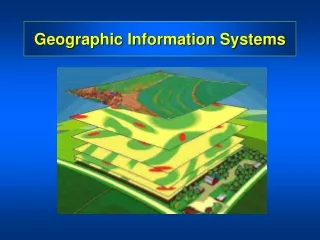
Very high 3 Scrub 17 Clay Polygon Geography and Databases • A GIS stores information about the world as a collection of thematic layers that can be linked together by geography
107’ Vectors Dimensions Topology Surveys ABC Networks Images Annotation CAD Drawings 27 Main St. 3D Objects Attributes Addresses Terrain GIS provides Data Integration • Roads • Land Parcels • Population • Utilities • Land Mines • Hospitals • Refugee Camps • Wells • Sanitation
Two fundamental types of data • Vector • A series of x,y coordinates • For discrete data represented as points, lines, polygons • Raster • Grid and cells • For continuous data such as elevation, slope, surfaces • A Desktop GIS should be able to handle both types of data effectively!
Data Representation Raster Vector Real World
Other features of a GIS • Produce good cartographic products (translation = maps) • Generate and maintain metadata • Use and share geoprocessing models • Managing data in a geodatabase using data models for each sector
Hint – having GIS software does not a cartographer make! • Good to know something about these issues when creating a map and doing spatial analysis… • Scale/Resolution • Projection • Basic cartographic principles regarding design, generalization, etc.
Spatial Data Infrastructure(SDI) • Definition - the technology, policies, standards, human resources, and related activities necessary to acquire, process, distribute, use, maintain, and preserve spatial data • Part of many nation’s e-Gov strategy • www.GSDI.org
Citizens Inventory Geographic Knowledge The World Decision Support
World Summit on Sustainable Development 2002 “Promote the development and wider use of earth observation technologies, including satellite remote sensing, global mapping and geographic information systems, to collect quality data on environmental impacts, land use and land use changes.”
Achieving the MDGs requires all of us… …working together!