Download

1 / 61
620 likes | 1.17k Views
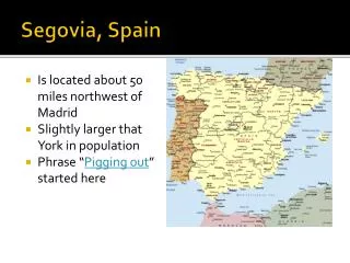
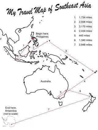
What is the approximate distance from Paris, France, to Madrid, Spain? A. 350 miles B. 450 miles C. 550 miles D. 650 miles.

E N D
What is the approximate distance from Paris, France, to Madrid, Spain?A. 350 milesB. 450 milesC. 550 milesD. 650 miles
Which of the following best explains the population distribution of North Africa?A. The natural vegetation encourages nomadic herding.B. Mineral deposits have led to the creation of urban centers.C. Settlements are found in areas with reliable sources of water.D. The economy of the region encourages widespread small communities.
The conflict between Israelis and Palestinians is most likely related to —A. economic connections to the areaB. the petroleum deposits in the areaC. religious attachments to the areaD. the agricultural growth in the area
These maps show that after World War II Germany was —A. controlled by AustriaB. expanded into a larger countryC. annexed by FranceD. divided into two countries
Using a physical characteristic as a reference point, Utah is located —A. east of the Great PlainsB. south of the Grand CanyonC. north of the Columbia RiverD. west of the Rocky Mountains
The negative impact of using coal and oil in the United States and WesternEurope is —A. economicB. culturalC. environmentalD. political
Richmond, Virginia, developed as a site —A. adjacent to coal fieldsB. near mountain passesC. along the coastD. at the fall line
This thematic map would be most useful to a —A. manufacturerB. lawyerC. fisherD. farmer
Which pair of countries shares a common language?A. France and ColombiaB. Germany and EgyptC. Italy and CambodiaD. Portugal and Brazil
The Southern Hemisphere is visible on how many of these map projections?A. OneB. TwoC. ThreeD. Four
Technological improvements in housing materials allow people to live —A. closer to schoolsB. in larger homesC. closer to urban areasD. in various environments
Which of the following push factors caused millions of people to flee theirhomes in Bosnia during the early 1990s?A. Religious persecutionB. Environmental pollutionC. OverpopulationD. Lack of job opportunities
Geographers use pictures taken by remote sensing devices for all of thefollowing EXCEPT —A. monitoring pollutionB. calculating death ratesC. forecasting weatherD. studying traffic patterns
Istanbul’s relative location, shown on this map, contributed to its importance by allowing the city to control the —A. oceansB. riversC. straitsD. plains
The introduction in South Asia of new types of high-yield rice and wheat iscalled the —A. green marketB. green revolutionC. greenhouse effectD. greenbelt movement
Seismic monitoring provides a way of minimizing the impact of which of thefollowing natural hazards?A. TornadoesB. HurricanesC. FloodsD. Earthquakes
In eastern Canada, damage has been caused to trees, plants, fish, andbuildings by pollutants from factories. This type of pollution is called —A. acid rainB. the ozone layerC. the greenhouse effectD. mercury poisoning
According to the information in this map, which languages are most likely spoken by amajority of the peopleof Switzerland?A. Danish, German, and PolishB. English, French, and SpanishC. French, German, and ItalianD. English, Italian, and Spanish
The most likely reason for the differences in the two maps is the —A. expanded military power of the old Soviet UnionB. collapse of the Soviet UnionC. gradual lessening of ethnic loyalties in the former Soviet UnionD. successful attempts by the former Soviet Union to crush nationalistic sentiments
Humanitarian responses to natural disasters led to the creation of the —A. United Nations (UN)B. European Union (EU)C. Red Cross/Red CrescentD. Commonwealth of Nations
The uneven distribution of natural resources on the Earth is being balanced through —A. population distributionB. world tradeC. forced sharingD. bartering
This map is most useful to determine —A. total populationB. natural resourcesC. population densityD. distribution of cities
Which country would most likely be represented by the information in thetable?A. AustraliaB. FranceC. EthiopiaD. Japan
The source of the Mississippi River is closest to —A. Bemidji, MinnesotaB. Cairo, IllinoisC. New Orleans, LouisianaD. St. Louis, Missouri
Which region is currently undergoing the process of desertification?A. 1B. 2C. 3D. 4
Based on the information on this map, which of the following statements about economic activity is correct?A. Coastal countries have limited access to natural resources.B. These countries have similar access to human resources.C. These countries have similar access to modern technologies.D. Landlocked countries have limited access to trade routes.
Pittsburgh, Pennsylvania, owes its growth and prosperity to the —A. steel industryB. aircraft industryC. computer industryD. automobile industry
Money is an example of a —A. nonrenewable resourceB. natural resourceC. capital resourceD. labor resource
In the United States, no new nuclear power generators have beenconstructed since 1996, primarily because of the —A. concerns over the issue of safetyB. discovery of vast oil depositsC. opposition from coal minersD. low cost of generating electricity
A boat sailing on the Seine River is in —A. SpainB. ItalyC. PolandD. France
Based on the information in this table, which materials are most commonly recycled?A. Wood productsB. Metal productsC. PlasticsD. Glass
Based on the photograph, this city was designed to serve as a center for —A. trade C. security B. religion D. administration
The Brazilian government is struggling against miners, ranchers, and farmersto preserve what type of ecosystem?A. Rain forestsB. SavannasC. WetlandsD. Chaparrals
The greater the country’s level of economic development, the —A. lower the cost of livingB. higher the agricultural labor forceC. lower the urban populationD. higher the quality of life
The United Arab Emirates (UAE) is an oil-rich state with many jobs to fill. Which country in the table is most likely to be the source of large numbers of immigrants to the UAE?A. BahrainB. ItalyC. PakistanD. Singapore
Which of the following factors has slowed India’s economic development and prevented improvement in the people’s standard of living?A. An aging populationB. Lack of energy resourcesC. Plentiful natural resourcesD. A high population growth rate
This image represents Jim’s —A. directional indicatorB. absolute locationC. map orientationD. mental map
As a result of this economic trend, what name has been given to thismanufacturing region?A. Sun BeltB. Rust BeltC. Wheat BeltD. Cotton Belt
The European Union (EU) was formed primarily to provide —A. emergency assistance for sub-Saharan countriesB. economic cooperation between membersC. common military defense for membersD. political power to rival the United States
Farmers in Southeast Asia have adapted mountainous areas for agricultural use by —A. building leveesB. constructing terracesC. practicing crop rotationD. developing contour cultivation
Which most likely caused the trends shown in these graphs?A. Advanced agricultural technologiesB. Improved transportation systemsC. Increased agricultural importsD. Expanded suburban areas
The ancient Incan city located in the Andes Mountains of Peru is —A. Machu PicchuB. ChichénItzáC. TenochtitlánD. Teotihuacan
According to the information in the chart, which two countries are economically interdependent and would make the most effective tradingpartners?A. United Kingdom and PortugalB. Luxembourg and RomaniaC. Romania and NorwayD. Norway and Portugal
On the map, land areas are most distorted at the —A. equatorB. high latitudesC. prime meridianD. middle latitudes
The North Atlantic Treaty Organization (NATO) is a political and militaryalliance with members primarily from Western European nations and the —A. United StatesB. Dominican RepublicC. United Arab EmiratesD. Central African Republic
Which country most likely relies on primary economic activities?A. ChileB. EgyptC. GreeceD. Philippines
Which technology has promoted globalization?A. Electronic investigationsB. Airline security systemsC. Internet communicationsD. Computerized assembly lines
Which country benefits most from a major economic alliance with the United States?A. ChileB. BrazilC. MexicoD. Guatemala
With which religion is the structure in this photograph associated?A. HinduismB. ChristianityC. JudaismD. Buddhism