Soil Data Warehouse
Soil Data Warehouse. Tri-State Soils Meeting March 30, 2005 Terry Aho, Soil Scientist West National Technology Support Center Portland, Oregon. Outline of Presentation. Soil Data Warehouse Objectives Soil Data Warehouse Components Soil Data Mart Delivery

Soil Data Warehouse
E N D
Presentation Transcript
Soil Data Warehouse Tri-State Soils MeetingMarch 30, 2005Terry Aho, Soil ScientistWest National Technology Support CenterPortland, Oregon
Outline of Presentation • Soil Data Warehouse Objectives • Soil Data Warehouse Components • Soil Data Mart Delivery • Electronic Field Office Technical Guides • Web Soil Survey
SDW Objectives • A single authoritative source of current official soil survey data of high quality that meets USDA NRCS national program responsibilities • Access to current and previous versions of official soil survey data • Products that meet customer needs
SDW Objectives (Cont.) • Access to information explaining the National Cooperative Soil Survey procedures, standards and technical references • Support integration of soil survey data such as pedon descriptions, laboratory characterization, authored text, and photographic and graphic images • Metadata and other information about the soil survey products
Soil Data Warehouse Concepts Online Access Soil Data For Soil Data Warehouse Applications Soil Data For Soil Data For Quality Versioned Metadata Publications
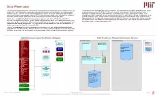
Soil Data WarehouseComponents • Design based on the Business Requirements for Soil Data Delivery and Distribution (http://nasis.nrcs.usda.gov/documents/) • Basic components includes a: • staging server: joining spatial and tabular, quality review and approval • warehouse database: maintain versions and protecting data • various data marts: provide customer access meeting data needs
Soil Data Warehouse Components (Cont.) • Other components in development and planning stage include: • Web Soil Survey: map viewing, authored text and tables • Web Soil Data Viewer: interpretative thematic map generation as part of Web Soil Survey • Online reports & interpretations, downloads, subscription services • Custom Exports and web services for unique data needs • Soils API (application programming interface): Models and applications direct connect
SDW First Phase Implementation • Primary warehouse and data mart functions to provide delivery of soil survey data • Connection to eFOTG to server Section II of official soil survey data • SSURGO product delivery • Provide reporting and downloading • Provide catalog services to Resource Data Gateway and data delivery with dynamic on-the-fly formatting and projection of spatial data
SDW Next Phase Implementation • Future phases: • Web Soil Survey (Soil Survey Publication) • Web Soil Data Viewer • Custom Export (Web services) • Soils Application Programming Interface (API)
Key Soil Data Mart Functions • Current official soil survey data and information • Version information on download page and footer in reports • Subscription service, notification when updated data for a specific soil survey • State reports capability (coming soon)
Managing Field Office Soil Data • eFOTG direct connect to Soil Data Mart for specific soil survey • Keeping field tools current (Toolkit, Soil Data Viewer, RUSLE2, etc.) • DC, Area Soil Scientist, State Agronomist subscribe to specific surveys to keep informed
Timeframe for WSS 1.0 • Alpha Release: January 2005 • Limited access (~50 users) for testing purposes • Only accessible from the USDA-SCA intranet (behind eAuth) • Beta Release: April 2005 • Further testing and interface validation • Public Release: June 2005 • To be announcement by Chief Bruce Knight • Soil Survey Division Marketing
Pathway through WSS • Define area of interest (AOI tab) • Browse soil information (SDX tab) • While browsing information, choose what to save to customized soil resource report (SDX tab) • Select/download the output report (Reports tab)
Products • Multiple Report Products • Standard Soil Survey Manuscripts (PDF) • Text, tables, and maps by SSA • Customized Soil Resource Reports (PDF) • Map units only within AOI • Content is specifically chosen by user • Thematic Maps (with tables and text) • Different format from Soil Survey Manuscript • SDM Tables as Supplemental Tables • Soil Map with labels on Ortho backdrop for an AOI
1.0 Features • Area of Interest (AOI tab) • Navigate to and define an AOI using selection criteria: • SSA, County, Watershed Boundary, Zip Code, Township/Range/Section • Assign AOI properties—AOI name, NRCS landuse, description—and save AOI • Map tools—Zoom All, Zoom AOI, Zoom Last, Zoom Forward, Identify
1.0 Features (cont.) • Soil Data Explorer tab • For soil interpretations and properties, get a summary table with ability to sort • Get terminology and concepts for all resources, land covers, and uses of land • Save specified information from the SDX to a customized soil resource report • Management tab for managing ecological sites toward a desired state
1.0 Features (cont.) • Reports • Download soil survey publication (PDF) • Get Soil Data Mart tables just for the map units in AOI • Print soil map of the AOI to 8.5 x 11 page • Get a customized soil resource report
Future Features • For Area of Interest • Define the AOI as a line or point with user defined buffer • Define an AOI using additional selection criteria, such as shape file (e.g., watershed), latitude and longitude point file, USGS 7.5-minute quadrangle • Define an AOI using land boundary geometry associated with a landowner’s NRCS customer statement
Future Features (cont.) • For Area of Interest, cont. • Create multiple, distinct AOI units within an AOI • Choose active AOI for the purpose of running suitability and limitation ratings • Select active AOIs by all, name, landuse (multi-selection) • Have a visual cue indicating the active AOI(s)
Future Features (cont.) • Set user preferences • Map viewer behavior: on or off (if performance is a concern) • Global map print options, such as page size and layout, and scale (1:24) • Global table formatting options, such as including metadata.
Future Features (cont.) • Additional Ways of Getting Reports • Order Soil Survey on CD/DVD • Order printed, bound Soil Survey • Content Management System for creating, managing, and delivering manuscripts
Future Challenges • Map finishing on the fly • System to manage authored text and keep consistent with database • Print and deliver on demand