Download
1 / 5
50 likes | 219 Views
VIIRS I-band 1 Visible (375 m) – 2 June 2014 – Paraguay Flooding. VIIRS I-band 1 Visible (375 m) – 30 June 2014 – Paraguay Flooding. Left: SNPP/VIIRS false-color image (Composited by Imager bands 3, 2, 1) on June 30, 2014 17:02 (UTC)

E N D
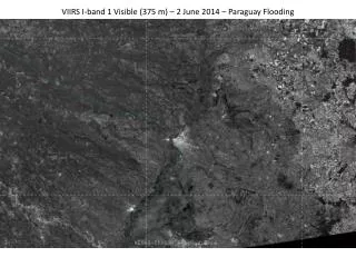
VIIRS I-band 1 Visible (375 m) – 2 June 2014 – Paraguay Flooding
VIIRS I-band 1 Visible (375 m) – 30 June 2014 – Paraguay Flooding
Left: SNPP/VIIRS false-color image (Composited by Imager bands 3, 2, 1) on June 30, 2014 17:02 (UTC) Right: SNPP/VIIRS flood detection map on June 30, 2014 17:02 (UTC) The images present an overview of the severe flood happening in South America.
Asuncion SNPP/VIIRS false-color image (composited by Imager bands 3, 2, 1) June 30, 2014 17:02 (UTC) around Asuncion, Paraguay
Asuncion SNPP/VIIRS flood detection map June 30, 2014 17:02 (UTC) around Asuncion, Paraguay